
Hobart ( HOH-bart; is the capital and most populous city of the island state of Tasmania, Australia. Located in Tasmania's south-east on the estuary of the River Derwent, it is the southernmost capital city in Australia. Despite containing nearly half of Tasmania's population, Hobart is the least-populated Australian state capital city, and second-smallest by population and area after Darwin if territories are taken into account. Its skyline is dominated by the 1,271-metre kunanyi / Mount Wellington, and its harbour forms the second-deepest natural port in the world, with much of the city's waterfront consisting of reclaimed land. The metropolitan area is often referred to as Greater Hobart, to differentiate it from the City of Hobart, one of the seven local government areas that cover the city. It has a mild maritime climate.

The Tasman Bridge is a prestressed concrete girder bridge connecting the Tasman Highway over the River Derwent in Hobart, Tasmania, Australia. When it opened on 29 March 1965, the Tasman was the longest prestressed concrete bridge in Australia, with a total length measuring 1,396 metres (4,580 ft), including approaches. The bridge provides a vital link between Hobart's city centre on the western shore and the City of Clarence on the eastern shore. Averaging 73,029 vehicle crossings per day, the bridge is the highest volume road section in Tasmania. It features five lanes of traffic including a central lane equipped for tidal flow operations and separated shared-use walkways on both sides, with ramp upgrades for improved access and cyclists completed in 2010.

Clarence City Council is a local government body in Tasmania, and one of the five municipalities that constitutes the Greater Hobart Area. The Clarence local government area has a population of 61,531, covering the eastern shore of the Derwent River from Otago to the South Arm Peninsula and the smaller localities of Cambridge, Richmond, and Seven Mile Beach.

The Tasman Highway is a highway in Tasmania, Australia. Like the Midland Highway, it connects the major cities of Hobart and Launceston – however it takes a different route, via the north-eastern and eastern coasts of the state. The Highway also acts as a major commuter road to Hobart residents living on the eastern side of the Derwent River. The designation "Tasman Highway" arises from its location facing the Tasman Sea – named, like the state itself, after Abel Tasman. The highway is one of the longest in Tasmania – 410 km (250 mi), with an average travelling time of 41⁄2 hours.

Rosny is a suburb of the City of Clarence, part of the greater Hobart area, Tasmania, Australia. It is located on the eastern shore of the Derwent River, between the suburbs of Montagu Bay and Rosny Park, approximately 4 kilometres from Hobart's centre. Rosny is the residential part of its commercial namesake Rosny Park.
Howrah is a residential locality in the local government area (LGA) of Clarence in the south-east region of Tasmania. The locality is about 5 kilometres (3.1 mi) south-east of the town of Rosny Park. The 2021 Census recorded a population of 9,545 for the suburb of Howrah. It is a suburb of the City of Clarence. It is east of Bellerive and north of Tranmere.

Lindisfarne is a suburb of Hobart's Eastern Shore, located approximately 6 kilometres from the City Centre and is part of the municipal City of Clarence.

Rosny College is a government comprehensive senior secondary school located in Rosny Park, a suburb of Hobart, Tasmania, Australia. Established in 1973, the college caters for approximately 900 students in Years 11 and 12. The college is administered by the Department for Education, Children and Young People.

Geilston Bay is a largely residential suburb of Hobart between Risdon Vale, Shag Bay, and Lindisfarne, in the City of Clarence located on the Eastern Shore of the Derwent River, taking its name from an inlet of that river of the same name. The inlet and locality were sometimes known by the alternative name "Limekiln Bay" on account of lime kilns which operated there between approximately the 1830s and the 1920s, the remains of which remained visible for some decades thereafter; another early name for the Bay was "James's Bay". The present suburb name derives from an early land holding "Geils Town" in the region purchased by Andrew Geils, Commandant of Van Diemen's Land (Tasmania) for a brief period in 1812-1813, who subsequently left his Australian holdings behind when he moved back to Scotland.
Rosny Park is a suburb of Hobart, Tasmania, located in the City of Clarence on the eastern shore of the Derwent River. It is about five kilometres from the city centre of Hobart. Rosny Park is the commercial twin of its residential namesake, Rosny.

Warrane is a suburb of Hobart, Tasmania, Australia, within the City of Clarence local government area. It is approximately 5 kilometres (3 mi) from Hobart's CBD. It is located between Rosny Park and Mornington and runs parallel to the Tasman Highway.

Rose Bay is a suburb of the City of Clarence in greater Hobart, capital city of Tasmania, Australia. Rose Bay is a small suburb, making up only approximately 0.9 square kilometres with nearly one fourth of that area (23.2%) being parkland. At the 2016 Census the suburb recorded a population of 1,102 people.
Howrah Beach is a 1.2 km (1 mi) stretch of recreational beach situated along the River Derwent in Howrah, a suburb of Hobart, Tasmania, Australia. The south-facing beach neighbours Bellerive Beach to the west and is bookended by Howrah Point to the east. The beach has views of the Derwent estuary, the neighbouring suburb of Tranmere, Sandy Bay on the western shore, and southern views of South Arm, Tinderbox and the northern tip of Bruny Island. Howrah Beach is backed by a narrow tree-lined reserve and private properties, the Clarence Foreshore Trail, Clarence High School adjoining Wentworth Park, Howrah Community Centre, Howrah Men's Shed and the Sunshine Tennis Club.
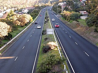
The South Arm Highway is a highway serving the southern suburbs of Hobart, on the eastern shore of the River Derwent in Tasmania, Australia. The highway is a major trunk road that carries heavy commuter traffic south from the Eastern Outlet to Howrah and Rokeby. As one of the Tasman Highway's principle Feeders and one of the eastern shore's major transport corridors, The South Arm Highway facilitates the movement of traffic between the suburbs and satellite communities to the south with the city centre and ultimately, other major cross city highways. With annual average daily traffic (AADT) of 17,000, the highway is considered a major traffic corridor within Hobart. The designation "South Arm Highway" arises from its journey south to South Arm.

Rose Bay High School is a government co-educational comprehensive secondary school located in Rose Bay, a suburb of Hobart, Tasmania, Australia. Established in 1961, the school caters for approximately 650 students from Years 7 to 12. The school is administered by the Tasmanian Department of Education.
Geilston Bay High School was a government co-educational comprehensive secondary school located in Geilston Bay, a suburb of Hobart, Tasmania, Australia. Established in 1972, the school catered for students from Years 7 to 10 until its closure in 2013.

Nutgrove Beach is a popular beach destination along the River Derwent in Sandy Bay, Hobart, Tasmania. The north facing beach has views of kunanyi / Mount Wellington, Lords Beach, Wrest Point Hotel Casino, the Tasman Bridge, and the City of Clarence on the eastern shore. Nutgrove Beach neighbours Long Beach and Red Chapel Beach, and is within close proximity to the Sandy Bay Sailing Club and Lower Sandy Bay shops. The beach is dog-friendly and has bathroom facilities.
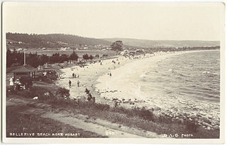
Bellerive Beach is a popular beach destination along the River Derwent in Bellerive, Hobart, Tasmania. The south facing beach neighbours the historic Kangaroo Battery coastal defences to the west and Howrah Beach to the east. The beach has views of the Derwent estuary, Howrah, Tranmere and Sandy Bay on the western shore. Bellerive Beach has an adjoining parkland with play equipment, barbecues and bathroom facilities and is backed by the Bellerive Oval, a narrow tree-lined reserve and private properties.
Taroona Beach is a popular beach destination along the River Derwent in Taroona, Hobart, Tasmania. The south facing beach looks directly out to Storm Bay and the Tasman Sea, with views of the Derwent estuary, the City of Clarence on the eastern shore, Opossum Bay, South Arm, the Alum Cliffs and northern tip of Bruny Island. Taroona Beach is situated between Hinsby Beach and Crayfish Point, home of the Fisheries and Aquaculture Centre for the Institute for Marine and Antarctic Studies. Taroona Beach contains a boat ramp and is backed by Taroona Park which contains bathroom facilities, a skate park, scout hall, the Taroona Tennis Club, and the Taroona Bowls and Community Club.

Hinsby Beach is a beach along the River Derwent in the Hobart suburb of Taroona, Australia. The south facing beach looks directly out to Storm Bay and the Tasman Sea, with views of the Derwent estuary, the Alum Cliffs, Taroona Shot Tower, the City of Clarence on the eastern shore and Opossum Bay, South Arm. Hinsby Beach is situated between the Alum Cliffs and Taroona Beach. A naturally secluded section of the beach, beyond the rocky south-western outcrop is a zoned naturist beach.


