
Forest Hill is a suburb of Melbourne, Victoria, Australia, 18 km east of Melbourne's Central Business District, located within the City of Whitehorse local government area. Forest Hill recorded a population of 10,780 at the 2021 census.
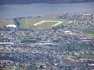
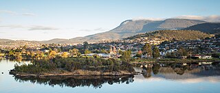
Glenorchy is a suburb of Hobart, in the state of Tasmania, Australia. Glenorchy is bound by the River Derwent to the east, Mount Wellington to the west, Hobart City to the south and Brighton to the north. The city officially begins at Creek Road New Town, in Hobart's northern suburbs, and includes, Moonah, Derwent Park, Lutana, Goodwood, Montrose, Rosetta, Berriedale, Chigwell, Claremont and Austins Ferry. It is the seat of the local government area of the same name, the City of Glenorchy.
Vermont is a suburb of Melbourne, Victoria, Australia, 21 km (13 mi) east of Melbourne's Central Business District, located within the Cities of Maroondah and Whitehorse local government areas. Vermont recorded a population of 10,993 at the 2021 census.

Hawthorn East is a suburb of Melbourne, Victoria, Australia, 7 km (4.3 mi) east of the Melbourne central business district, located within the City of Boroondara local government area. Hawthorn East recorded a population of 14,834 at the 2021 census.

Officer is a suburb of Melbourne, Victoria, Australia, 48 km south-east of Melbourne's Central Business District and the second most populous in the Shire of Cardinia after Pakenham. Officer recorded a population of 18,503 at the 2021 census.

Richmond is an inner-city suburb in Melbourne, Victoria, Australia, 3 km (1.9 mi) east of the Melbourne central business district, located within the City of Yarra local government area. Richmond recorded a population of 28,587 at the 2021 census, with a median age of 34.
Armadale is an inner suburb in Melbourne, Victoria, Australia, 7 km south-east of Melbourne's Central Business District, located within the City of Stonnington local government area. Armadale recorded a population of 9,368 at the 2021 census.

Heatherton is a suburb in Melbourne, Victoria, Australia, 19 km south-east of Melbourne's Central Business District, located within the City of Kingston local government area. Heatherton recorded a population of 2,826 at the 2021 census.

Glenorchy City Council is a local government body in Tasmania, and one of the five municipalities that constitutes the Greater Hobart Area. The Glenorchy local government area has a population of 50,411, covering the suburbs north of central Hobart on the western shore of the Derwent River, including its namesake suburb, Glenorchy.

Burnside is suburb in the City of Burnside council area in the eastern suburbs of Adelaide. It is primarily a residential suburb. Burnside is 7.5 kilometres (4.7 mi) east of the Adelaide city centre by road.

Rosebery is an inner southern suburb of Sydney, in the state of New South Wales, Australia. It is 6 kilometres south of the Sydney central business district and is part of the local government areas of the City of Sydney and the Bayside Council.
Bonner is a suburb in the district of Gungahlin in Canberra in the Australian Capital Territory, Australia.

Forest Lodge is a small, inner-city suburb of Sydney, in the state of New South Wales, Australia. Forest Lodge is located 4 kilometres south-west of the Sydney central business district and is part of the local government area of the City of Sydney.
Chigwell is a residential locality in the local government area (LGA) of Glenorchy in the Hobart LGA region of Tasmania. The locality is about 6 kilometres (3.7 mi) north-west of the town of Glenorchy. The 2016 census recorded a population of 2002 for the state suburb of Chigwell.
West Croydon is an inner western suburb of Adelaide, South Australia.
Rosetta is a residential suburb about 3 kilometres (1.9 mi) northwest of Glenorchy, located in local government area (LGA) of City of Glenorchy. In the 2021 census, Rosetta had a population of 2,833. This suburb is part of the Hobart LGA Region, nestled between Berriedale and Montrose and roughly a 15-minute drive from Hobart. Rosetta features a primary school and a high school and is bordered by the Brooker Highway along the east, adjacent to the Derwent River.

Boambee is a suburb in the city of Coffs Harbour on the Mid North Coast of New South Wales, Australia. Boambee is west of Sawtell on the Pacific Highway. It is divided into two sections: semi-rural Boambee (2450) and the more suburban Boambee East (2452). These suburbs are divided by the Pacific Highway. In 2011, Boambee had a population of 1,545 people, while Boambee East had a population of 5,446 people.

West Moonah is a residential suburb of Hobart, Tasmania, Australia. It is part of the City of Glenorchy local government area, with about 5% being in the Hobart LGA. At the 2016 Australian census, the suburb recorded a population of approximately 1,000.

Rose Bay is a suburb of the City of Clarence in greater Hobart, capital city of Tasmania, Australia. Rose Bay is a small suburb, making up only approximately 0.9 square kilometres with nearly one fourth of that area (23.2%) being parkland. At the 2016 Census the suburb recorded a population of 1,102 people.
Grantham Farm is a suburb of Sydney, in the state of New South Wales, Australia. Grantham Farm is located in north-west Sydney in the local government area of Blacktown.


