
The Sturt Highway is an Australian national highway in New South Wales, Victoria, and South Australia. The Sturt Highway is an important road link for the transport of passengers and freight between Sydney and Adelaide and the regions situated adjacent to the route.

The Midland Highway is one of Tasmania's major inter-city highways, running for 176 kilometres (109 mi) between Hobart and Launceston. It is part of the AusLink National Network and is a vital link for road freight to transport goods to and from the two cities. It represents a major north–south transportation corridor in Tasmania and has the route 1 designation as part of the National Highway. The highway consists of various traffic lane arrangements, the most common being two lanes – one in each direction, with overtaking options and at-grade intersections. At both the Launceston and Hobart sections of the highway there are small portions of grade-separated dual carriageway.

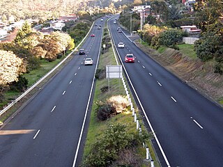
The Brooker Highway is a highway in the State of Tasmania, Australia. As one of Hobart's 3 major radials, the highway connects traffic from the Hobart city centre with the northern suburbs and is the major road connection to the cities and towns of Northern Tasmania. With an AADT of 48,000, the highway is one of the busiest in Tasmania. The Brooker Highway has recently been declared part of the National Highway.

The Tasman Highway is a highway in Tasmania, Australia. Like the Midland Highway, it connects the major cities of Hobart and Launceston – however it takes a different route, via the north-eastern and eastern coasts of the state. The Highway also acts as a major commuter road to Hobart residents living on the eastern side of the Derwent River. The designation "Tasman Highway" arises from its location facing the Tasman Sea – named, like the state itself, after Abel Tasman. The highway is one of the longest in Tasmania - 410 km (250 mi), with an average traveling time of 41⁄2 hours.

Davey Street a major one way street passing through the outskirts of the Hobart Central business district in Tasmania, Australia. Davey street is named after Thomas Davey, the first Governor of Van Diemen's Land. The street forms a one-way couplet with nearby Macquarie Street connecting traffic from the Southern Outlet in the south with traffic from the Tasman Highway to the east and the Brooker Highway to the north of the city. With annual average daily traffic of 37,200, the road is one of the busier streets in Hobart.

Great Northern Highway is an Australian highway that links Western Australia's capital city Perth with its northernmost port, Wyndham. With a length of almost 3,200 kilometres (2,000 mi), it is the longest highway in Australia, with the majority included as part of the Perth Darwin National Highway. The highway is constructed as a sealed, predominantly two-lane single carriageway, but with some single-lane bridges in the Kimberley. The Great Northern Highway travels through remote areas of the state, and is the only sealed road link between the Northern Territory and northern Western Australia. Economically, it provides vital access through the Wheatbelt and Mid West to the resource-rich regions of the Pilbara and Kimberley. In these areas, the key industries of mining, agriculture and pastoral stations, and tourism are all dependent on the highway.
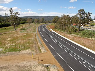
The Kingston Bypass is a A$41 million, 2.8-kilometre-long (1.7 mi) highway bypassing the southern Hobart community of Kingston, Tasmania. The proposal of a bypass was originally published in the Hobart Area Transportation Study during 1965. The bypass was completed in 2011, after the need to such a road was realised several years earlier when the Channel Highway reached an 18,000 AADT. Construction of the Bypass was made possible by an A$15 million pledge for the project, made by the Australian Labor Party during the 2007 federal election campaign. During construction total cost of the bypass blew out from the original estimate of $30 million to over $41 million.
The South Arm Highway is a highway serving the southern suburbs of Hobart, on the eastern shore of the River Derwent in Tasmania, Australia. The highway is a major trunk road that carries heavy commuter traffic south from the Eastern Outlet to Howrah and Rokeby. As one of the Tasman Highway's principle Feeders and one of the eastern shore's major transport corridors, The South Arm Highway facilitates the movement of traffic between the suburbs and satellite communities to the south with the city centre and ultimately, other major cross city highways. With annual average daily traffic (AADT) of 17,000, the highway is considered a major traffic corridor within Hobart. The designation "South Arm Highway" arises from its journey south to South Arm.
The Domain Highway is a highway in Tasmania, Australia. The highway acts as a link road connecting traffic between Hobart's two busiest highways; The Tasman Highway and the Brooker Highway while also bypassing the Hobart city centre. With recorded annual average daily traffic of 25,000, the single carriageway road is busier than some of Hobart's dual carriageway highways. Commencing at the Brooker Highway at Cornelian Bay and heading southeast between the banks of the Derwent River and the Domain and Botanical Gardens. The highway ends at the Tasman Highway, on the western approach of the Tasman Bridge.

The Brighton Bypass is a A$191 million north/south bypass of the Midland Highway diverting traffic away from the northern Hobart satellite suburbs of Brighton and Pontville. Construction of the 9.5 km federally funded dual carriageway started in April 2009, and was opened on 12 November 2012.

Algona Road is a major link road, connecting the residents of Blackmans Bay to Kingston in Southern Tasmania, Australia. The road was constructed in 1986 as a two lane road, with provision for a second carriageway when needed. A roundabout was installed on the junction with the Channel Highway in 1993 to address safety issues. The Kingston Bypass connects Algona Road to the Southern Outlet and provides a quicker route to the City of Hobart.
The Rokeby Bypass is a Tasmanian Department of State Growth proposed re-alignment of Rokeby Road that would bypass the Hobart suburb of Rokeby within the Clarence City Council. Currently there are in excess of 17,000 vehicle movements a day using Rokeby Road, a considerable amount for a two lane road. Growing community concern has been raised by the traffic issues in the Rokeby area, people South of Lauderdale are even said to be using Acton Road to gain access to the Tasman Highway.
The Kingston Interchange is a hybrid four way interchange incorporating a roundabout and elements of a trumpet interchange. It connects the Southern Outlet with the Huon Highway and the Channel Highway at Kingston, within the greater area of Hobart, Tasmania.
Nerang–Broadbeach Road is a road on the Gold Coast, Queensland, Australia. It is classified a state-controlled district road, and is part of State Route 90. The eastern section is also known as Hooker Boulevard.

The Southern Transport Investment Program is a road and rail transport plan for the northern outskirts of Hobart instituted in 2007 by the Tasmanian state government. It outlines most prominently an extensive upgrade of the Midland Highway, including the Brighton Bypass, the Bagdad Bypass and the replacement of the Bridgewater Bridge. The plan also outlines the construction of the Brighton Transport Hub and various rail alignment improvements to the Main North/South Line.

The Brighton Transport Hub is an intermodal transport hub in the northern Hobart suburb of Brighton operated by TasRail.
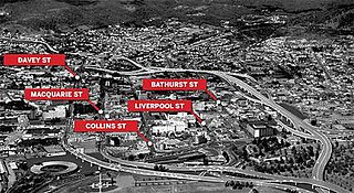
The Hobart Bypass is a proposed concept to bypass the Central Business District of Hobart, Tasmania. Currently, through traffic travels from the Tasman/Brooker Highways down the one-way Davey/Macquarie couplet to the Southern Outlet. As well as traffic concerns, there is also a call to build the bypass on the grounds that the current traffic arrangement cuts the central business district off from Hobart's waterfront.

The Hobart Area Transportation Study was a comprehensive transport plan released in 1965 for the purpose of examining the transport needs of the Australian Hobart metropolitan area over the proceeding 20 years. The study predicted the majority of the proposed traffic corridors would need to be operational by the 1985 target year.
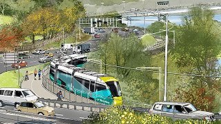
Riverline, also known as the Northern Suburbs Railway, is a proposed AU$100 million light rail system that would traverse the southernmost section of the South Railway Line, through the northern suburbs of Hobart, Tasmania.

The Toowoomba Bypass, known as Toowoomba Second Range Crossing during planning and construction, is a 41.3 km (25.7 mi) grade separated, dual carriageway bypass and partial ring road constructed to the north and west of Toowoomba, Queensland. Construction commenced in April 2016. It opened to traffic on 8 September 2019.