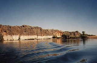
Danggu (Geikie) Gorge National Park is a national park in the Kimberley region of Western Australia, 1,837 kilometres (1,141 mi) northeast of Perth and approximately 420 km (261 mi) east of Broome by road. The gorge was originally named in honour of Sir Archibald Geikie, the Director General of Geological Survey for Great Britain and Ireland when it was given its European name in 1883. Geikie never visited the gorge and the National Park is progressively being officially changed to the Bunuba – the traditional owners of the area – name of Danggu. It is part of the Balili Conservation Park.

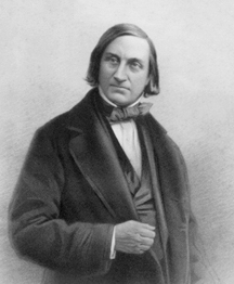
Sir Roderick Impey Murchison, 1st Baronet, was a Scottish geologist who served as director-general of the British Geological Survey from 1855 until his death in 1871. He is noted for investigating and describing the Silurian, Devonian and Permian systems.

Sir Archibald Geikie was a Scottish geologist and writer.
Edward Forbes FRS, FGS was a Manx naturalist. In 1846, he proposed that the distributions of montane plants and animals had been compressed downslope, and some oceanic islands connected to the mainland, during the recent ice age. This mechanism, which was the first natural explanation to explain the distributions of the same species on now-isolated islands and mountain tops, was discovered independently by Charles Darwin, who credited Forbes with the idea. He also incorrectly deduced the so-called azoic hypothesis, that life under the sea would decline to the point that no life forms could exist below a certain depth.

The West Coast Range is a mountain range located in the West Coast region of Tasmania, Australia.
Lake Margaret is a concrete-faced gravity dam with an uncontrolled spillway across the Yolande River, located on the north side of Mount Sedgwick, in the West Coast Range, West Coast of Tasmania, Australia.

James Murdoch Geikie PRSE FRS LLD was a Scottish geologist. He was professor of geology at Edinburgh University from 1882 to 1914.
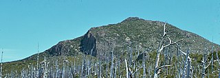
Mount Sedgwick is a mountain located within the West Coast Range, in the West Coast region of Tasmania, Australia.
Mount Geikie is a mountain in the West Coast Range of Western Tasmania, Australia.
Geikie is a surname. Notable people with the surname include:
Geikie Glacier flows northeast to Mercer Bay, at the southwest end of Cumberland West Bay, South Georgia. It was first charted by the Swedish Antarctic Expedition, 1901–04, under Otto Nordenskiöld, who named it after Sir Archibald Geikie, a noted Scottish geologist and Director-General of the Geological Survey of Great Britain, 1882–1901.

Knockan Crag lies within the North West Highlands Geopark in the Assynt region of Scotland 21 kilometres (13 mi) north of Ullapool. During the nineteenth century Knockan Crag became the subject of much debate when geologists noted that the Moine schists at the top of the crag appeared to be older than the Cambrian and Ordovician rocks such as Durness limestone lower down. Disagreements over the processes that could have caused this to occur were referred to at the time as the "Highlands Controversy". The argument was primarily between Roderick Murchison and Archibald Geikie on the one hand and James Nicol and Charles Lapworth on the other. Murchison and Geikie believed the sequence was wrong and that the Moine schists must be the younger rocks. The controversy was finally resolved by the work of Ben Peach and John Horne whose 1907 paper on the subject remains a classic text. Peach and Horne demonstrated that the situation resulted from the action of a thrust fault - this being the first to be discovered anywhere in the world. The older rocks had been moved some 70 kilometres to the west over the top of the younger rocks due to tectonic action.
Geikie Nunatak is a nunatak 3 nautical miles (6 km) west of Mount Absalom in the southwestern end of the Herbert Mountains of the Shackleton Range, Antarctica. It was photographed from the air by the U.S. Navy in 1967, and surveyed by the British Antarctic Survey, 1968–71. In association with the names of glacial geologists grouped in this area, it was named by the UK Antarctic Place-Names Committee in 1971 after James Geikie, Professor of Geology at the University of Edinburgh from 1882, who was one of the first to recognize that multiple glaciations occurred during the Pleistocene period.

The Ramparts are a mountain range in the Canadian Rockies. Part of the Park Ranges, they straddle the Continental Divide and lie partly within Jasper National Park in Alberta and Mount Robson Provincial Park in British Columbia.
Geikie is a locality in Alberta, Canada.

Mount Geikie, pronounced like "geeky", is a 3,298-metre (10,820-foot) mountain summit located in Mount Robson Provincial Park in British Columbia, Canada. Situated 28 km (17 mi) southwest of Jasper near the Tonquin Valley, Mount Geikie is the highest peak of The Ramparts in the Canadian Rockies, one of the most beautiful mountain meccas in the world. Its nearest higher peak is Mount Fraser, 8.0 km (5.0 mi) to the southeast, and the Continental Divide lies 3.0 km (1.9 mi) to the east. Mount Geikie is composed of quartzite of the Cambrian period. This rock was pushed east and over the top of younger rock during the Laramide orogeny. The vertical wall of its north face is over 1,500-metre (4,900-foot) high, and has been compared to the other great north faces of the Canadian Rockies such as North Twin, Alberta, and Kitchener.
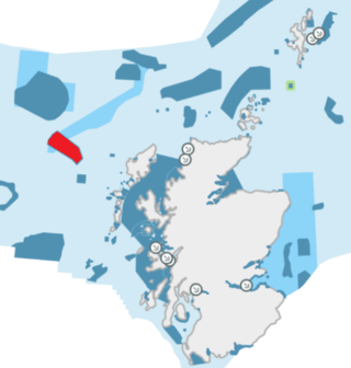
The Geikie Slide is a submarine landslide on the seabed of the North Atlantic Ocean to the northwest of Scotland. The slide occurs in a region known as the Hebridean Slope, the continental slope where the seabed drops from the continental shelf surrounding Britain into the deep ocean. Since 2014 an area of 2,215 square kilometres (855 sq mi) has been designated as a Nature Conservation Marine Protected Area under the name Geikie Slide and Hebridean Slope MPA.

Mount Geikie is a 12,378-foot-elevation (3,773-meter) mountain summit in Sublette County, Wyoming, United States.