
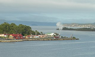
Strahan, is a small town and former port on the west coast of Tasmania. It is now a significant locality for tourism in the region.

Macquarie Harbour is a shallow fjord in the West Coast region of Tasmania, Australia. It is approximately 315 square kilometres (122 sq mi), and has an average depth of 15 metres (49 ft), with deeper places up to 50 metres (160 ft). It is navigable by shallow-draft vessels. The main channel is kept clear by the presence of a rock wall on the outside of the channel's curve. This man-made wall prevents erosion and keeps the channel deep and narrow, rather than allowing the channel to become wide and shallow. A reported Aboriginal name for the harbour is Parralaongatek.
Regatta Point is the location of a port and rail terminus on Macquarie Harbour.

Hells Gates is the name of the mouth of Macquarie Harbour on the West Coast of Tasmania, Australia.
Mount Sorell is a mountain located in the West Coast region of Tasmania, Australia.

Cape Sorell is a headland located in the Southern Ocean outside Macquarie Harbour on the West Coast of Tasmania, Australia. The cape and the Cape Sorell Lighthouse, located above the headland, are important orientation points for all vessels entering the Macquarie Heads and then through Hells Gates at the entrance to the harbour.
The history of the Railways on the West Coast of Tasmania has fascinated enthusiasts from around the world, because of the combination of the harsh terrain in which the railways were created, and the unique nature of most of the lines.
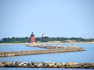
The Delaware Breakwater East End Light is a lighthouse located on the inner Delaware Breakwater in the Delaware Bay, just off the coast of Cape Henlopen and the town of Lewes, Delaware.
Mount Strahan is a mountain located on the West Coast Range in the West Coast region of Tasmania, Australia. With an elevation of 855 metres (2,805 ft) above sea level, the mountain is situated directly east of Macquarie Harbour and, like Mount Sorell, dominates the east side of the harbour near Sarah Island.
Bathurst Harbour is a shallow bay located in the south west region of Tasmania, Australia. Bathurst Harbour is contained within the Port Davey/Bathurst Harbour Marine Nature Reserve, and the Southwest National Park, part of the Tasmanian Wilderness World Heritage Area.

Victoria Harbour is a harbour, seaport, and seaplane airport in the Canadian city of Victoria, British Columbia. It serves as a cruise ship and ferry destination for tourists and visitors to the city and Vancouver Island. It is both a port of entry and an airport of entry for general aviation. Historically it was a shipbuilding and commercial fishing centre. While the Inner Harbour is fully within the City of Victoria, separating the city's downtown on its east side from the Victoria West neighbourhood, the Upper Harbour serves as the boundary between the City of Victoria and the district municipality of Esquimalt. The inner reaches are also bordered by the district of Saanich and the town of View Royal. Victoria is a federal "public harbour" as defined by Transport Canada. Several port facilities in the harbour are overseen and developed by the Greater Victoria Harbour Authority, however the harbour master's position is with Transport Canada.
The Low Rocky Point is a location on the south west coast of Tasmania and Australia, that is used as a location for weather forecasting. It is almost due west of Hobart, it is south of Point Hibbs and north of South West Cape.

Bonnet Island is a low island with an area of 2.21 ha. It lies at the entrance to Macquarie Harbour in Western Tasmania Australia, in the vicinity of Hells Gates. Due to its location and proximity to the entrance, it was involved as part the Macquarie Harbour Breakwater construction.

Fremantle Harbour is Western Australia's largest and busiest general cargo port and an important historical site. The inner harbour handles a large volume of sea containers, vehicle imports and livestock exports, cruise shipping and naval visits, and operates 24 hours a day. It is located adjacent to the city of Fremantle, in the Perth metropolitan region.
Point Hibbs is a headland on the south-west coast of Tasmania, Australia. The headland is located south of the most southern point of Macquarie Harbour, and west of the Gordon River. It is the next named feature along the coast south of Cape Sorell that is used to delineate sections of the coast. Like South West Cape, it is used as a reference point for nearby wrecks.

The South Mole is a breakwater located in the southern section of Gibraltar Harbour, in the British Overseas Territory of Gibraltar, at the southern end of the Iberian Peninsula. Previously known as the New Mole and New Mole Extension, the South Mole, with the rest of harbour, is just north of the east entrance to the Strait of Gibraltar.

The North Mole is a breakwater located in the northern section of Gibraltar Harbour, in the British Overseas Territory of Gibraltar, at the southern end of the Iberian Peninsula. The North Mole, with the rest of harbour, is just north of the east entrance to the Strait of Gibraltar. The breakwater was formerly known as the Commercial Mole, and is the site of the commercial port in the harbour. It was the consequence of a late nineteenth century plan by the British Admiralty to create a modern dockyard and large defensive harbour in Gibraltar.
The Cape Sorell Lighthouse is a heritage-listed lighthouse that is located on Cape Sorell in the West Coast region of Tasmania, Australia. The lighthouse is situated approximately 12 kilometres (7.5 mi) southwest of Strahan.