The House of Assembly, or Lower House, is one of the two chambers of the Parliament of Tasmania in Australia. The other is the Legislative Council or Upper House. It sits in Parliament House in the state capital, Hobart.

The Franklin Dam or Gordon-below-Franklin Dam project was a proposed dam on the Gordon River in Tasmania, Australia, that was never constructed. The movement that eventually led to the project's cancellation became one of the most significant environmental campaigns in Australian history.

Clarence City Council is a local government body in Tasmania, and one of the five municipalities that constitutes the Greater Hobart Area. The Clarence local government area has a population of 61,531, covering the eastern shore of the Derwent River from Otago to the South Arm Peninsula and the smaller localities of Cambridge, Richmond, and Seven Mile Beach.
The Parliament of Tasmania is the bicameral legislature of the Australian state of Tasmania. It follows a Westminster-derived parliamentary system and consists of the Governor of Tasmania, the Tasmanian House of Assembly, and Tasmanian Legislative Council. Since 1841, both Houses have met in Parliament House, Hobart. The Parliament of Tasmania first met in 1856.

The Division of Braddon is an Australian electoral division in the state of Tasmania. The current MP is Gavin Pearce of the Liberal Party, who was elected at the 2019 federal election.

The Division of Franklin is an Australian electoral division in Tasmania.

The Supreme Court of Tasmania is the highest State court in the Australian State of Tasmania. In the Australian court hierarchy, the Supreme Court of Tasmania is in the middle level, with both an appellate jurisdiction over lower courts, and decisions made by Court to be heard on appeal by the High Court of Australia.

The electoral division of Franklin is one of the five electorates in the Tasmanian House of Assembly, located in southern Tasmania and includes Bruny Island, Kingston and the eastern shore of the Derwent River. Franklin is named after Sir John Franklin, the Arctic explorer who was Lieutenant-Governor of Van Diemen's Land (1837–43). The division shares its name and boundaries with the federal division of Franklin.

The electoral division of Pembroke is one of the 15 electorates or 'seats' in the Tasmanian Legislative Council or upper house. It is located on Hobart's Eastern Shore and includes a number of suburbs; Risdon Vale, Geilston Bay, Rose Bay, Lindisfarne, Warrane, Mornington, Bellerive, Howrah and Tranmere. In earlier times, the division included most of the east coast of Tasmania as far north as Bicheno, including the Tasman Peninsula.
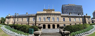
Parliament House, Hobart, located on Salamanca Place in Hobart, Tasmania, Australia, is the meeting place of the Parliament of Tasmania. The building was originally designed as a customs house but changed use in 1841 when Tasmania achieved self-government. The building served both purposes from 1841 to 1904, when the customs offices were relocated.
Lenah Valley is a suburb of Hobart, Tasmania. It is situated in the foothills of Mount Wellington, north of the CBD between Mount Stuart, New Town and the City of Glenorchy.

Lands administrative divisions of Australia are the cadastral divisions of Australia for the purposes of identification of land to ensure security of land ownership. Most states term these divisions as counties, parishes, hundreds, and other terms. The eastern states of Queensland, New South Wales, Victoria, and Tasmania were divided into counties and parishes in the 19th century, although the Tasmanian counties were renamed land districts in the 20th century. Parts of South Australia (south-east) and Western Australia (south-west) were similarly divided into counties, and there were also five counties in a small part of the Northern Territory. However South Australia has subdivisions of hundreds instead of parishes, along with the Northern Territory, which was part of South Australia when the hundreds were proclaimed. There were also formerly hundreds in Tasmania. There have been at least 600 counties, 544 hundreds and at least 15,692 parishes in Australia, but there are none of these units for most of the sparsely inhabited central and western parts of the country.

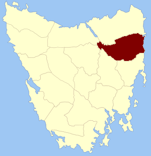
Devon Land District is one of the twenty land districts of Tasmania which are part of the Cadastral divisions of Tasmania. It was formerly one of the 18 counties of Tasmania. The 1911 Encyclopædia Britannica describes Beaconsfield and Devonport as being in the county. It is bordered by the Tamar River in the east, and the Emu River near Burnie in the west. Deloraine is on the southern edge with the border with Westmoreland Land District. It is named after the English county of Devon.
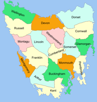
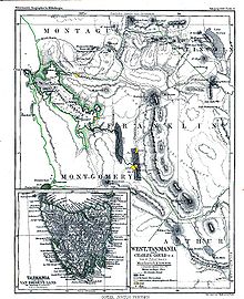
The Lands administrative divisions of Tasmania are the divisions of Tasmania into land districts and parishes for cadastral purposes, which are part of the lands administrative divisions of Australia. There are 20 land districts in Tasmania, although in the early nineteenth century there were several other systems, with 18 or 36 counties and 9 other divisions used, as well as hundreds. The land districts include the 18 former counties of the island of Tasmania which were renamed but retain the same boundaries, plus King Island and Flinders Island. The counties are referenced in the 1911 Encyclopædia Britannica, with Hobart described as being in Buckingham County, Launceston in Cornwall County and Beaconsfield in Devon County. The land districts are used for land titles today, while the Local Government Areas of Tasmania with cities and municipalities are used for political and administrative purposes.
41.55°S 147.75°E

Kent Land District is one of the twenty land districts of Tasmania which are part of the Cadastral divisions of Tasmania. It was formerly one of the 18 counties of Tasmania. It is located on the southern tip of Tasmania. It is bordered by the Huon River to the north, and Picton River to the north-west. It includes Dover, Geeveston and Southport, and part of the Southwest National Park.
The 18 former counties of Tasmania, renamed as Land Districts:
In the Australian state of Tasmania, there are many areas which are commonly known by regional names. Regions are areas that share similar characteristics. These characteristics may be natural such as the Furneaux Islands, the coastline, or the Central Highlands. Alternatively, the characteristics may be cultural, such as a viticulture land use. Tasmania is divided by numerous regional boundaries, based on different characteristics. In many cases boundaries defined by different government agencies are coterminous and are often cited by the Australian and local media that tend to distinguish between North West, West Coast, Southern, and East Coast.
Kutikina Cave is a rock shelter located on the Franklin River in the South West Wilderness, a World Heritage Area in the Australian state of Tasmania.