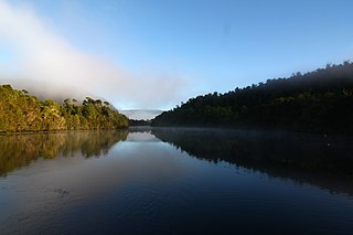
The Pieman River is a major perennial river located in the west coast region of Tasmania, Australia.

The West Coast Range is a mountain range located in the West Coast region of Tasmania, Australia.
Lake Margaret is a concrete-faced gravity dam with an uncontrolled spillway across the Yolande River, located on the north side of Mount Sedgwick, in the West Coast Range, West Coast of Tasmania, Australia.

The West Coast of Tasmania is mainly isolated rough country, associated with wilderness, mining and tourism. It served as the location of an early convict settlement in the early history of Van Diemen's Land, and contrasts sharply with the more developed and populous northern and eastern parts of the island state.
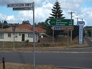
The Murchison Highway is a highway located in the West Coast region of Tasmania, Australia. The 147-kilometre (91 mi) highway runs generally north–south, with Somerset, near Burnie, as its northern terminus and Zeehan as its southern terminus. The highway was opened on 13 December 1963. Part of the highway from Waratah to Burnie was known as the Waratah Highway until 1973.
The Crotty Dam, also known during construction as the King Dam, or the King River Dam on initial approval, is a rockfill embankment dam with a controlled and uncontrolled spillway across the King River, between Mount Jukes and Mount Huxley, located in Western Tasmania, Australia.
The Bastyan Power Station is a conventional hydroelectric power station located in Western Tasmania, Australia.
The Mackintosh Power Station is a conventional hydroelectric power station located in Western Tasmania, Australia.
The Reece Power Station is a conventional hydroelectric power station located in the West Coast region of Tasmania, Australia.
The Tribute Power Station is a conventional hydroelectric power station located in Western Tasmania, Australia.

The Wee Georgie Wood Railway is a 2 ft narrow gauge tourist tramway running from Tullah, on a 1.9 km (1.2 mi) short track by the edge of Lake Rosebery in the West Coast Municipality of Tasmania.
Tullah is a town in the northern part of the West Coast Range, on the west coast of Tasmania, about 111 km south of Burnie. The town has a population of approximately 202 people.
The Murchison River, part of the Pieman River catchment, is a major perennial river located in the West Coast region of Tasmania, Australia.
The Mackintosh River, part of the Pieman River catchment, is a major perennial river located in the West Coast region of Tasmania, Australia. The river was named in November 1828 by Henry Hellyer, a surveyor of the Van Diemans Land Company, in honour of Sir James Mackintosh, son of John Mackintosh of Kyllachy, Inverness-shire
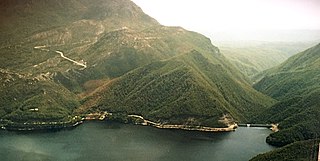
Lake Mackintosh is a 17.5-kilometre-long (10.9 mi) reservoir with a surface area of 3,100-hectare (7,700-acre) that forms part of the Pieman power development running north–south past Mount Farrell, adjacent to the town of Tullah in Tasmania.
Lake Pieman is a man-made reservoir created by the damming of the Pieman River, located in the West Coast region of Tasmania, Australia.
The Anthony Power Development Scheme, part of the Pieman River power development scheme, was a proposed scheme for damming parts of the upper catchment of the Pieman River in Western Tasmania, Australia.
The Anthony River, part of the Pieman River catchment, is a perennial river in the West Coast region of Tasmania, Australia.
Lake Murchison is a man-made water reservoir located in the western region of Tasmania, Australia. The lake is situated within the northern part of Tasmania's West Coast Range and is fed by the Murchison River, the George Creek, the Anthony River, and discharge from the Tribute Power Station.
Pieman River Power Development was a major 1970s and 1980s hydroelectric development of the Pieman River and its tributaries on the west coast of Tasmania.

