The Great Lake, officially yingina / Great Lake, is a natural lake and man-made reservoir that is located in the central northern region of Tasmania, Australia.

The Lyell Highway is a highway in Tasmania, running from Hobart to Queenstown. It is the one of two transport routes that passes through the West Coast Range, the other being the B28 Anthony Road.

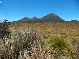
The West Coast Range is a mountain range located in the West Coast region of Tasmania, Australia.
Lake Margaret is a concrete-faced gravity dam with an uncontrolled spillway across the Yolande River, located on the north side of Mount Sedgwick, in the West Coast Range, West Coast of Tasmania, Australia.
Crotty is the site of a former gazetted town in Western Tasmania, Australia. The town was on the southern bank of the King River, on the eastern lower slopes of Mount Jukes, below the West Coast Range. The locality was formerly named King River

Lake Burbury is a man-made water reservoir created by the Crotty Dam inundating the upper King River valley that lies east of the West Coast Range. Discharge from the reservoir feeds the John Butters Hydroelectric Power Station, owned and operated by Hydro Tasmania.
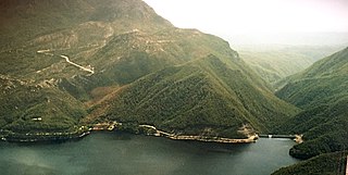
The Crotty Dam, also known during construction as the King Dam, or the King River Dam on initial approval, is a rockfill embankment dam with a controlled and uncontrolled spillway across the King River, between Mount Jukes and Mount Huxley, located in Western Tasmania, Australia.
Miena is a small town at the southern end of the Great Lake in the Central Highlands of Tasmania, Australia. At the 2021 census, Miena and the surrounding area had a population of 127.

The Central Highlands is a region in Tasmania, Australia where geographical and administrative boundaries closely coincide. It is also known as The Lake Country of Tasmania.

The Tarraleah Power Station is a hydroelectric power station located in the Central Highlands region of Tasmania, Australia. The power station is part of the Upper Derwent hydro scheme and is operated by Hydro Tasmania.

The Tungatinah Power Station is a conventional hydroelectric power station located in the Central Highlands region of Tasmania, Australia. The power station is situated on the Upper River Derwent catchment and is owned and operated by Hydro Tasmania.
The Lake Echo Power Station is a conventional hydroelectric power station located in the Central Highlands region of Tasmania, Australia. The power station is situated on the Upper River Derwent catchment and is owned and operated by Hydro Tasmania.
Tarraleah is a rural locality in the local government area (LGA) of Central Highlands in the Central LGA region of Tasmania. The locality is about 53 kilometres (33 mi) north-west of the town of Hamilton. The 2016 census has a population of nil for the state suburb of Tarraleah.
Bronte Park is a rural locality in the local government area (LGA) of Central Highlands in the Central LGA region of Tasmania. The locality is about 82 kilometres (51 mi) north-west of the town of Hamilton. The 2016 census recorded a population of 28 for the state suburb of Bronte Park. It is a locality on the Marlborough Highway at the southern edge of the Cradle Mountain-Lake St Clair National Park. It is located just north of the Lyell Highway and approximately halfway in between Hobart and Queenstown, and is also almost exactly in the geographic centre of the island.

The Gordon Dam, also known as the Gordon River Dam, is a major gated double curvature concrete arch dam with a controlled spillway across the Gordon River, located in Southwest National Park, Tasmania, Australia. The impounded reservoir is called Lake Gordon.
The Scotts Peak Dam is a rockfill embankment dam without a spillway across the Huon River, located in the South West region of Tasmania, Australia.
The Serpentine Dam is a rockfill embankment dam with a concrete face and a controlled spillway across the Serpentine River, located in the South West region of Tasmania, Australia.
The Anthony Power Development Scheme, part of the Pieman River power development scheme, was a proposed scheme for damming parts of the upper catchment of the Pieman River in Western Tasmania, Australia.
The King William Range is a mountain range in the South West Wilderness, Tasmania, Australia. It is situated south of the Lyell Highway and Derwent Bridge. It is the source of the Gordon River catchment.
Bradys Lake is a rural locality in the local government area (LGA) of Central Highlands in the Central LGA region of Tasmania. The locality is about 68 kilometres (42 mi) north-west of the town of Hamilton. The 2016 census recorded a population of 53 for the state suburb of Bradys Lake.
