
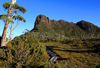
Cradle Mountain is a locality and mountain in the Central Highlands region of the Australian state of Tasmania. The mountain is situated in the Cradle Mountain-Lake St Clair National Park.

Lake St Clair or leeawulenna is a natural freshwater lake located in the Central Highlands area of Tasmania, Australia. The lake forms the southern end of the Cradle Mountain-Lake St Clair National Park. It has an area of approximately 45 square kilometres (17 sq mi), and a maximum depth of 215 metres (705 ft), making it Australia's deepest lake.

Mount Ossa is the highest mountain in Tasmania, with a summit elevation of 1,617 metres (5,305 ft) above sea level. It makes up part of the Pelion Range within Cradle Mountain-Lake St Clair National Park in the Central Highlands region of Tasmania, Australia.

The Overland Track is an Australian bushwalking track, traversing Cradle Mountain-Lake St Clair National Park, within the Tasmanian Wilderness World Heritage Area. It is walked by more than nine thousand people each year, with numbers limited in the warmer months. Officially the track runs for 65 kilometres (40 mi) from Cradle Mountain to Lake St Clair however many choose to extend it by walking along Lake St Clair for an extra day, bringing it to 82 kilometres (51 mi). It winds through terrain ranging from glacial mountains, temperate rainforest, wild rivers and alpine plains.

Mount Owen is a mountain directly east of the town of Queenstown on the West Coast Range in Western Tasmania, Australia.

Mount Huxley is a mountain located on the West Coast Range in the West Coast region of Tasmania, Australia. With an elevation of 926 metres (3,038 ft) above sea level, the mountain was named by Charles Gould in 1863 in honour of Professor Thomas Henry Huxley.

Mount Murchison is a mountain on the West Coast Range, located in the West Coast region of Tasmania, Australia.

The Eldon Range is a mountain range located in the west coast region of Tasmania, Australia.

Barn Bluff is a mountain located in the Central Highlands region of Tasmania, Australia. The mountain is situated in the Cradle Mountain-Lake St Clair National Park at the junction of the easternmost points of the Murchison and Mackintosh river catchments.

Mount Pelion West is a mountain located in the Central Highlands region of Tasmania, Australia. The mountain is part of the Pelion Range and is situated within the Cradle Mountain-Lake St Clair National Park at the easternmost boundary of the Murchison River catchment.

Mount Pelion East is a mountain located in the Central Highlands region of Tasmania, Australia. The mountain is situated within the Cradle Mountain-Lake St Clair National Park.

The Du Cane Range is a mountain range in the Central Highlands region of Tasmania, Australia.
Mount Massif is a mountain in the Central Highlands region of Tasmania, Australia. Situated in the Cradle Mountain-Lake St Clair National Park, the mountain is part of the Du Cane Range.

Mount Geryon is a mountain in the Central Highlands region of the Australian state of Tasmania. The mountain is part of the Du Cane Range and is situated within the Cradle Mountain-Lake St Clair National Park.
Mount Thetis is a mountain in the Central Highlands region of Tasmania, Australia. It is part of the Pelion Range and is situated within the Cradle Mountain-Lake St Clair National Park. It is a major feature of the national park, and is a popular venue with bushwalkers and mountain climbers.
The Acropolis is a mountain in the Central Highlands region of Tasmania, Australia. Situated in the Cradle Mountain-Lake St Clair National Park, the mountain is part of the Du Cane Range.
The Smithies Peak, sometimes incorrectly called Smithies Towers, is a mountain in the Central Highlands region of Tasmania, Australia. The mountain is situated in the Cradle Mountain-Lake St Clair National Park.
The Pelion Range is a mountain range in the Cradle Mountain-Lake St Clair National Park, Tasmania, Australia.

The Tyndall Range, commonly called The Tyndalls, is a mountain range that is part of the West Coast Range located in the Western region of Tasmania, Australia.
Mount Olympus is a mountain in the Cradle Mountain-Lake St Clair National Park in Tasmania, Australia. It is the 24th highest mountain in Tasmania at 1,472 metres (4,829 ft) above sea level and is situated about 8 kilometres (5.0 mi) South-East of Mount Gould and about 4 kilometres (2.5 mi) west of Lake St. Clair.

