Stacks Bluff

Last updated

Stacks Bluff
Stacks Bluff.jpg
Stacks Bluff from summit cairn
Highest point
Elevation 1,527 m (5,010 ft) [1] [2]
Prominence 208 m (682 ft) [2]
Parent peak Legges Tor
Isolation 8.8 km (5.5 mi) [2]
Listing 9th highest mountain in Tasmania [2]
Coordinates 41°37′12″S147°40′48″E / 41.62000°S 147.68000°E / -41.62000; 147.68000 (Stacks Bluff) Coordinates: 41°37′12″S147°40′48″E / 41.62000°S 147.68000°E / -41.62000; 147.68000 (Stacks Bluff) [3]
Geography
Relief Map of Tasmania.png
Red triangle with thick white border.svg
Stacks Bluff
Location in Tasmania
LocationNortheast Tasmania, Australia
Parent range Ben Lomond
Geology
Age of rock Jurassic
Mountain type Dolerite
Climbing
First ascent
Plangermaireener (circa?); Aboriginal

John Batman (1820s); European

The Stacks Bluff is a peak in northeast Tasmania, Australia. The mountain is situated on the Ben Lomond plateau.

Contents

At 1,527 metres (5,010 ft) above sea level, it is the ninth highest mountain in Tasmania, [2] and is a feature visible throughout the Tasmanian Midlands - prominent due to its extensive promontory cliff-line and exposed dolerite columns.

Aboriginal history of Stacks Bluff

The mountain was originally occupied by Aboriginal Tasmanians of the Ben Lomond nation, who inhabited the plateau in summer and left evidence of campsites and artefacts at Lake Youl (Palawa: meenemata) 2-kilometre (1.2 mi) north of the summit block of Stacks Bluff. [4] [5] The clans of the Ben Lomond nation who occupied this area were the Plangermaireener and Plindermairhemener, who regularly traversed the river valleys and marshes below Stacks Bluff.

The Aboriginal names for Stacks Bluff and surrounds are uncertain but modern etymological research has determined this toponymy:

Both the ethnographic record and archaeological evidence describes their habitation and visitation of the country surrounding the peak and, in particular John Batman, in 1829, describes the "native track" up onto the plateau from the foothills and he remarked at the extensive evidence of summer occupation - with remains of firing seen about the plateau. [9] [4] [7] Batman, whilst prosecuting his commission to round up the Ben Lomond clans in a "roving party", [10] also wrote in his diary in 1830:

Made round to the stacks of the mountain (i.e. Stacks Bluff), and stopped on a spot where the women said would be the most likely the Blacks would come or pass, that it was the usual beat for them. [11]

Modern European history

John Batman was likely to have been the first European to have visited the area, as he records crossing the plateau to his farm on the Ben Lomond Rivulet in the 1820s. The artist John Glover ascended the plateau in January 1833 and sketched the northern aspect of Stacks Bluff, as well as the prominent features around the peak. [12]

The name Ben Lomond originally pertained only to the southern part of the Ben Lomond plateau and the southern extremity of Stacks Bluff was originally named "the Butts" (cf. butte) by European colonials and then, colloquially, as "the Stacks" - on account of the rock columns (wikt:stack) on the southern aspect of the bluff. [13] The toponym "Stacks Bluff" first appears on maps in 1915. [14]

The "uppermost peak" of the Bluff (the first prominent isolated eminence) was hitherto known locally as Ernest Crag (or Craig), although this name no longer appears on modern maps. [15]

In 1841 the plateau was surveyed by the Polish explorer Strzelecki who incorrectly calculated barometrically the summit of the plateau as being Stacks Bluff at 5,002 feet (1,525 m). [14] After a further survey by James Sprent, the peak had a trigonometric survey point and an elaborate summit cairn constructed by convict workers in 1852. The trig station was "89 feet high" and constructed from timber carried up by manual labour from the valley below. [16] The trigonometric station was called "the Stockade" by locals, on account of the palisade surrounding the central cairn, but by the turn of the 20th century it had largely disappeared. [17]

A full survey of Ben Lomond was conducted from September 1905 to 1912 by Colonel William Vincent Legge, Stacks Bluff was found to be the second highest feature on the plateau at this time. [17]

Mining around the Bluff

Mining became established in the foothills of Stacks Bluff from the late 1800s to the 1950s. Tin and tungsten were the principal minerals to be obtained here and the townships of Rossarden and Storys Creek arose to support this commercial activity. Coal was found at Buffalo Brook, about half way between Stacks Bluff and Avoca, whereupon the Stanhope Mine was established.

Hiking

Recreational walking on and around the plateau was established from at least the mid 1830s, usually with the purpose of summiting Stacks Bluff [18] but it was not until the 1880s, when the mines had brought large numbers into the area, that walking on the plateau became popular. At this time the principal track to the plateau lay across the Ben Lomond Marshes ascending the western side of Stacks Bluff. This track led from Avoca, up Castle Cary Rivulet to the Ben Lomond Marshes, and thence to the plateau on the western side of Stacks Bluff along the headwaters of the Ben Lomond Rivulet. The track was described as passing up the "Ploughed Fields" (the scree slope below Stacks Bluff) and then proceeding through a pass between Wilmot Bluff and the western cliff line called by locals "the Gap". [19] Avoca, being located on the Fingal train line from Launceston, was the staging point for excursions to the mountain, with local guides arranging packhorses, camping equipment and suitable campsites below the plateau. [20] [21]

Excursions in the 1880s became popular enough for a landowner to build a two-storey hotel with 12 rooms, a store, bakehouse and stables at the northern end of the Ben Lomond Marshes for the use of excursionists and miners. [22] [23] This was the Ben Lomond Hotel, which was built in 1883, and was a popular staging point for the walk up to the plateau, but by 1908 the hotel had been abandoned and fallen into disrepair. [14] [24] [25] The Ben Lomond Hotel continued to be used as a staging hut for guided excursions up to the plateau from Avoca into the 20th century. [26] [21]

Stacks Bluff is a major feature of the national park, and is still a popular walking destination for both bushwalkers and mountain climbers. [27] The most popular walking track now leads from Storys Creek to the summit and the peak may also be accessed from the ski-fields across the trackless, although open, plateau. [28] [29]

See also

Related Research Articles

<span class="mw-page-title-main">Aboriginal Tasmanians</span> Indigenous people of the Australian island state of Tasmania

The Aboriginal Tasmanians are the Aboriginal people of the Australian island of Tasmania, located south of the mainland. For much of the 20th century, the Tasmanian Aboriginal people were widely, and erroneously, thought of as being an extinct cultural and ethnic group that had been intentionally exterminated by white settlers. Contemporary figures (2016) for the number of people of Tasmanian Aboriginal descent vary according to the criteria used to determine this identity, ranging from 6,000 to over 23,000.

<span class="mw-page-title-main">George Town, Tasmania</span> Town in Tasmania, Australia

George Town is a large town in north-east Tasmania, on the eastern bank of the mouth of the Tamar River. The Australian Bureau of Statistics records the George Town Municipal Area had a population of 6,764 as of 30 June 2016.

<span class="mw-page-title-main">Frenchmans Cap</span> Mountain in Western Tasmania, Australia

Frenchmans Cap is a mountain in the West Coast region of Tasmania, Australia. The mountain is situated in the Franklin-Gordon Wild Rivers National Park.

<span class="mw-page-title-main">Ben Lomond (Tasmania)</span> Mountain in the north of Tasmania

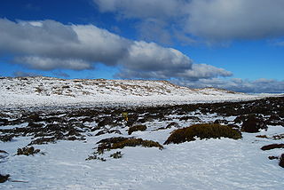
Ben Lomond is a mountain in the north-east of Tasmania, Australia.

<span class="mw-page-title-main">Deddington, Tasmania</span> Town in Tasmania, Australia

Deddington is a rural locality in the local government area (LGA) of Northern Midlands in the Central LGA region of Tasmania. The locality is about 34 kilometres (21 mi) east of the town of Longford. The 2016 census has a population of 121 for the state suburb of Deddington. The town is situated on the Nile River and lies in the foothills of Ben Lomond.

<span class="mw-page-title-main">South Esk River</span> River in Tasmania, Australia

The South Esk River, the longest river in Tasmania, is a major perennial river located in the northern region of Tasmania, Australia.

<span class="mw-page-title-main">North Esk River</span> River in northern Tasmania, Australia

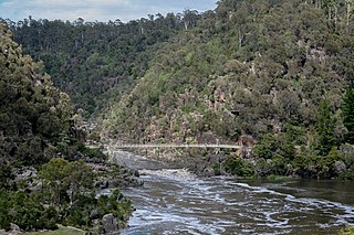
The North Esk River is a major perennial river located in the northern region of Tasmania, Australia.

<span class="mw-page-title-main">Evandale, Tasmania</span> Town in Tasmania, Australia

Evandale is an historic town in northern Tasmania, Australia. It sits on the banks of the South Esk River, 18 km south of Launceston. Named after early colonial explorer and Surveyor-General George Evans, the town is famous for its late-Georgian and early-Victorian buildings with relatively untouched streetscape, a popular Sunday market and as a host to the annual World Penny Farthing bicycle Championships. At the 2016 census, Evandale had a population of 1,345.

The Eldon Range is a mountain range located in the west coast region of Tasmania, Australia.

<span class="mw-page-title-main">Legges Tor</span>

The Legges Tor is the summit of the Ben Lomond mountain range in northeast Tasmania, Australia.

Sport in Tasmania is participation in and attendance at organised sports events in the state of Tasmania in Australia.

<span class="mw-page-title-main">Mount Arthur (Tasmania)</span> Mountain in Tasmania, Australia

Mount Arthur is a mountain in the northern region of Tasmania, Australia. With an elevation of 1,188 metres (3,898 ft) above sea level, the mountain is located north-east of Launceston, near the town of Lilydale.

The Macquarie River is a major perennial river located in the Midlands region of Tasmania, Australia.

<span class="mw-page-title-main">Mount Anne</span> Mountain in Tasmania, Australia

Mount Anne is a mountain located in the Southwest National Park in south-west region of Tasmania, Australia. The mountain lies within the UNESCO World Heritage-listed Tasmanian Wilderness.

<span class="mw-page-title-main">Mount Barrow</span> Mountain in Tasmania, Australia

Mount Barrow is a mountain in the northern region of Tasmania, Australia. With an elevation of 1,406 metres (4,613 ft) above sea level, the mountain is located 22 kilometres (14 mi) east-north-east of Launceston. The mountain habitat is a mixture of temperate old growth rainforest, subalpine and alpine landscapes.

<span class="mw-page-title-main">Skiing in Tasmania</span>

Skiing in Tasmania takes place in the high country of the state of Tasmania, Australia, during the Southern Hemisphere winter. Cross country skiing is possible within the Tasmanian Wilderness and two small downhill ski-fields have been developed at Ben Lomond and Mount Mawson.

<i>The Roving Party</i> 2011 novel by Rohan Wilson

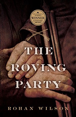
The Roving Party is a 2011 novel written by Tasmanian author Rohan Wilson. Wilson's first book, it is published by Allen & Unwin. The Roving Party won the 2011 Vogel Award. The novel was also shortlisted for the 2011 Victorian Premier's Literary Awards Vance Palmer Prize for Fiction.

<span class="mw-page-title-main">Conara, Tasmania</span> Town in Tasmania, Australia

Conara is a rural locality in the local government area (LGA) of Northern Midlands in the Central LGA region of Tasmania. The locality is about 50 kilometres (31 mi) south-east of the town of Longford. The 2016 census recorded a population of 130 for the state suburb of Conara.

The Giblin Peak is a mountain of the Ben Lomond mountain range in northeast Tasmania, Australia. It is the highest elevation on Giblin Fells, a prominent bluff south of Ben Lomond's highest elevation - Legges Tor.

References

  1. "LISTmap (Stacks Bluff)". Tasmanian Government Department of Primary Industries and Water. Retrieved 25 March 2008.
  2. 1 2 3 4 5 "Stacks Bluff, Australia". Peakbagger.com. Retrieved 7 June 2015.
  3. "Stacks Bluff (TAS)". Gazetteer of Australia online. Geoscience Australia, Australian Government.
  4. 1 2 Kee, Sue (1991). Aboriginal archaeological sites in North East Tasmania. Hobart: Occasional paper / Dept. of Parks, Wildlife and Heritage 0156-2797 ; no. 28. ISBN   0724617620.
  5. Ryan, Lyndall (2012). Tasmanian Aborigines : a history since 1803 (1 ed.). Crows Nest: Allen & Unwin. ISBN   9781742370682.
  6. 1 2 3 Taylor, John (1996). "Dictionary of Palawa place names". State Library of Tasmania/Riuwanna - UTAS: 72.
  7. Taylor, John (2006). The Palawa (Tasmanian Aboriginal) Languages: A Preliminary Discussion (MA thesis). University of Tasmania.
  8. "Country Post". No. page.2. Hobart Town Courier. 30 May 1829. Retrieved 28 November 2016.
  9. Clements, Nicholas. "The truth about John Batman: Melbourne's founder and 'murderer of the blacks'". The Conversation. Retrieved 9 September 2021.
  10. Kee, Sue (July 1991). Aboriginal Archeological Sites in North East Tasmania. Hobart, Tasmania: Commonwealth of Australia Department of Parks, Wildlife and Heritage. p. 101.
  11. Hansen, David (2003). John Glover The Van Diemen's land sketchbook. Tasmanian Museum and Art Gallery. Hobart. ISBN   09750545-3-8.
  12. "The Courier, Hobart Tas". 21 July 1843. Retrieved 6 July 2015.
  13. 1 2 3 Plomley, Brian (1988). "Eldershaw Memorial Lecture: Ben Lomond: history and science". Papers and Proceedings: Tasmanian Historical Research Association. 35 (4). ISSN   0039-9809 . Retrieved 15 January 2021.{{cite journal}}: CS1 maint: url-status (link)
  14. Marc., Hal (22 May 1897). "Ben Lomond". The Examiner. Retrieved 21 October 2015.
  15. "Perigrinations: Notes of a Trip to Ben Lomond". Tasmanian News. 15 March 1886. Retrieved 1 April 2015.
  16. 1 2 Burgess (2010). "Images in context - the stories behind the pictures" (PDF). The Spurling legacy and the emergence of wilderness photography in Tasmania. University of Tasmania (PhD thesis). Retrieved 19 August 2016.
  17. "Tasmanian Itinerary" (PDF).
  18. 'Ben Lomond'.The Examiner (Tas).06 Jan 1922.
  19. Avoca and Ben Lomond. The Mercury (Tasmania). 28 Mar 1895
  20. 1 2 The Examiner (Launceston). 'Beautiful Tasmania'. 13 May 1893.
  21. "The East Coast., Ben Lomond Without Its Mines". The Mercury. Hobart: National Library of Australia. 7 June 1888. Retrieved 8 December 2014.
  22. Daily Telegraph (Launceston). A Christmas Trip to Ben Lomond. 10 Feb 1900
  23. Willie, Wandering (sic) (18 October 1909). "Ben Lomand: A Michaelmas Trip". Daily Telegraph. Launceston: National Library of Australia. p. 3. Retrieved 8 December 2014.
  24. "A Trip to Ben Lomond". trove.nla.gov.au. The Examiner. 25 May 1983.
  25. Daily Telegraph (Launceston). A Christmas Trip to Ben Lomond. 10 Feb 1900.
  26. "Ben Lomond Southern Escarpment". Thesarvo. Retrieved 30 March 2015.
  27. Wilkinson, Bill (1994). The Abels : a comprehensive guide to Tasmania's mountains over 1100m high. Launceston: Tasmanian Outdoors Collection. ISBN   0646-216910.
  28. Ben Lomond plateau ski and walk (Map). Hobart: Tasmap; Government of Tasmania. 1988.