Mount Pelion East

Last updated

Mount Pelion East
Pelion East tree foreground.jpg
Mount Pelion East
Highest point
Elevation 1,461 m (4,793 ft) [1] [2]
Prominence 335 m (1,099 ft) [2]
Isolation 3.23 km (2.01 mi) [2]
Parent peak Mount Ossa
Listing 25th highest mountain in Tasmania
Coordinates 41°51′00″S146°03′36″E / 41.85000°S 146.06000°E / -41.85000; 146.06000 (Mount Pelion East) Coordinates: 41°51′00″S146°03′36″E / 41.85000°S 146.06000°E / -41.85000; 146.06000 (Mount Pelion East) [3]
Geography
Relief Map of Tasmania.png
Red triangle with thick white border.svg
Mount Pelion East
Location in Tasmania
Location Central Highlands, Tasmania, Australia
Parent range Pelion
Topo map Tasmap Cathedral 1:25000
Geology
Age of rock Jurassic
Mountain type Dolerite
Climbing
Easiest route Walk / hike via the Overland Track from Pelion Gap

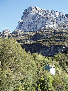
Mount Pelion East is a mountain located in the Central Highlands region of Tasmania, Australia. The mountain is situated within the Cradle Mountain-Lake St Clair National Park.

Mountain A large landform that rises fairly steeply above the surrounding land over a limited area

A mountain is a large landform that rises above the surrounding land in a limited area, usually in the form of a peak. A mountain is generally steeper than a hill. Mountains are formed through tectonic forces or volcanism. These forces can locally raise the surface of the earth. Mountains erode slowly through the action of rivers, weather conditions, and glaciers. A few mountains are isolated summits, but most occur in huge mountain ranges.

The Central Highlands is a region in Tasmania, Australia where geographical and administrative boundaries closely coincide. It is also known as The Lake Country of Tasmania.

Tasmania island state of Australia

Tasmania is an island state of Australia. It is located 240 km (150 mi) to the south of the Australian mainland, separated by Bass Strait. The state encompasses the main island of Tasmania, the 26th-largest island in the world, and the surrounding 334 islands. The state has a population of around 533,308 as of March 2019. Just over forty percent of the population resides in the Greater Hobart precinct, which forms the metropolitan area of the state capital and largest city, Hobart.

Contents

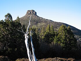
With an elevation of 1,461 metres (4,793 ft) above sea level, the mountain is the 25th highest mountain in Tasmania, slightly higher than the better known Frenchmans Cap at 1,446 metres (4,744 ft). Unlike Mount Pelion West, Pelion East is not a massive mountain, more pinnacle-like, the spire shape having been caused by harsh glacial erosion many thousands of years ago.

The Australian Height Datum is a vertical datum in Australia. According to Geoscience Australia, "In 1971 the mean sea level for 1966-1968 was assigned the value of 0.000m on the Australian Height Datum at thirty tide gauges around the coast of the Australian continent. The resulting datum surface, with minor modifications in two metropolitan areas, has been termed the Australian Height Datum (AHD) and was adopted by the National Mapping Council as the datum to which all vertical control for mapping is to be referred."

Frenchmans Cap mountain in Western Tasmania, located in Wilderness World Heritage area

The Frenchmans Cap is a mountain in the West Coast region of Tasmania, Australia. The mountain is situated in the Franklin-Gordon Wild Rivers National Park.

Mount Pelion West mountain

Mount Pelion West is a mountain located in the Central Highlands region of Tasmania, Australia. The mountain is part of the Pelion Range and is situated within the Cradle Mountain-Lake St Clair National Park at the eastern most boundary of the Murchison River catchment.

Location and access

The mountain summit is at grid reference 225655 UTM Zone 55S and high resolution topographical information is available on Tasmap Cathedral 1:25000. To the west is Mount Pelion West, due north is Lake Ayr, due east is Curate Bluff in the Cathedral Mountain range, and due south is Mount Massif. The mountain is made up of dolerite and the lower slopes are covered in low scrub, including scoparia. This mountain is approximately midway between Pelion Hut and Kia Ora Hut on the Overland Track which passes within 1,000 metres (3,300 ft) of the summit.

Tasmap is the main government authority for the state of Tasmania in Australia for the mapping and management of land information systems for the state.

Mount Massif mountain in Australia

Mount Massif is a mountain in the Central Highlands region of Tasmania, Australia. Situated in the Cradle Mountain-Lake St Clair National Park, the mountain is part of the Du Cane Range.

Overland Track hiking trail in Cradle Mountain-Lake St Clair National Park, Tasmania, Australia

The Overland Track is an Australian bushwalking track, traversing Cradle Mountain-Lake St Clair National Park, within the Tasmanian Wilderness World Heritage Area. It's walked by more than nine thousand people each year, with numbers limited in the warmer months. Officially the track runs for 65 kilometres (40 mi) from Cradle Mountain to Lake St Clair however many choose to extend it by walking along Lake St Clair for an extra day, bringing it to 82 kilometres (51 mi). It winds through terrain ranging from glacial mountains, temperate rainforest, wild rivers and alpine plains.

Mount Pelion East may be accessed via the Overland Track from Cradle Mountain during the main walking season from November to April when a booking and fee system applies. During this walking period the track is restricted to limited numbers and north-south traffic only is permitted. In the off-season, walking is also allowed from the south at Lake St Clair. Another access route is the combined Arm River and Innes Tracks which passes Lake Ayr and joins the Overland Track at Pelion Plains. A wider overview of the area and access points is available on the Tasmap Cradle Mountain-Lake St Clair map and notes publication.

Cradle Mountain mountain

Cradle Mountain is a mountain in the Central Highlands region of the Australian state of Tasmania. The mountain is situated in the Cradle Mountain-Lake St Clair National Park.

Lake St Clair (Tasmania) lake in Tasmania, Australia

Lake St Clair or leeawulenna is a natural freshwater lake located in the Central Highlands area of Tasmania, Australia. The lake forms the southern end of the Cradle Mountain-Lake St Clair National Park. It has an area of approximately 45 square kilometres (17 sq mi), and a maximum depth of 160 metres (520 ft), making it Australia's deepest lake.

This mountain can be climbed from the Overland Track which passes by very closely at Pelion Gap, at an elevation of 1,126 metres (3,694 ft).

Pelion Gap mountain pass in Tasmania, Australia

Pelion Gap is the mountain pass between Mount Doris and Mount Ossa to the south and Mount Pelion East to the north through which the Overland Track in Tasmania passes.

Mount Ossa (Tasmania) mountain in Tasmania

Mount Ossa is the highest mountain in Tasmania with a summit elevation of 1,617 metres (5,305 ft) above sea level. It makes up part of the Pelion Range within Cradle Mountain-Lake St Clair National Park in the Central Highlands region of Tasmania, Australia.

See also

Related Research Articles

Cradle Mountain-Lake St Clair National Park Protected area in Tasmania, Australia

Cradle Mountain-Lake St Clair National Park is located in the Central Highlands area of Tasmania (Australia), 165 kilometres (103 mi) northwest of Hobart. The park contains many walking trails, and is where hikes along the well-known Overland Track usually begin. Major features are Cradle Mountain and Barn Bluff in the northern end, Mount Pelion East, Mount Pelion West, Mount Oakleigh and Mount Ossa in the middle and Lake St Clair in the southern end of the park. The park is part of the Tasmanian Wilderness World Heritage Area.

Barn Bluff Mountain in Tasmania, Australia

Barn Bluff is a mountain located in the Central Highlands region of Tasmania, Australia. The mountain is situated in the Cradle Mountain-Lake St Clair National Park at the junction of the eastern most points of the Murchison and Mackintosh river catchments.

Ironstone Mountain mountain in the Central Highlands of Tasmania

The Ironstone Mountain is a mountain located in the Central Highlands region of Tasmania, Australia. Part of Great Western Tiers escarpment, the mountain is situated south of the small country village of Mole Creek.

Mount Thetis mountain in Australia

Mount Thetis is a mountain in the Central Highlands region of Tasmania, Australia. It is part of the Pelion Range and is situated within the Cradle Mountain-Lake St Clair National Park. It is a major feature of the national park, and is a popular venue with bushwalkers and mountain climbers.

Mount Anne mountain

Mount Anne is a mountain located in the Southwest National Park in south-west region of Tasmania, Australia. The mountain lies within the UNESCO World Heritage-listed Tasmanian Wilderness.

Mount Achilles (Tasmania) mountain

Mount Achilles is a mountain that is part of the Du Cane Range, located in the Cradle Mountain-Lake St Clair National Park in Tasmania, Australia. With an elevation of 1,353 metres (4,439 ft) above sea level, the peak is the 46th highest mountain in Tasmania.

Mount Ragoona mountain in Australia

Mount Ragoona, sometimes Mount Rogoonga, is a relatively high mountain in the southern region of the Walls of Jerusalem National Park in Tasmania, Australia. The mountain, with an elevation of 1,336 metres (4,383 ft) above sea level, is virtually surrounded by four large lakes; Myrtle, Meston, Louisa and Adelaide. The mountain rises from the shores of Lake Myrtle.

Cathedral Mountain (Tasmania) Mountain in Tasmania, Australia

Cathedral Mountain is a dominant mountain in the Cradle Mountain-Lake St Clair National Park in the central highlands in the state of Tasmania, Australia.

New Pelion Hut

New Pelion Hut is the largest alpine hut in the Cradle Mountain-Lake St Clair National Park in the Central Highlands of Tasmania, Australia

Old Pelion Hut

Old Pelion Hut is an alpine hut located in Cradle Mountain-Lake St Clair National Park in the Central Highlands of Tasmania. It was built for the Mount Pelion Copper Mining Company at around 1936.

Waterfall Valley Hut

Waterfall Valley Hut is located in the Cradle Mountain National Park, Tasmania, Australia. It is the most northerly of six overnight huts located along the Overland Track. It sleeps up to 32 people in a single room, which also houses tables and bench seats for cooking and eating. It is heated by a small gas heater.

Smithies Peak mountain in Tasmania, Australia

The Smithies Peak, sometimes incorrectly called Smithies Towers, is a mountain in the Central Highlands region of Tasmania, Australia. The mountain is situated in the Cradle Mountain-Lake St Clair National Park.

Pelion Range mountains in Australia

The Pelion Range is a mountain range in the Cradle Mountain-Lake St Clair National Park, Tasmania, Australia.

Skiing in Tasmania overview of skiing practiced in Tasmania

Skiing in Tasmania takes place in the high country of the state of Tasmania, Australia, during the Southern Hemisphere winter. Cross country skiing is possible within the Tasmanian Wilderness and two small downhill ski-fields have been developed at Ben Lomond and Mount Mawson.

References

  1. "LISTmap (Mount Pelion East)". Department of Primary Industries and Water. Government of Tasmania . Retrieved 29 February 2008.
  2. 1 2 3 "Mount Pelion East, Australia". Peakbagger.com. Retrieved 7 June 2015.
  3. "Mount Pelion East (TAS)". Gazetteer of Australia online. Geoscience Australia, Australian Government.