Mount Ossa is the highest mountain in Tasmania with a summit elevation of 1,617 metres (5,305 ft) above sea level. It makes up part of the Pelion Range within Cradle Mountain-Lake St Clair National Park in the Central Highlands region of Tasmania, Australia.

Mount Jukes is a mountain located on the Jukes Range, a spur off the West Coast Range, in the West Coast region of Tasmania, Australia.

The Hartz Mountains are mountains with twin peaks located in southern Tasmania, Australia. The mountains are situated 55 kilometres (34 mi) south west of Hobart, via Geeveston, and are part of the Hartz Mountains National Park. The Hartz Mountains area experiences typical south-west weather conditions. In all seasons there can be snow, high rainfall, extremes of temperature, strong winds and sudden weather changes.

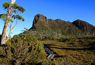
Barn Bluff is a mountain located in the Central Highlands region of Tasmania, Australia. The mountain is situated in the Cradle Mountain-Lake St Clair National Park at the junction of the easternmost points of the Murchison and Mackintosh river catchments.

The Du Cane Range is a mountain range in the Central Highlands region of Tasmania, Australia.

Mount Massif is a mountain in the Central Highlands region of Tasmania, Australia. Situated in the Cradle Mountain-Lake St Clair National Park, the mountain is part of the Du Cane Range.

Mount Geryon is a mountain in the Central Highlands region of the Australian state of Tasmania. The mountain is part of the Du Cane Range and is situated within the Cradle Mountain-Lake St Clair National Park.

King Davids Peak, also known as the West Wall, is a mountain in the Central Highlands region of Tasmania, Australia. The mountain is situated in the Walls of Jerusalem National Park.

Mount Gould is a mountain in the Central Highlands region of Tasmania, Australia. Situated within the Cradle Mountain-Lake St Clair National Park, the mountain is a major feature of the national park, and is a popular venue with bushwalkers and mountain climbers.

The Castle Crag, also known as the Falling Mountain, is a mountain in the Central Highlands region of Tasmania, Australia. The mountain is part of the Du Cane Range and is situated within the Cradle Mountain-Lake St Clair National Park. The mountain is a major feature of the national park and is a popular venue with bush walkers and mountain climbers.

Mount Thetis is a mountain in the Central Highlands region of Tasmania, Australia. It is part of the Pelion Range and is situated within the Cradle Mountain-Lake St Clair National Park. It is a major feature of the national park, and is a popular venue with bushwalkers and mountain climbers.

The Acropolis is a mountain in the Central Highlands region of Tasmania, Australia. Situated in the Cradle Mountain-Lake St Clair National Park, the mountain is part of the Du Cane Range.

Mount Anne is a mountain located in the Southwest National Park in south-west region of Tasmania, Australia. The mountain lies within the UNESCO World Heritage-listed Tasmanian Wilderness.

Mount Achilles is a mountain that is part of the Du Cane Range, located in the Cradle Mountain-Lake St Clair National Park in Tasmania, Australia. With an elevation of 1,353 metres (4,439 ft) above sea level, the peak is the 46th highest mountain in Tasmania.

Mount Victoria is a mountain in the Mount Victoria Forest Reserve in north-east Tasmania, Australia, and also forms part of the Ben Lomond biogeographic region and the Ben Lomond National Park. The peak has an elevation of 1,213 metres (3,980 ft) above sea level and is the 58th highest mountain in Tasmania. It is a prominent feature of the reserve, and is a popular venue with bushwalkers.

The Smithies Peak, sometimes incorrectly called Smithies Towers, is a mountain in the Central Highlands region of Tasmania, Australia. The mountain is situated in the Cradle Mountain-Lake St Clair National Park.

The Pelion Range is a mountain range in the Cradle Mountain-Lake St Clair National Park, Tasmania, Australia.

The Giblin Peak is a mountain of the Ben Lomond mountain range in northeast Tasmania, Australia. It is the highest elevation on Giblin Fells, a prominent bluff south of Ben Lomond's highest elevation - Legges Tor.

Markham Heights is a mountain peak that forms part of the Ben Lomond Range, in the northeast of Tasmania, Australia.


