Butlers Gorge Power Station

Last updated

Clark Dam
Clarkdam.jpg
The Clark Dam wall with the Butler Gorge Power Station located at the wall base.
Relief Map of Tasmania.png
Red pog.svg
Location of the Clark Dam in Tasmania
CountryAustralia
Location Central Highlands, Tasmania
Coordinates 42°15′36″S146°15′36″E / 42.26000°S 146.26000°E / -42.26000; 146.26000 Coordinates: 42°15′36″S146°15′36″E / 42.26000°S 146.26000°E / -42.26000; 146.26000
Purpose Power
StatusOperational
Opening date1949 (1949)
Owner(s) Hydro Tasmania
Dam and spillways
Type of dam Arch dam
Impounds Upper River Derwent
Height67 metres (220 ft)
Length378 metres (1,240 ft)
Dam volume159 thousand cubic metres (5.6×10^6 cu ft)
Spillways 1
Spillway type Controlled
Spillway capacity687 cubic metres per second (24,300 cu ft/s)
Reservoir
CreatesLake King William
Total capacity539,340 megalitres (19,047×10^6 cu ft)
Catchment area 575 square kilometres (222 sq mi)
Surface area41.45 hectares (102.4 acres)
Butlers Gorge Power Station
Coordinates 42°15′36″S146°15′36″E / 42.26000°S 146.26000°E / -42.26000; 146.26000
Operator(s) Hydro Tasmania
Commission date1951 (1951)
Type Conventional
Hydraulic head 49 metres (161 ft)
Turbines 1 x 12.20-megawatt (16,360 hp)
English Electric Francis-type turbine
Installed capacity 12.2 megawatts (16,400 hp)
Capacity factor 0.8
Annual generation 684 gigawatt-hours (2,460 TJ)
Website
hydro.com.au/energy/our-power-stations/derwent-0/butlers-gorge-power-station
[1]

The Butlers Gorge Power Station is a conventional hydroelectric power station located in the Central Highlands region of Tasmania, Australia.

Contents

Technical details

Control room (1953) Butlers Gorge Power Station, control room (1953) (14308132868).jpg
Control room (1953)

Part of the Derwent scheme that comprises eleven hydroelectric power stations, the Butlers Gorge Power Station is the first station in the scheme. The power station is located aboveground at the foot of the concrete arched Clark Dam across the River Derwent that forms Lake King William. Water from the lake is fed to the power station, coupled to one of two discharge regulating valves to ensure water flow to Tarraleah Power Station located further downstream. [2] [3]

The power station was commissioned in 1951 by the Hydro Electric Corporation (TAS) and officially opened on 22 November 1952. The station has one English Electric Francis turbine, with a generating capacity of 12.2 megawatts (16,400 hp) of electricity. The station building houses a single alternator and the turbine has a fully embedded spiral casing with water flow controlled via a butterfly type valve. It also houses a 125 kVA diesel generator for alternate station services supply when needed. The station output, estimated to be 684 gigawatt-hours (2,460 TJ) annually, [1] is fed to TasNetworks' transmission grid via an 11 kV/110 kV three-phase English Electric generator transformer to the outdoor switchyard. [2]

The water discharged from the Butlers Gorge Power Station flows via three conduits to either Nieterana mini-hydro, Tarraleah Power Station, or to Wally's Weir and back into the Derwent. [3]

Climate

Butlers Gorge has a temperate oceanic climate (Köppen: Cfb), bordering on a subpolar oceanic climate (Köppen: Cfc). Over the period 1957 to 1993, there were on average 27 snow days annually. [4]

Climate data for Butlers Gorge 1991–2020 (extremes 1941–2022)
MonthJanFebMarAprMayJunJulAugSepOctNovDecYear
Record high °C (°F)34.4
(93.9)
33.5
(92.3)
31.9
(89.4)
25.0
(77.0)
22.0
(71.6)
18.3
(64.9)
16.1
(61.0)
18.9
(66.0)
24.4
(75.9)
26.8
(80.2)
30.3
(86.5)
32.7
(90.9)
34.4
(93.9)
Average high °C (°F)19.3
(66.7)
19.1
(66.4)
16.9
(62.4)
13.5
(56.3)
10.4
(50.7)
8.5
(47.3)
7.7
(45.9)
8.2
(46.8)
10.4
(50.7)
13.5
(56.3)
15.7
(60.3)
17.3
(63.1)
13.4
(56.1)
Average low °C (°F)6.7
(44.1)
6.2
(43.2)
5.4
(41.7)
3.7
(38.7)
2.1
(35.8)
0.7
(33.3)
0.2
(32.4)
0.2
(32.4)
1.4
(34.5)
2.4
(36.3)
4.4
(39.9)
5.6
(42.1)
3.2
(37.8)
Record low °C (°F)−2.8
(27.0)
−2.5
(27.5)
−4.4
(24.1)
−5.7
(21.7)
−6.7
(19.9)
−13.0
(8.6)
−12.5
(9.5)
−12.2
(10.0)
−6.5
(20.3)
−5.7
(21.7)
−5.5
(22.1)
−3.3
(26.1)
−13.0
(8.6)
Average rainfall mm (inches)90.0
(3.54)
77.9
(3.07)
109.6
(4.31)
132.7
(5.22)
165.2
(6.50)
135.8
(5.35)
186.0
(7.32)
232.9
(9.17)
168.6
(6.64)
152.9
(6.02)
127.9
(5.04)
123.0
(4.84)
1,706.7
(67.19)
Average rainy days16.112.517.220.822.822.625.025.423.321.520.018.6245.8
Source: Bureau of Meteorology (1991–2020 averages; [5] extremes 1941–present) [6]

See also

Related Research Articles

The Bastyan Power Station is a conventional hydroelectric power station located in Western Tasmania, Australia.

The Mackintosh Power Station is a conventional hydroelectric power station located in Western Tasmania, Australia.

The Reece Power Station is a conventional hydroelectric power station located in the West Coast region of Tasmania, Australia.

The Tribute Power Station is a conventional hydroelectric power station located in Western Tasmania, Australia.

<span class="mw-page-title-main">Tarraleah Power Station</span> Dam in Central Highlands, Tasmania

The Tarraleah Power Station is a hydroelectric power station located in the Central Highlands region of Tasmania, Australia. The power station is part of the Upper Derwent hydro scheme and is operated by Hydro Tasmania.

The Catagunya Power Station is a run-of-the-river hydroelectric power station located in the Central Highlands region of Tasmania, Australia. The power station is situated on the Lower River Derwent catchment and is owned and operated by Hydro Tasmania.

<span class="mw-page-title-main">Liapootah Power Station</span> Power station in Central Highlands Tasmania

The Liapootah Power Station is a run-of-the-river hydroelectric power station located in the Central Highlands region of Tasmania, Australia. The power station is situated on the Lower River Derwent catchment and is owned and operated by Hydro Tasmania.

The Wayatinah Power Station is a run-of-the-river hydroelectric power station located in the Central Highlands region of Tasmania, Australia. The power station is situated on the Lower River Derwent catchment and is owned and operated by Hydro Tasmania.

The Repulse Power Station is a conventional hydroelectric power station located in the Central Highlands region of Tasmania, Australia. The power station is situated on the Lower River Derwent catchment and is owned and operated by Hydro Tasmania.

The Cluny Power Station is a conventional hydroelectric power station located in the Central Highlands region of Tasmania, Australia. The power station is situated on the Lower River Derwent catchment and is owned and operated by Hydro Tasmania.

<span class="mw-page-title-main">Meadowbank Power Station</span> Power station in Tasmania, Australia

The Meadowbank Power Station is a run-of-the-river hydroelectric power station located in the Central Highlands region of Tasmania, Australia. The power station is situated on the Lower River Derwent catchment and is owned and operated by Hydro Tasmania.

<span class="mw-page-title-main">Tungatinah Power Station</span> Power station in Tasmania, Australia

The Tungatinah Power Station is a conventional hydroelectric power station located in the Central Highlands region of Tasmania, Australia. The power station is situated on the Upper River Derwent catchment and is owned and operated by Hydro Tasmania.

The Lake Echo Power Station is a conventional hydroelectric power station located in the Central Highlands region of Tasmania, Australia. The power station is situated on the Upper River Derwent catchment and is owned and operated by Hydro Tasmania.

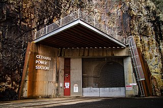
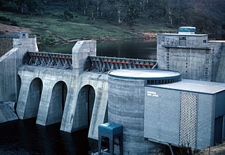
The Cethana Power Station is a conventional hydroelectric power station located in north-western Tasmania, Australia.

The Fisher Power Station is a conventional hydroelectric power station located in north-western Tasmania, Australia.

The Lemonthyme Power Station is a conventional hydroelectric power station located in north-western Tasmania, Australia. It is the third station in the Mersey–Forth run-of-river scheme that comprises seven conventional hydroelectric power stations and one mini hydro station.

The Wilmot Power Station is a conventional hydroelectric power station located in north-western Tasmania, Australia.

<span class="mw-page-title-main">Trevallyn Power Station</span> Dam in Northern Midlands Tasmania

The Trevallyn Power Station is a run-of-the-river hydroelectric power station located in the northern Midlands region of Tasmania, Australia. The power station is situated on the Great Lake and South Esk catchment and is owned and operated by Hydro Tasmania.

The John Butters Power Station is a conventional hydroelectric power station located in Western Tasmania, Australia. The power station forms part of the King – Yolande River Power Scheme and is owned and operated by Hydro Tasmania.

<span class="mw-page-title-main">Nieterana Power Station</span> Dam in Central Highlands, Tasmania

The Nieterana Power Station is a small hydroelectric power station located in the Central Highlands region of Tasmania, Australia.

References

  1. 1 2 "Register of Large Dams in Australia" (Excel (requires download)). Dams information. Australian National Committee on Large Dams. 2010. Retrieved 23 June 2015.
  2. 1 2 "Butlers Gorge Power Station: Technical fact sheet" (PDF). Derwent Catchment. Hydro Tasmania. Archived from the original (PDF) on 24 March 2012. Retrieved 4 July 2015.
  3. 1 2 "Derwent: Butlers Gorge Power Station". Energy. Hydro Tasmania. Archived from the original on 6 July 2015. Retrieved 4 July 2015.
  4. Australian Weather News. "Annual snow days sorted in descending order of average occurrence". Australian Weather News. Retrieved 8 December 2022.
  5. "Climate Statistics for Butlers Gorge". Bureau of Meteorology. Retrieved 8 December 2022.
  6. "Climate Statistics for Butlers Gorge". Bureau of Meteorology. Retrieved 8 December 2022.