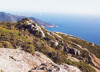
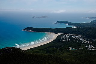
Wilsons Promontory, also known as Yiruk and Wamoon in the Gunai and Boonwurrung languages respectively, is a peninsula that forms the southernmost part of the Australian mainland, located in the state of Victoria.
Cliffy Island is an island peak, of a submerged granite mountain approximately 20 km off the coast of Victoria, Australia. It is the home of the Cliffy Island Lighthouse which is only accessible by helicopter. The island is part of the Wilsons Promontory Islands Important Bird Area, identified as such by BirdLife International because of its importance for breeding seabirds.

Rodondo Island is a granite island, part of the Rodondo Group, lying in northern Bass Strait, within the state boundaries of Tasmania, Australia. The island is located only 10 kilometres (6.2 mi) south of Wilsons Promontory in Victoria, and 2' of latitude south of the Victoria-Tasmania border at latitude 39°12'S. Rodondo Island is ringed by steep cliffs up to 200 metres (660 ft) high, with an area of 106 hectares and a maximum elevation of 350 metres (1,150 ft) above sea level.
Anser Island lies off the southern tip of Wilsons Promontory in Victoria, Australia.
Norman Island, an oceanic island, is located approximately 4 kilometres (2.5 mi) west of Picnic Point, Wilsons Promontory in Victoria, Australia.

The Shellback Island, an oceanic island, is approximately 4 kilometres (2.5 mi) northwest of Darby Bay, off Wilsons Promontory in Victoria, Australia.

Deal Island, the largest island of the Kent Group, is a 1,576-hectare (3,890-acre) granite island, located in northern Bass Strait, that lies between the Furneaux Group, north-east of Tasmania, and Wilsons Promontory, in Victoria, Australia.
West Moncoeur Island is a granite island, ringed by steep cliffs, with an area of 9.18 ha, in south-eastern Australia. It is part of Tasmania’s Rodondo Group, lying in northern Bass Strait south of Wilsons Promontory in Victoria. It is a nature reserve.
East Moncoeur Island is a granite island, with an area of 14 ha.
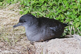
The Wilsons Promontory Islands Important Bird Area comprises a loose cluster of 19 small, granite islands, with a collective area of 658 ha, scattered around Wilsons Promontory in the state of Victoria, south-eastern Australia. The three southernmost islands are part of the state of Tasmania. They are important for their breeding seabirds.
The Wilsons Promontory Marine National Park is a protected marine national park located in the South Gippsland region of Victoria, Australia. The 15,500-hectare (38,000-acre) marine park is situated off the southern tip of Wilsons Promontory and extends along the coastline from Norman Bay, near Tidal River, in the west around the southern tip of the promontory to Cape Wellington in the east. It extends offshore to the Glennie and Anser groups of offshore islands.
Dannevig Island is a small, rugged, granite island in the Glennie group of islands off the west coast of Wilsons Promontory, Victoria, Australia. It is part of the Wilsons Promontory Islands Important Bird Area, identified as such by BirdLife International because of its importance for breeding seabirds.
Great Glennie Island is a small, rugged, granite island in the Glennie group of islands off the west coast of Wilsons Promontory, Victoria, Australia. It is part of the Wilsons Promontory Islands Important Bird Area, identified as such by BirdLife International because of its importance for breeding seabirds.
McHugh Island is a small, rugged, granite island in the Glennie group of islands off the west coast of Wilsons Promontory, Victoria, Australia. It is part of the Wilsons Promontory Islands Important Bird Area, identified as such by BirdLife International because of its importance for breeding seabirds.
Notch Island is a small granite island in the Seal Islands group approximately 20 km east of Wilsons Promontory, Victoria, Australia. It is part of the Wilsons Promontory Islands Important Bird Area, identified as such by BirdLife International because of its importance for breeding seabirds.
Rag Island is a small granite island in the Seal Islands group approximately 20 km east of Wilsons Promontory, Victoria, Australia. It is part of the Wilsons Promontory Islands Important Bird Area, identified as such by BirdLife International because of its importance for breeding seabirds.
Seal Island is a small granite island in the Seal Islands group approximately 15 km east of Wilsons Promontory, Victoria, Australia. It is part of the Wilsons Promontory Islands Important Bird Area, identified as such by BirdLife International because of its importance for breeding seabirds.
Rabbit Island is a small, granite island 1.6 km off the north-eastern coast of Wilsons Promontory, Victoria, Australia.
Rabbit Rock is a small, granite island 200 m off the north-eastern coast of Wilsons Promontory, Victoria, Australia. It is part of the Wilsons Promontory Islands Important Bird Area, identified as such by BirdLife International because of its importance for breeding seabirds.
Wattle Island, is a small, granite island located approximately 0.5 kilometres (0.31 mi) south of Wilsons Promontory in Victoria, Australia.

