The Croajingolong National Park is a coastal national park located in the East Gippsland region of the Australian state of Victoria. The 88,355-hectare (218,330-acre) national park is situated approximately 450 kilometres (280 mi) east of Melbourne and 500 kilometres (310 mi) south of Sydney.

Carmarthen Bay is an inlet of the South Wales coast, including notable beaches such as Pendine Sands and Cefn Sidan sands. Carmarthen Bay is partially within the Pembrokeshire Coast National Park. The Joint Nature Conservation Committee list Carmarthen Bay and Estuaries as a Special Area of Conservation.

Terra Nova Bay is a bay which is often ice free, about 64 km (40 mi) long, lying between Cape Washington and the Drygalski Ice Tongue along the coast of Victoria Land, Antarctica. It was discovered by the British National Antarctic Expedition under Robert Falcon Scott, 1901–1904, and named by him after Terra Nova, one of the relief ships for the expedition. The Italian permanent Zucchelli Station is located in the bay, as is the Jang Bogo Station of South Korea. Relief Inlet can be found in the south west corner of the Bay.

The Ninety Mile Beach is a sandy stretch of beach on the south-eastern coastline of the East Gippsland region of Victoria in Australia. The beach faces Bass Strait and backs the Gippsland Lakes. The beach is just over 151 kilometres (94 mi) in length, running north-eastward from a spit near Port Albert to the man-made channel at Lakes Entrance.

Port Renfrew is a small unincorporated community located on the south shore of Port San Juan, an inlet on the west coast of Vancouver Island in British Columbia, Canada. Port Renfrew has a population of 144 and has been touted as "the Tall Tree Capital of Canada".

Sunday Island is a low-lying, sandy, 16.2 km2 barrier island on the coast of Victoria, Australia. It is about 8 km long by 3 km wide and rises to a maximum height of no more than 15 m above mean sea level. It lies in Corner Inlet, South Gippsland, 4 km south-west of Port Albert and 215 km south-east of Melbourne. Although the island is surrounded by the Nooramunga Marine and Coastal Park, it is private freehold property, a game reserve owned by the Para Park Co-operative Game Reserve Limited. It contains an airstrip and a jetty as well as accommodation buildings for resident caretakers, visiting members, and their guests.

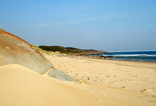
Bennison Island is an uninhabited granite island in Corner Inlet near the northern coast of Wilsons Promontory, in Victoria, Australia.
Kyuquot Sound is a complex of coastal inlets, bays and islands on northwestern Vancouver Island in the Canadian province of British Columbia.

Nornalup Inlet is an estuarine body of water on the south coast of the South West of Australia, approximately 450 km (280 mi) from Perth.
Yanakie is a small, coastal township and district on the Yanakie Isthmus in South Gippsland, in the state of Victoria, south-eastern Australia.
Snake Island is a sand island, located in Corner Inlet in the Gippsland region of Victoria, Australia. It has an area of 35-square-kilometre (14 sq mi) and is the largest island in Corner Inlet. Snake Island lies within the Nooramunga Marine and Coastal Park and is part of a complex of barrier islands that protect a large marine embayment from the pounding waves of Bass Strait. The Aboriginal Gunai name for the island is Negima.

The Corner Inlet is a 600-square-kilometre (230 sq mi) bay located 200 kilometres (120 mi) south-east of Melbourne in the South Gippsland region of Victoria, Australia. Of Victoria's large bays it is both the easternmost and the warmest. It contains intertidal mudflats, mangroves, salt marsh and seagrass meadows, sheltered from the surf of Bass Strait by a complex of 40 sandy barrier islands, the largest of which are Snake, Sunday and Saint Margaret Islands.
The Corner Inlet Marine National Park is a protected marine national park located in the South Gippsland region of Victoria, Australia. The 1,550-hectare (3,800-acre) marine park is situated approximately 200 kilometres (120 mi) southeast of Melbourne and contains part of Corner Inlet.
The Wilsons Promontory Marine National Park is a protected marine national park located in the South Gippsland region of Victoria, Australia. The 15,500-hectare (38,000-acre) marine park is situated off the southern tip of Wilsons Promontory and extends along the coastline from Norman Bay, near Tidal River, in the west around the southern tip of the promontory to Cape Wellington in the east. It extends offshore to the Glennie and Anser groups of offshore islands.
Batiquitos Lagoon State Marine Conservation Area (SMCA) is a marine protected area in San Diego on California’s south coast. It is part of Batiquitos Lagoon, a coastal tidal wetland lying within the city limits of Carlsbad, California and adjacent to Encinitas, California. The SMCA covers 2000 miles. The SMCA protects marine life by limiting the removal of marine wildlife from within its borders.
Clonmel Island is a sand island in Corner Inlet, in the Gippsland region of Victoria, Australia. Clonmel Island lies within the Nooramunga Marine and Coastal Park and is part of a complex of barrier islands that protect a large marine embayment from the pounding waves of Bass Strait.
Granite Island is a small, uninhabited granite island in Corner Inlet near the northern coast of Wilsons Promontory, in Victoria, Australia.

Muir Inlet is an inlet in Glacier Bay, U.S.A. Muir Inlet heads in Muir Glacier, and extends for 48 kilometers (30 mi) south to Glacier Bay, 51 miles (82 km) NW of Hoonah, Alaska Muir Inlet is separated from Chilkat Inlet and Lynn Canal by Chilkat Range. Muir Inlet has several glacier's terminuses besides Muir Glacier, most prominent are Casement Glacier, McBride Glacier and Riggs Glacier. In the west lies the Wachusett Inlet and in the east the Adam's Inlet.

Hardy Island is an island of the Northern Gulf Islands archipelago located in the Sunshine Coast region of British Columbia.

Westhaven Marine Reserve is a marine reserve covering an area of 536 hectares in the Whanganui Inlet at the top of New Zealand's South Island. It was established in 1994 and is administered by the Department of Conservation.
