
The Ninety Mile Beach is a sandy stretch of beach on the south-eastern coastline of the East Gippsland region of Victoria in Australia. The beach faces Bass Strait and backs the Gippsland Lakes. The beach is just over 151 kilometres (94 mi) in length, running north-eastward from a spit near Port Albert to the man-made channel at Lakes Entrance.
Seymour Inlet is one of the lesser travelled of the principal inlets of the British Columbia Coast. Unlike larger inlets such as Knight or Bute, it is not flanked by mountains but by relatively low, but still rugged, coastal hill-country and forms a maze of complex, narrow waterways and tidal pools and lagoons. It is located within a corresponding maze of peninsulas on the mainland on the northwest side of the Queen Charlotte Strait region.

Saanich Inlet is a body of salt water that lies between the Saanich Peninsula and the Malahat highlands of Vancouver Island, British Columbia, Canada. Located just northwest of Victoria, the inlet is 25 km (16 mi) long, has a surface area of 67 km2 (26 sq mi), and its maximum depth is 226 m (741 ft). It extends from Satellite Channel in the north to Squally Reach and Finlayson Arm in the south. The only major tributary feeding the inlet is the Goldstream River.

Sunday Island is a low-lying, sandy, 16.2 km2 barrier island on the coast of Victoria, Australia. It is about 8 km long by 3 km wide and rises to a maximum height of no more than 15 m above mean sea level. It lies in Corner Inlet, South Gippsland, 4 km south-west of Port Albert and 215 km south-east of Melbourne. Although the island is surrounded by the Nooramunga Marine and Coastal Park, it is private freehold property, a game reserve owned by the Para Park Co-operative Game Reserve Limited. It contains an airstrip and a jetty as well as accommodation buildings for resident caretakers, visiting members, and their guests.

Bennison Island is an uninhabited granite island in Corner Inlet near the northern coast of Wilsons Promontory, in Victoria, Australia.
Norman Island, an oceanic island, is located approximately 4 kilometres (2.5 mi) west of Picnic Point, Wilsons Promontory in Victoria, Australia.

The Shellback Island, an oceanic island, is approximately 4 kilometres (2.5 mi) northwest of Darby Bay, off Wilsons Promontory in Victoria, Australia.
Corner Island is located in Corner Inlet Marine National Park, approximately 2.5 kilometres (1.6 mi) north of Millers Landing on Wilsons Promontory in Victoria, Australia. The island is accessible only at high tide by boat.
Doughboy Island may refer to:
Quatsino Sound is a complex of coastal inlets, bays and islands on northwestern Vancouver Island in the Canadian province of British Columbia. It is the northernmost of the five sounds that pierce the west coast of Vancouver Island, the others being Kyuquot Sound, Nootka Sound, Clayoquot Sound, and Barkley Sound.
Snake Island is a sand island, located in Corner Inlet in the Gippsland region of Victoria, Australia. It has an area of 35-square-kilometre (14 sq mi) and is the largest island in Corner Inlet. Snake Island lies within the Nooramunga Marine and Coastal Park and is part of a complex of barrier islands that protect a large marine embayment from the pounding waves of Bass Strait. The Aboriginal Gunai name for the island is Negima.

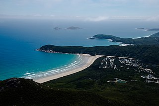
The Corner Inlet is a 600-square-kilometre (230 sq mi) bay located 200 kilometres (120 mi) south-east of Melbourne in the South Gippsland region of Victoria, Australia. Of Victoria's large bays it is both the easternmost and the warmest. It contains intertidal mudflats, mangroves, salt marsh and seagrass meadows, sheltered from the surf of Bass Strait by a complex of 40 sandy barrier islands, the largest of which are Snake, Sunday and Saint Margaret Islands.
Saint Margaret Island lies in Corner Inlet, in the Gippsland region of Victoria, Australia. It lies at the eastern end of the Nooramunga Marine and Coastal Park, close to Ninety Mile Beach.

The Electoral district of Alberton was an electoral district of the Legislative Assembly in the Australian colony of Victoria, located in the south-east of the then-colony.
The Corner Inlet Marine National Park is a protected marine national park located in the South Gippsland region of Victoria, Australia. The 1,550-hectare (3,800-acre) marine park is situated approximately 200 kilometres (120 mi) southeast of Melbourne and contains part of Corner Inlet.
The Wilsons Promontory Marine National Park is a protected marine national park located in the South Gippsland region of Victoria, Australia. The 15,500-hectare (38,000-acre) marine park is situated off the southern tip of Wilsons Promontory and extends along the coastline from Norman Bay, near Tidal River, in the west around the southern tip of the promontory to Cape Wellington in the east. It extends offshore to the Glennie and Anser groups of offshore islands.
Clonmel Island is a sand island in Corner Inlet, in the Gippsland region of Victoria, Australia. Clonmel Island lies within the Nooramunga Marine and Coastal Park and is a part of a complex of barrier islands that protect a large marine embayment from the pounding waves of Bass Strait.
Rabbit Island is a small, granite island 1.6 km off the north-eastern coast of Wilsons Promontory, Victoria, Australia.
Wattle Island, is a small, granite island located approximately 0.5 kilometres (0.31 mi) south of Wilsons Promontory in Victoria, Australia.
Granite Island is a small, uninhabited granite island in Corner Inlet near the northern coast of Wilsons Promontory, in Victoria, Australia.
