The northern gannet is a seabird, the largest species of the gannet family, Sulidae. It is native to the coasts of the Atlantic Ocean, breeding in Western Europe and Northeastern North America. It is the largest seabird in the northern Atlantic. The sexes are similar in appearance. The adult northern gannet has a mainly white streamlined body with a long neck, and long and slender wings. It is 87–100 cm long with a 170–180 cm (67–71 in) wingspan. The head and nape have a buff tinge that is more prominent in breeding season, and the wings are edged with dark brown-black feathers. The long, pointed bill is blue-grey, contrasting with black, bare skin around the mouth and eyes. Juveniles are mostly grey-brown, becoming increasingly white in the five years it takes them to reach maturity.

The Australasian gannet, also known as the Australian gannet or tākapu, is a large seabird of the booby and gannet family, Sulidae. Adults are mostly white, with black flight feathers at the wingtips and lining the trailing edge of the wing. The central tail feathers are also black. The head is tinged buff-yellow, with a pearly grey bill edged in dark grey or black, and blue-rimmed eyes. Young birds have mottled plumage in their first year, dark above and light below. The head is an intermediate mottled grey, with a dark bill. The birds gradually acquire more white in subsequent seasons until they reach maturity after five years.

Pedra Branca is a rock islet in the Southern Ocean, off the southern coast of Tasmania, Australia. The island is situated approximately 26 km (16 mi) south southeast of South East Cape and is contained within the Southwest National Park, part of the Tasmanian Wilderness World Heritage Site. An erosional remnant of the Tasmanian mainland, the island is approximately 270 m (890 ft) long, 100 m (330 ft) wide, with an elevation of 60 m (200 ft) above sea level. The island is estimated to have separated from the Tasmanian mainland at least 15,000 years ago.
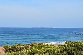
Lady Julia Percy Island, known as Deen Maar or Dhinmar in the Gunditjmara language, lies 8.1 kilometres (5.0 mi) off the coast, in the Barwon South West region of Victoria, Australia in Bass Strait. The island is an unincorporated area under the direct administration of the government of Victoria.

Pope's Eye is the uncompleted foundation for an island fort intended to defend the entrance to Port Phillip in the state of Victoria, Australia. The undefined area of the fort, generally assessed at 4 hectares, is one of six separate areas that comprise the Port Phillip Heads Marine National Park and is a popular site for divers.

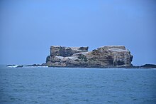
Black Pyramid Rock is an island nature reserve, with an area of 40 ha, in Bass Strait, south-eastern Australia. It is part of Tasmania’s Hunter Island Group which lies between north-west Tasmania and King Island. It is part of the Albatross Island and Black Pyramid Rock Important Bird Area. It is notable for its Australasian gannet colony which, at over 12,000 pairs, is the largest in Tasmania and supports about 20% of the world population of the species.

Curtis Island is a granite island, with an area of 150 ha, in south-eastern Australia. It is part of Tasmania’s Curtis Group, lying in northern Bass Strait between the Furneaux Group and Wilsons Promontory in Victoria. It is a nature reserve and has been identified as an Important Bird Area because it supports up to 390,000 breeding pairs of short-tailed shearwaters or Tasmanian muttonbirds.
West Moncoeur Island is a granite island, ringed by steep cliffs, with an area of 9.18 ha, in south-eastern Australia. It is part of Tasmania’s Rodondo Group, lying in northern Bass Strait south of Wilsons Promontory in Victoria. It is a nature reserve.
East Moncoeur Island is a granite island, with an area of 14 ha.

The Cat Island, part of the Babel Group within the Furneaux Group, is a 39-hectare (96-acre) unpopulated granite island, located in Bass Strait, lying off the east coast of Flinders Island, Tasmania, south of Victoria, in south-eastern Australia.

The Cape-Pigeon Rocks are twin rocky promontories on the western side of Watt Bay, 6 kilometres (3 nmi) south of Garnet Point. They were discovered by the Australasian Antarctic Expedition (1911–14) under Douglas Mawson, who gave the name because of the large rookery of Cape petrels here. The Advisory Committee on Antarctic Names added a hyphen between the first and second words in the specific part of the name to reduce ambiguity and emphasize the generic term "Rocks".

The Eden Rocks are two rocks lying 1.5 km off the east coast of Dundee Island, at the northern end of the Antarctic Peninsula. A small island was reported there on 30 December 1842 by Captain James Clark Ross of the Royal Navy, who named it "Eden Island" for Captain Charles Eden. Following a survey by the Falkland Islands Dependencies Survey in 1953, it was reported that the feature consists of two rocky islets rising to about 90 m in height and lying close together.
Haswell Island is the largest of the Haswell Islands, lying off the coast of Antarctica, about 3 kilometres (1.5 nmi) north of Mabus Point in Queen Mary Land. It was discovered by the Western Base Party of the Australasian Antarctic Expedition, 1911–14, under Mawson, and named by him for Professor William A. Haswell, a zoologist at Sydney University and a member of the expedition's Advisory Committee.

The Mackellar Islands, also MacKellar Islets, are a group of about 30 small islands and rocks lying 3 kilometres (1.5 nmi) north of Cape Denison in the center of Commonwealth Bay, George V Land, Antarctica. They were discovered by the Australasian Antarctic Expedition (1911–14) under Douglas Mawson, who named them for C.D. Mackellar of London, a patron of the expedition. The largest is Greater Mackellar Island.

Higginson Island is a small island in the Arafura Sea lying off the north-eastern coast of Arnhem Land, in the Northern Territory of Australia. It is one of the East Bremer Islets, lying to the north and east of the much larger Bremer Island.

The Low Rocks and Sterna Island Important Bird Area comprises two islets lying about 14 km apart and with a collective area of 14 ha, in the Montesquieu group of islands, in the mouth of Admiralty Gulf in the Kimberley region of Western Australia.

The Phillip Island Important Bird Area comprises a 20 km2 strip of coastline along the south and west coasts of Phillip Island, Victoria, in south-eastern Australia.

The Swan Bay and Port Phillip Bay Islands Important Bird Area comprises a cluster of disparate sites centred at the eastern end of the Bellarine Peninsula, and the southern end of Port Phillip, in Victoria, south-eastern Australia. As well as providing core wintering habitat for orange-bellied parrots, it is important for waders, or shorebirds, and seabirds.

Point Danger is a headland on the coast of south-western Victoria, Australia. It lies at the western end of Portland Bay, on the northern side of Bass Strait, about 6 km south-south-east of the city of Portland. Cape Nelson lies 2.5 km to the south-west and the Lawrence Rocks 2 km to the south-east.
Seal Rocks comprises two small islets – Seal Rock and Black Rock – 1.5 kilometres (0.9 mi) south-west of Phillip Island in Victoria, Australia at the western entrance to Western Port.