| Ripon Victoria—Legislative Assembly | |||||||||||||||
|---|---|---|---|---|---|---|---|---|---|---|---|---|---|---|---|
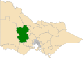
Interactive map of electoral district boundaries from the 2022 state election | |||||||||||||||
| State | Victoria | ||||||||||||||
| Dates current | 1945–1955 1976–present | ||||||||||||||
| MP | Martha Haylett | ||||||||||||||
| Party | Labor | ||||||||||||||
| Namesake | Shire of Ripon | ||||||||||||||
| Electors | 47,774 (2018) | ||||||||||||||
| Area | 14,444 km2 (5,576.9 sq mi) | ||||||||||||||
| Demographic | Rural | ||||||||||||||
| Coordinates | 36°57′0″S143°15′36″E / 36.95000°S 143.26000°E | ||||||||||||||
| |||||||||||||||

Ripon is a single member electoral district of the Victorian Legislative Assembly. It is a rural electorate based in western Victoria. In 1946 the electoral district of Ripon was first contested but then abolished in the 1955 election after being held by Labor for seven of these years. [1] Ripon was re-created in 1976, [1] essentially as a replacement for Hampden and Kara Kara.
Contents
Ripon has an area of 16,761 square kilometres. [2] It includes the towns of Amphitheatre, Ararat, Avoca, Bealiba, Beaufort, Borung, Bridgewater on Loddon, Buangor, Cardigan, Carisbrook, Charlton, Clunes, Creswick, Dunolly, Eddington, Elmhurst, Glenorchy, Great Western, Inglewood, Landsborough, Lexton, Lucas, Marnoo, Maryborough, Miners Rest, Moonambel, Newbridge, Snake Valley, St Arnaud, Stawell, Stuart Mill, Talbot, Tarnagulla and Wedderburn. [2] The main population centres are Creswick, Ararat, Maryborough, Beaufort, Avoca, Bridgewater on Loddon, St Arnaud and Stawell. [1] This district is known for agriculture, wine making, timber industries, manufacturing, wool production, paper milling, knitting mills and tourism. [2]
It has been held by the Liberal Party for most of its history. However, it was one of several country seats that unexpectedly fell to Labor Party in 1999 as part of Labor's shock victory that year. Labor would hold the seat until 2014, and reclaimed it in 2022. The 2018 result was the subject of a legal challenge by the second placed Labor candidate. [3]
In the 2021 redistribution, the boundaries of Ripon moved southeast, losing Donald and Charlton to Mildura, and Stawell to Lowan, and also gaining rural towns to the north, west and southwest of Ballarat from the abolished district of Buninyong. As a result, it is estimated that Ripon would be a Labor marginal seat from results of the 2018 election with a margin of 2.8%. [4]