Related Research Articles
Electoral district of Korong and Eaglehawk was an electoral district of the Legislative Assembly in the Australian state of Victoria.
The Electoral district of Wangaratta was an electoral district of the Victorian Legislative Assembly. It was created in the redistribution of 1904, the Electoral district of Wangaratta and Rutherglen being abolished.
The Electoral district of Kara Kara and Borung was an electoral district of the Victorian Legislative Assembly.

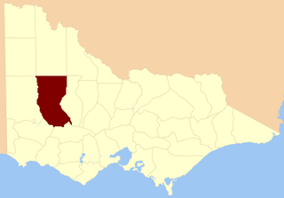
The Shire of Donald was a local government area about 140 kilometres (87 mi) west-northwest of Bendigo, in western Victoria, Australia. The shire covered an area of 1,448 square kilometres (559.1 sq mi), and existed from 1861 until 1995.
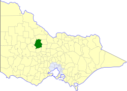
The Shire of Korong was a local government area about 75 kilometres (47 mi) west-northwest of Bendigo, in western Victoria, Australia. The shire covered an area of 238.5 square kilometres (92.1 sq mi), and existed from 1862 until 1995.

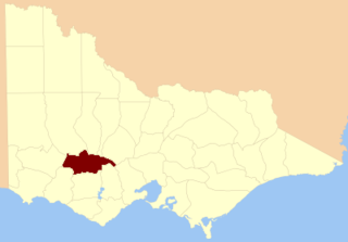
The Shire of Warracknabeal was a local government area about 200 kilometres (124 mi) west-northwest of Bendigo and 60 kilometres (37 mi) north of Horsham, in western Victoria, Australia. The shire covered an area of 1,839 square kilometres (710.0 sq mi), and existed from 1891 until 1995.

The County of Lowan is one of the 37 counties of Victoria which are part of the cadastral divisions of Australia, used for land titles. The northern boundary of the county is at 36°S. Larger towns include Dimboola, Edenhope and Kaniva. The county was proclaimed in 1871 together with the other counties of the Wimmera Land District.
The County of Borung is one of the 37 counties of Victoria which are part of the cadastral divisions of Australia, used for land titles. The northern boundary of the county is at 36°S. At the north its western boundary is 142°E, its eastern boundary is 143°E. Larger towns include Dimboola, Warracknabeal, Horsham and Stawell. The county was proclaimed in 1871 together with the other counties of the Wimmera Land District. The county was proclaimed in 1871.

The County of Kara Kara is one of the 37 counties of Victoria which are part of the cadastral divisions of Australia, used for land titles. The northern boundary of the county is at 36°S. At the north its western boundary is 143°E. Larger towns include St Arnaud and Donald. The County was proclaimed in 1871 together with the other counties of the Wimmera Land District.
The County of Ripon is one of the 37 counties of Victoria which are part of the cadastral divisions of Australia, used for land titles. The county includes the plains of the Western District from Ballarat in the east to the Grampians in the west. Larger towns include Beaufort. The county was proclaimed in 1849.
Ballarat was an electoral district of the Legislative Assembly in the Australian state of Victoria. It was created in the redistribution preceding the 1927 election, its area mainly consisting of the former districts of Ballarat West and Ballarat East.
The electoral district of Borung was an electorate of the Victorian Legislative Assembly in the Australian colony of Victoria, which existed in two incarnations, from 1889 to 1927, and then from 1945 to 1955.

Polwarth, Ripon, Hampden and South Grenville was an electoral district of the Legislative Assembly in the Australian state of Victoria from 1856 to 1859. It was based in western Victoria.
Crowlands was an electoral district of the Legislative Assembly in the Australian colony of Victoria from 1859 to 1877. It was located in north-western Victoria and included the town of Swan Hill.
Glenelg was an electoral district of the Legislative Assembly in the Australian state of Victoria based in far south-western Victoria from 1904 to 1927.

Grenville was an electoral district of the Legislative Assembly in the Australian state of Victoria from 1859 to 1927. It was located in western Victoria, south of Ballarat.

Ripon and Hampden was an electoral district of the Legislative Assembly in the Australian state of Victoria from 1859 to 1904. It was based in western Victoria.
The Electoral district of Ballarat was an electoral district of the old unicameral Victorian Legislative Council of 1851 to 1856. Victoria being a colony in Australia at the time. Ballaarat was added to the Council in 1855, along with four other districts.
Finlay Arthur Cameron was an Australian politician.
This is a list of electoral results for the electoral district of Kara Kara in Victorian state elections.
References
- 1 2 "Re-Member (Former Members)". State Government of Victoria. Retrieved 30 April 2013.
- ↑ "State Electoral Districts of Lowan and Kara Kara" (map). 1956. Retrieved 30 April 2013.