
The electoral district of Melbourne is an electorate of the Victorian Legislative Assembly. It currently includes the localities of Docklands, Carlton, Melbourne, East Melbourne, West Melbourne, North Melbourne, Parkville, Newmarket, Kensington and Flemington, and includes Melbourne University. The district has been in existence since 1856.

The electoral district of Gippsland South is a Lower House electoral district of the Victorian Parliament. It is located within the Eastern Victoria Region of the Legislative Council.

The electoral district of Lowan is a rural Victorian Legislative Assembly electoral district of the Victorian Parliament. It is located within the Western Victoria Region of the Legislative Council. It was initially created by the Electoral Act Amendment Act 1888, taking effect at the 1889 elections. It is the state’s biggest electorate by area, covering about 41,858 km².
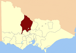
The Electoral district of Dunolly was an electoral district of the Victorian Legislative Assembly. It was created by the Electoral Act Amendment Act 1888, taking effect at the 1889 elections. It was abolished by the Victorian Electoral Districts Boundaries Act 1903 (taking effect at the 1904 elections) when several new districts were created.
The Electoral district of Numurkah and Nathalia was an electoral district of the Victorian Legislative Assembly. It was created by the Electoral Act Amendment Act 1888, taking effect at the 1889 elections. It was abolished by the Victorian Electoral Districts Boundaries Act 1903 (taking effect at the 1904 elections) when several new districts were created.
The Electoral district of Gippsland Central was an electoral district of the Victorian Legislative Assembly. It was created by the Electoral Act Amendment Act 1888, taking effect at the 1889 elections. It was abolished by the Victorian Electoral Districts Boundaries Act 1903 (taking effect at the 1904 elections) when several new districts were created.
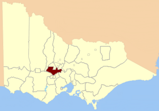
The Electoral district of Clunes and Allandale was an electoral district of the Victorian Legislative Assembly. It was created by the Electoral Act Amendment Act 1888, taking effect at the 1889 elections. It was abolished by the Victorian Electoral Districts Boundaries Act 1903 (taking effect at the 1904 elections) when several new districts were created.
The Electoral district of Donald and Swan Hill was an electoral district of the Victorian Legislative Assembly. It was created by the Electoral Act Amendment Act 1888, taking effect at the 1889 elections. It was abolished by the Victorian Electoral Districts Boundaries Act 1903.
The Electoral district of Kilmore, Dalhousie and Lancefield was an electoral district of the Victorian Legislative Assembly. It was created by the Electoral Act Amendment Act 1888, taking effect at the 1889 elections. The electoral district of Kilmore, Dalhousie and Lancefield replaced Electoral district of Dalhousie.
The Electoral district of Gunbower was an electoral district of the Victorian Legislative Assembly. It was created by The Electoral Act Amendment Act 1888 taking effect at the 1889 elections. The district was bound by the County of Bendigo and the Loddon, Murray and Campaspe Rivers.
The Electoral district of Maryborough and Talbot was an electorate of the Victorian Legislative Assembly from 1877.

The Electoral district of Maryborough was an electorate of the Victorian Legislative Assembly based on an area around Maryborough, Victoria. It was created in the expansion of the Assembly by the Victorian Electoral Act, 1858, which took effect at the election in 1859.

Emerald Hill was an electoral district of the Victorian Legislative Assembly, Australia. It covered part of the inner-city suburb South Melbourne and consisted part of the previous Electoral district of South Melbourne which was abolished in 1859..
Loddon was an electoral district of the Legislative Assembly in the Australian state of Victoria from 1856 to 1859. It was based in northern Victoria around the Loddon River.

Sandhurst was an electoral district of the Legislative Assembly in the Australian state of Victoria from 1856 to 1904. It was based on the towns of Sandhurst (now Bendigo) and Lockwood.
Creswick was an electoral district of the Legislative Assembly in the colony, and later Australian state of Victoria centred on the town of Creswick from 1859 to 1904.
The Electoral district of Sandhurst was an electoral district of the old unicameral Victorian Legislative Council of 1851 to 1856. Victoria being a colony in Australia at the time. Sandhurst was added to the Council in 1855, along with four other districts.

This is a list of members of the Victorian Legislative Assembly from the elections of 26 August – 26 September 1859 to the elections of 2 – 19 August 1861.
This is a list of members of the Victorian Legislative Assembly, from the elections of 28 March 1889 to the elections of 20 April 1892. There were 95 seats in the Assembly from 1889, up from 86 in the previous Parliament.
This is a list of members of the Victorian Legislative Assembly, from the 1902 state election held on 1 October 1902 to the 1904 state election held on 1 June 1904. From 1889 there were 95 seats in the Assembly.
