Related Research Articles

The Bendigo Football Netball League is an Australian rules football and netball competition based in the Bendigo region of Victoria.

The electoral district of Gippsland South is a Lower House electoral district of the Victorian Parliament. It is located within the Eastern Victoria Region of the Legislative Council.

Bendigo East is an electoral district of the Legislative Assembly in the Australian state of Victoria. It covers an area of 2,711 square kilometres (1,047 sq mi) covering the part of the city of Bendigo east of the Yungera railway line and surrounding rural areas to the north, east and south. It includes the Bendigo suburbs of East Bendigo, Epsom, Flora Hill, Junortoun, Kennington, Quarry Hill, Spring Gully, Strathdale, Strathfieldsaye and White Hills, and the surrounding towns of Axedale, Goornong, Huntly, Mandurang, Raywood and Sedgwick. It also includes parts of the localities of Eaglehawk, Elmore, Golden Square and Ravenswood, and the Bendigo campus of La Trobe University. It lies within the Northern Victoria Region of the upper house, the Legislative Council.

Bendigo West is an electoral district of the Legislative Assembly in the Australian state of Victoria. It is a 1,524 square kilometres (588 sq mi) electorate centred on the city of Bendigo west of the Yungera railway line, and including surrounding rural towns to the west and south-west. It encompasses the localities of Bendigo City, California Gully, Castlemaine, Harcourt, Long Gully, Maldon, Marong, Newstead and West Bendigo. It also includes parts of the Bendigo suburbs of Eaglehawk, Golden Square and Kangaroo Flat. It lies within the Northern Victoria Region of the upper house, the Legislative Council.
The Electoral district of Wangaratta was an electoral district of the Victorian Legislative Assembly. It was created in the redistribution of 1904, the Electoral district of Wangaratta and Rutherglen being abolished.
Electoral district of Abbotsford was an electoral district of the Legislative Assembly in the Australian state of Victoria.

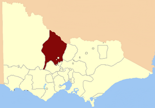
The Electoral district of Mandurang was an electoral district of the Victorian Legislative Assembly (Australia), based in north central Victoria around, but not including, the town of Bendigo.

Members of the Victorian Legislative Council, the upper house of the Parliament of the Australian State of Victoria, are elected from eight multi-member electorates called regions. The Legislative Council has 40 members, five from each of the eight regions.
Walter Alfred Hamilton was an Australian politician. He was a public accountant, auditor and general manager before entering politics.
Northern Province was an electorate of the Victorian Legislative Council (Australia),
Melbourne South Province was an electorate of the Victorian Legislative Council. It was created in June 1904 when Melbourne Province was reduced in size and North Yarra Province and South Yarra Province were abolished. The new Melbourne South, Melbourne North, Melbourne East and Melbourne West Provinces were then created.

Collingwood was an electoral district of the Legislative Assembly in the Australian state of Victoria from 1856 to 1958. It centred on the Melbourne suburb of Collingwood, Victoria.

West Melbourne was an electoral district of the Legislative Assembly in the Australian state of Victoria from 1859 to 1904.
Loddon was an electoral district of the Legislative Assembly in the Australian state of Victoria from 1856 to 1859. It was based in northern Victoria around the Loddon River.

Sandhurst was an electoral district of the Legislative Assembly in the Australian state of Victoria from 1856 to 1904. It was based on the towns of Sandhurst (now Bendigo) and Lockwood.

Castlemaine was an electoral district of the Legislative Assembly in the Australian state of Victoria from 1859 to 1904. It included the towns of Castlemaine, Muckleford and Harcourt.
Jolimont and West Richmond was an electoral district of the Legislative Assembly in the Australian state of Victoria from 1889 to 1904. It was located in the inner eastern suburbs of Melbourne and included parts of Richmond and Jolimont.

The Hume is an economic rural region located in the north-eastern part of Victoria, Australia. Comprising an area in excess of 40,000 square kilometres (15,000 sq mi) with a population that ranges from 263,000 to 300,000, the Hume region includes the local government areas of Alpine Shire, Rural City of Benalla, City of Wodonga, City of Greater Shepparton, Shire of Indigo, Shire of Mansfield, Shire of Strathbogie, Shire of Towong and the Rural City of Wangaratta, and also includes five unincorporated areas encompassing the alpine ski resorts in the region.
This is a list of members of the Victorian Legislative Assembly, from the 1902 state election held on 1 October 1902 to the 1904 state election held on 1 June 1904. From 1889 there were 95 seats in the Assembly.
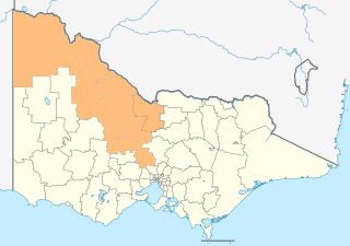
The Loddon Mallee is an economic rural region located in the north-western part of Victoria, Australia. Occupying more than a quarter of the state it stretches from Greater Melbourne to the Northern most point of Victoria, sharing a border with South Australia and New South Wales and has one of the most consistently warm climates in Victoria. It has two major regional cities Bendigo and Mildura and also contains the major settlements of Castlemaine, Echuca, Gisborne, Kerang, Kyneton, Maryborough, Swan Hill, Wedderburn and Wycheproof.
References
- 1 2 3 "Re-Member (Former Members)". State Government of Victoria. Retrieved 6 May 2013.
- ↑ "The Electoral Districts Alteration Bill". The Argus. Trove. 5 November 1888. Retrieved 6 May 2013.