Geelong is a port city in the southeastern Australian state of Victoria, located at the eastern end of Corio Bay and the left bank of Barwon River, about 65 km (40 mi) southwest of Melbourne, the state capital of Victoria.

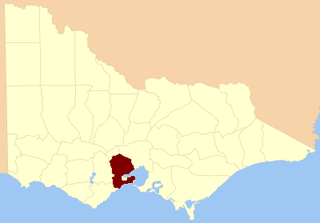
The City of Greater Geelong is a local government area in the Barwon South West region of Victoria, Australia, located in the western part of the state. It covers an area of 1,248 square kilometres (482 sq mi) and, had a population of 271,057 as of the 2021 Australian census. It is primarily urban with the vast majority of its population living in the Greater Geelong urban area, while other significant settlements within the LGA include Anakie, Balliang, Barwon Heads, Batesford, Ceres, Clifton Springs, Drysdale, Lara, Ocean Grove, Portarlington and St Leonards. It was formed in 1993 from the amalgamation of the Rural City of Bellarine, Shire of Corio, City of Geelong, City of Geelong West, City of Newtown, City of South Barwon, and parts of Shire of Barrabool and Shire of Bannockburn.
The Division of Corio is an Australian electoral division in the state of Victoria. The division was proclaimed in 1900, and was one of the original 65 divisions to be contested at the first federal election. Named for Corio Bay, it has always been based on the city of Geelong, although in the past it stretched as far east as the outer western suburbs of Melbourne.

The City of Geelong was a local government area about 75 kilometres (47 mi) southwest of Melbourne, the state capital of Victoria, Australia. The city covered an area of 13.4 square kilometres (5.2 sq mi), and existed from 1849 until 1993.

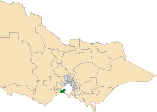
The electoral district of Geelong is an electoral district of the Victorian Legislative Assembly. It centres on inner metropolitan Geelong and following the June 2013 redistribution of electoral boundaries includes the suburbs of Belmont, Breakwater, East Geelong, Geelong, Geelong West, Newtown and South Geelong, Herne Hill, Manifold Heights, Newcomb, Newtown, St Albans Park, Thomson, Whittington and part of Fyansford.
The City of Geelong West was a local government area about 5 kilometres (3 mi) west of the regional city of Geelong, Victoria, Australia. The city covered an area of 5.26 square kilometres (2.0 sq mi), and existed from 1875 until 1993.
The City of Newtown was a local government area about 3 kilometres (1.9 mi) west of the regional city of Geelong, Victoria, Australia. The city covered an area of 6.22 square kilometres (2.4 sq mi), and existed from 1858 until 1993.

The Shire of Corio was a local government area located between Geelong and Werribee, about 60 kilometres (37 mi) southwest of Melbourne, the state capital of Victoria, Australia. The shire, which included all of Geelong's northern suburbs, covered an area of 704.66 square kilometres (272.1 sq mi), and existed from 1861 until 1993.
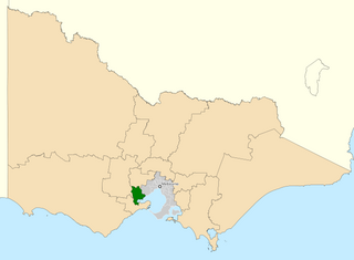
The electoral district of Bellarine is one of the electoral districts of Victoria, Australia, for the Victorian Legislative Assembly. It covers an area of 367 square kilometres (142 sq mi) stretching from the Bellarine Peninsula to the outer eastern suburbs of Geelong. It includes the towns of Barwon Heads, Clifton Springs, Drysdale, Indented Head, Ocean Grove, Point Lonsdale, Portarlington and Queenscliff and the Geelong suburbs of Leopold and Moolap. It lies within the Western Victoria Region of the upper house, the Legislative Council.

The electoral district of Wimmera was an electoral district of the Legislative Assembly in the Australian state of Victoria.

Ararat was an electoral district of the Legislative Assembly in the Australian state of Victoria. The electorate was abolished in 1904 and replaced by the electoral district of Stawell and Ararat.

Polwarth, Ripon, Hampden and South Grenville was an electoral district of the Legislative Assembly in the Australian state of Victoria from 1856 to 1859. It was based in western Victoria.
South Grant was an electoral district of the Legislative Assembly in the Australian state of Victoria from 1856 to 1877.

Castlemaine was an electoral district of the Legislative Assembly in the Australian state of Victoria from 1859 to 1904. It included the towns of Castlemaine, Muckleford and Harcourt.

Geelong East was an electoral district of the Legislative Assembly in the Australian state of Victoria from 1859 to 1985. It was located south of the city of Geelong, defined in the Victorian Electoral Act, 1858 as:
Commencing at the north-western angle of the town reserve of Geelong; thence by a line south to the River Barwon; thence westward and northwestward by the River Barwon to the western boundary of the reserve at the junction of the Moorabool and Barwon; thence east by the northern boundary of section 25, parish of Barrabool; thence south by the eastern boundaries of sections 25 and 11, and by part of the eastern boundary of section 7, all in the same parish; thence south-easterly by a curved line crossing the Waurn Chain of Ponds to the southern boundary of section 3, parish of Conewarre; thence east by the southern boundaries of sections 3 and 4 in the same parish; thence north-easterly by a curved line crossing the River Barwon to the south-eastern angle of section 11 in the parish of Moolap; thence by the eastern boundary of that section and a line north to the shores of Corio Bay; and thence by the shores of Corio Bay to the north-western angle of the town reserve, the commencing point aforesaid, including the remaining portion of the reserve at Point Henry.

Gippsland North was an electoral district of the Legislative Assembly in the Australian state of Victoria located in northern Gippsland from 1859 to 1955.
The Electoral district of Geelong was one of the original sixteen electoral districts of the old unicameral Victorian Legislative Council of 1851 to 1856. Victoria being a colony in Australia at the time.

This is a list of members of the Victorian Legislative Assembly from the elections of 26 August – 26 September 1859 to the elections of 2 – 19 August 1861.
This is a list of members of the Victorian Legislative Assembly, from the elections of 11 May 1877. Victoria was a British self-governing colony in Australia at the time.
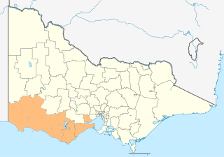
The Barwon South West is an economic rural region located in the southwestern part of Victoria, Australia. The Barwon South West region stretches from the tip of the Queenscliff Heads to the border of South Australia. It is home to Victoria’s largest provincial centre, Geelong and the major centres of Aireys Inlet, Apollo Bay, Camperdown, Colac, Hamilton, Lorne, Port Campbell, Port Fairy, Portland, Torquay and Warrnambool. It draws its name from the Barwon River and the geographic location of the region in the state of Victoria.
