The Electoral district of Clunes and Allandale was an electoral district of the Victorian Legislative Assembly. It was created by the Electoral Act Amendment Act 1888, taking effect at the 1889 elections. It was abolished by the Victorian Electoral Districts Boundaries Act 1903 (taking effect at the 1904 elections) when several new districts were created.
The Electoral district of Donald and Swan Hill was an electoral district of the Victorian Legislative Assembly. It was created by the Electoral Act Amendment Act 1888, taking effect at the 1889 elections. It was abolished by the Victorian Electoral Districts Boundaries Act 1903.
The Electoral district of Kilmore, Dalhousie and Lancefield was an electoral district of the Victorian Legislative Assembly. It was created by the Electoral Act Amendment Act 1888, taking effect at the 1889 elections. The electoral district of Kilmore, Dalhousie and Lancefield replaced Electoral district of Dalhousie.

The Electoral district of Maldon was an electoral district of the Victorian Legislative Assembly.
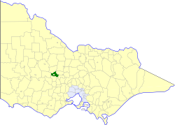
The Shire of Tullaroop was a local government area about 170 kilometres (106 mi) northwest of Melbourne, the state capital of Victoria, Australia, surrounding the regional centre of Maryborough. The shire covered an area of 637.63 square kilometres (246.2 sq mi), and existed from 1861 until 1995. Maryborough itself was managed by a separate entity, ultimately known as the City of Maryborough. After a large-scale statewide amalgamation program by the Victorian Government in 1994, they were united under the Shire of Central Goldfields.

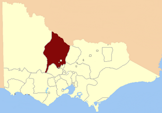
The Shire of Bet Bet was a local government area located about 180 kilometres (112 mi) northwest of Melbourne, the state capital of Victoria, Australia. The shire covered an area of 928.2 square kilometres (358.4 sq mi), and existed from 1861 until 1995.

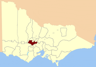
The City of Maryborough was a local government area about 170 kilometres (106 mi) northwest of Melbourne, the state capital of Victoria, Australia, and the governing body for the regional centre of Maryborough. The City covered an area of 23.32 square kilometres (9.0 sq mi), and existed from 1857 until 1995. The City of Maryborough was surrounded by the Shire of Tullaroop, which was united with Maryborough under the Shire of Central Goldfields as part of a large-scale statewide amalgamation program by the Victorian Government in 1994-95.

Timor (/ˈtaɪˈmɔː/), also known as Timor-Bowenvale, is a mainly rural area in the Central Goldfields Shire of Victoria, Australia. It is located 8 kilometres (5 mi) north of Maryborough, Victoria and 178 kilometres (111 mi) northwest of Melbourne, the state capital.
The Electoral district of Maryborough and Talbot was an electorate of the Victorian Legislative Assembly from 1877.
The Electoral district of Korong was an electoral district of the Legislative Assembly in the Australian state of Victoria.
Wellington Province was an electorate of the Victorian Legislative Council, the upper house of the Victorian Parliament.
Nelson Province was an electorate of the Victorian Legislative Council (Australia). It was created in the wide-scale redistribution of Provinces 1882 when Central and Eastern Provinces were abolished and ten new Provinces were created. Its area included Camperdown, Ararat and Mortlake.

Collingwood was an electoral district of the Legislative Assembly in the Australian state of Victoria from 1856 to 1958. It centred on the Melbourne suburb of Collingwood, Victoria.
Loddon was an electoral district of the Legislative Assembly in the Australian state of Victoria from 1856 to 1859. It was based in northern Victoria around the Loddon River.

Talbot was an electoral district of the Legislative Assembly in the Australian colony of Victoria from 1856 to 1859. It was based in western Victoria, bounded on the west by Bet Bet Creek, the north by the Loddon River, on the east by the Coliban River and included the area around the towns of Creswick, Daylesford and Carisbrook.

Avoca was an electoral district of the Legislative Assembly in the Australian state of Victoria from 1859 to 1889. It was based in northern Victoria. It was defined by the 1858 Electoral Act as:
Commencing at the source of the River Avoca in the Main Dividing Range ; thence northwards by that river and by a line bearing north to the River Murray ; thence by the River Murray to the River Loddon; thence south-wards by the River Loddon to McNeil's Creek; thence by McNeil's Creek to the Main Dividing Range; and thence westerly by the Main Dividing Range to the commencing point aforesaid, including the parish of Tarnagulla.
Creswick was an electoral district of the Legislative Assembly in the colony, and later Australian state of Victoria centred on the town of Creswick from 1859 to 1904.

Grenville was an electoral district of the Legislative Assembly in the Australian state of Victoria from 1859 to 1927. It was located in western Victoria, south of Ballarat.

This is a list of members of the Victorian Legislative Assembly from the elections of 26 August – 26 September 1859 to the elections of 2 – 19 August 1861.
This is a list of members of the Victorian Legislative Assembly, from the elections of 11 May 1877. Victoria was a British self-governing colony in Australia at the time.
