The electoral district of Benambra is one of the electoral districts of Victoria, Australia, for the Victorian Legislative Assembly. It covers an area of 10,037 square kilometres (3,875 sq mi) in north-eastern Victoria. The largest settlement is the city of Wodonga. Benambra also includes the towns towns of Baranduda, Barnawartha, Beechworth, Chiltern, Corryong, Eskdale, Kiewa, Mitta Mitta, Mount Beauty, Rutherglen, Tallangatta, Tangambalanga, Tawonga, Wahgunyah, and Yackandandah. It lies in the Northern Victoria Region of the upper house, the Legislative Council.
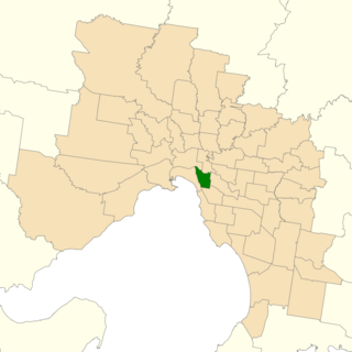
Prahran is an electoral district of the Legislative Assembly in the Australian state of Victoria. It was created by the Electoral Act Amendment Act 1888, taking effect at the 1889 elections. It is the state's smallest electorate of 12 km² in the inner south-east of Melbourne, taking in the suburbs of South Yarra, Prahran and Windsor, as well as parts of Balaclava, St Kilda, St Kilda East and Toorak. The electorate had a population of 54,141 at the 2001 census.

The electoral district of Melbourne is an electorate of the Victorian Legislative Assembly. It currently includes the localities of Carlton, North Carlton, Melbourne, East Melbourne, West Melbourne, North Melbourne, Parkville, Newmarket, Kensington and Flemington, and includes Melbourne University. The district has been in existence since 1856.

The electoral district of Lowan is a rural Victorian Legislative Assembly electoral district of the Victorian Parliament. It is located within the Western Victoria Region of the Legislative Council. It was initially created by the Electoral Act Amendment Act 1888, taking effect at the 1889 elections.

The electoral district of Footscray is an electoral district of the Victorian Legislative Assembly. It lies just north of Melbourne and covers the suburbs of Footscray, Maribyrnong and Seddon.
Port Melbourne was an electoral district of the Victorian Legislative Assembly. It was created in 1889, replacing the previous electorate of Sandridge, which was the former name for Port Melbourne.
Electoral district of Eaglehawk was an electoral district of the Legislative Assembly in the Australian state of Victoria. It was created by the Electoral Act Amendment Act 1888, taking effect at the 1889 elections. It was abolished by the Electoral Districts Act 1926 (taking effect at the 1927 elections) when several new districts were created.
The Electoral district of Dunolly was an electoral district of the Victorian Legislative Assembly. It was created by the Electoral Act Amendment Act 1888, taking effect at the 1889 elections. It was abolished by the Victorian Electoral Districts Boundaries Act 1903 (taking effect at the 1904 elections) when several new districts were created.
The Electoral district of Numurkah and Nathalia was an electoral district of the Victorian Legislative Assembly. It was created by the Electoral Act Amendment Act 1888, taking effect at the 1889 elections. It was abolished by the Victorian Electoral Districts Boundaries Act 1903 (taking effect at the 1904 elections) when several new districts were created.
The Electoral district of Gippsland Central was an electoral district of the Victorian Legislative Assembly. It was created by the Electoral Act Amendment Act 1888, taking effect at the 1889 elections. It was abolished by the Victorian Electoral Districts Boundaries Act 1903 (taking effect at the 1904 elections) when several new districts were created.
The Electoral district of Clunes and Allandale was an electoral district of the Victorian Legislative Assembly. It was created by the Electoral Act Amendment Act 1888, taking effect at the 1889 elections. It was abolished by the Victorian Electoral Districts Boundaries Act 1903 (taking effect at the 1904 elections) when several new districts were created.
The Electoral district of Kilmore, Dalhousie and Lancefield was an electoral district of the Victorian Legislative Assembly. It was created by the Electoral Act Amendment Act 1888, taking effect at the 1889 elections. The electoral district of Kilmore, Dalhousie and Lancefield replaced Electoral district of Dalhousie.
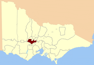
The Electoral district of Gunbower was an electoral district of the Victorian Legislative Assembly. It was created by The Electoral Act Amendment Act 1888 taking effect at the 1889 elections. The district was bound by the County of Bendigo and the Loddon, Murray and Campaspe Rivers.
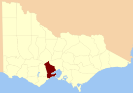
The Electoral district of Maryborough and Talbot was an electorate of the Victorian Legislative Assembly from 1877.

The Electoral district of Maryborough was an electorate of the Victorian Legislative Assembly based on an area around Maryborough, Victoria. It was created in the expansion of the Assembly by the Victorian Electoral Act, 1858, which took effect at the election in 1859.

Ararat was an electoral district of the Legislative Assembly in the Australian state of Victoria. The electorate was abolished in 1904 and replaced by the electoral district of Stawell and Ararat.

Emerald Hill was an electoral district of the Victorian Legislative Assembly, Australia. It covered part of the inner-city suburb South Melbourne and consisted part of the previous Electoral district of South Melbourne which was abolished in 1859..
Carlton was an electoral district of the Legislative Assembly in the Australian state of Victoria located in the inner-Melbourne suburb of Carlton from 1877 to 1958.
Creswick was an electoral district of the Legislative Assembly in the colony, and later Australian state of Victoria centred on the town of Creswick from 1859 to 1904.
This is a list of members of the Victorian Legislative Assembly, from the elections of 11 May 1877. Victoria was a British self-governing colony in Australia at the time.