The electoral district of Melbourne is an electorate of the Victorian Legislative Assembly. It currently includes the localities of Docklands, Carlton, Melbourne, East Melbourne, West Melbourne, North Melbourne, Parkville, Newmarket, Kensington and Flemington, and includes Melbourne University. The district has been in existence since 1856.
The Electoral district of Donald and Swan Hill was an electoral district of the Victorian Legislative Assembly. It was created by the Electoral Act Amendment Act 1888, taking effect at the 1889 elections. It was abolished by the Victorian Electoral Districts Boundaries Act 1903.
The Electoral district of Wangaratta was an electoral district of the Victorian Legislative Assembly. It was created in the redistribution of 1904, the Electoral district of Wangaratta and Rutherglen being abolished.
Melbourne West Province was an electorate of the Victorian Legislative Council from 1904 until 2006.

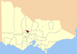
The Electoral district of Mandurang was an electoral district of the Victorian Legislative Assembly (Australia), based in north central Victoria around, but not including, the town of Bendigo.
The Electoral district of Maryborough and Talbot was an electorate of the Victorian Legislative Assembly from 1877.

The Electoral district of Maryborough was an electorate of the Victorian Legislative Assembly based on an area around Maryborough, Victoria. It was created in the expansion of the Assembly by the Victorian Electoral Act, 1858, which took effect at the election in 1859.

Emerald Hill was an electoral district of the Victorian Legislative Assembly, Australia. It covered part of the inner-city suburb South Melbourne and consisted part of the previous Electoral district of South Melbourne which was abolished in 1859..
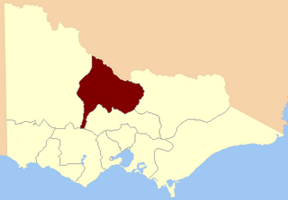
The Electoral district of Korong was an electoral district of the Legislative Assembly in the Australian state of Victoria.

Collingwood was an electoral district of the Legislative Assembly in the Australian state of Victoria from 1856 to 1958. It centred on the Melbourne suburb of Collingwood, Victoria.

West Bourke was an electoral district of the Legislative Assembly in the Australian state of Victoria from 1856 to 1904.

East Bourke Boroughs was an electoral district of the Legislative Assembly in the Australian state of Victoria from 1859 to 1904.
Loddon was an electoral district of the Legislative Assembly in the Australian state of Victoria from 1856 to 1859. It was based in northern Victoria around the Loddon River.

Ovens was an electoral district of the Legislative Assembly in the Australian state of Victoria from 1856 to 1927. It was based in northern Victoria, bordered by the Ovens River in the south-west and included the town of Beechworth, Victoria.

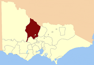
Avoca was an electoral district of the Legislative Assembly in the Australian state of Victoria from 1859 to 1889. It was based in northern Victoria. It was defined by the 1858 Electoral Act as:
Commencing at the source of the River Avoca in the Main Dividing Range ; thence northwards by that river and by a line bearing north to the River Murray ; thence by the River Murray to the River Loddon; thence south-wards by the River Loddon to McNeil's Creek; thence by McNeil's Creek to the Main Dividing Range; and thence westerly by the Main Dividing Range to the commencing point aforesaid, including the parish of Tarnagulla.
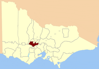
Creswick was an electoral district of the Legislative Assembly in the colony, and later Australian state of Victoria centred on the town of Creswick from 1859 to 1904.

Geelong East was an electoral district of the Legislative Assembly in the Australian state of Victoria from 1859 to 1985. It was located south of the city of Geelong, defined in the Victorian Electoral Act, 1858 as:
Commencing at the north-western angle of the town reserve of Geelong; thence by a line south to the River Barwon; thence westward and northwestward by the River Barwon to the western boundary of the reserve at the junction of the Moorabool and Barwon; thence east by the northern boundary of section 25, parish of Barrabool; thence south by the eastern boundaries of sections 25 and 11, and by part of the eastern boundary of section 7, all in the same parish; thence south-easterly by a curved line crossing the Waurn Chain of Ponds to the southern boundary of section 3, parish of Conewarre; thence east by the southern boundaries of sections 3 and 4 in the same parish; thence north-easterly by a curved line crossing the River Barwon to the south-eastern angle of section 11 in the parish of Moolap; thence by the eastern boundary of that section and a line north to the shores of Corio Bay; and thence by the shores of Corio Bay to the north-western angle of the town reserve, the commencing point aforesaid, including the remaining portion of the reserve at Point Henry.
Jolimont and West Richmond was an electoral district of the Legislative Assembly in the Australian state of Victoria from 1889 to 1904. It was located in the inner eastern suburbs of Melbourne and included parts of Richmond and Jolimont.
The Electoral district of Geelong was one of the original sixteen electoral districts of the old unicameral Victorian Legislative Council of 1851 to 1856. Victoria being a colony in Australia at the time.
The Electoral district of Loddon was one of the original sixteen electoral districts of the old unicameral Victorian Legislative Council of 1851 to 1856. Victoria being a colony in Australia at the time.