Related Research Articles

The electoral district of Geelong is an electoral district of the Victorian Legislative Assembly. It centres on inner metropolitan Geelong and following the June 2013 redistribution of electoral boundaries includes the suburbs of Belmont, Breakwater, East Geelong, Geelong, Geelong West, Newtown and South Geelong, Herne Hill, Manifold Heights, Newcomb, Newtown, St Albans Park, Thomson, Whittington and part of Fyansford.

The Electoral district of Colac was an electoral district of the Victorian Legislative Assembly, one of the inaugural districts of the first Assembly in 1856.

The Electoral district of Maldon was an electoral district of the Victorian Legislative Assembly.
The Electoral district of Castlemaine and Maldon was an electoral district of the Victorian Legislative Assembly (Australia).

The Electoral district of Evelyn and Mornington was an electoral district of the Victorian Legislative Assembly.
The Electoral district of Daylesford was an electoral district of the Victorian Legislative Assembly. It included the town of Daylesford, around 155 km north-west of Melbourne.
The Electoral district of Midlands was an electoral district of the Victorian Legislative Assembly.

The electoral district of Warrenheip was an electorate of the Victorian Legislative Assembly in the British colony, and later Australian state, of Victoria. Created in 1889, the electorate was abolished in 1927 when it became the electoral district of Warrenheip and Grenville.
Geelong Province was an electorate of the Victorian Legislative Council until 2006, located around Geelong. It was abolished from the 2006 state election in the wake of the Bracks Labor government's reform of the Legislative Council. The area of the former Geelong Province then became part of the larger Western Victoria Region.

The Electoral district of Portland was an electorate of the Victorian Legislative Council (Australia).
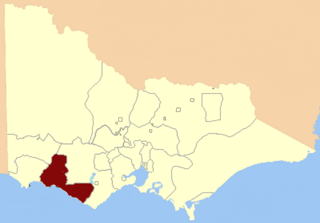
Villiers and Heytesbury was an electoral district of the Legislative Assembly in the Australian state of Victoria from 1856 to 1904. It was based in western Victoria, and included the area from Lake Corangamite along the coast westward past Port Fairy.

East Bourke was an electoral district of the Legislative Assembly in the Australian state of Victoria from 1856 to 1904.

Polwarth, Ripon, Hampden and South Grenville was an electoral district of the Legislative Assembly in the Australian state of Victoria from 1856 to 1859. It was based in western Victoria.
South Grant was an electoral district of the Legislative Assembly in the Australian state of Victoria from 1856 to 1877.
The Electoral district of Castlemaine and Kyneton was an electoral district of the Victorian Legislative Assembly (Australia).

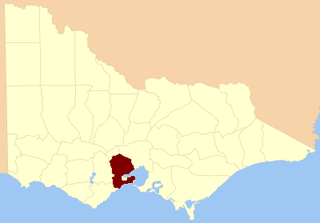
Geelong East was an electoral district of the Legislative Assembly in the Australian state of Victoria from 1859 to 1985. It was located south of the city of Geelong, defined in the Victorian Electoral Act, 1858 as:
Commencing at the north-western angle of the town reserve of Geelong; thence by a line south to the River Barwon; thence westward and northwestward by the River Barwon to the western boundary of the reserve at the junction of the Moorabool and Barwon; thence east by the northern boundary of section 25, parish of Barrabool; thence south by the eastern boundaries of sections 25 and 11, and by part of the eastern boundary of section 7, all in the same parish; thence south-easterly by a curved line crossing the Waurn Chain of Ponds to the southern boundary of section 3, parish of Conewarre; thence east by the southern boundaries of sections 3 and 4 in the same parish; thence north-easterly by a curved line crossing the River Barwon to the south-eastern angle of section 11 in the parish of Moolap; thence by the eastern boundary of that section and a line north to the shores of Corio Bay; and thence by the shores of Corio Bay to the north-western angle of the town reserve, the commencing point aforesaid, including the remaining portion of the reserve at Point Henry.
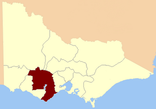
Geelong West was an electoral district of the Legislative Assembly in the Australian state of Victoria from 1859 to 1985. It was located west of the city of Geelong, defined in the Victorian Electoral Act, 1858 as:
Bounded on the north and north-west by a line drawn at a distance of 2 miles from the north-western angle of the town reserve of Geelong, as a centre from the western shore of Corio Bay, near Cowie's Creek, to a road leading to the River Barwon; on the west by that road; on the south-west and south by the River Barwon; and on the east by the western boundary of the town reserve of Geelong and the shores of Corio Bay, including the reserve at the junction of the Barwon and Moorabool
The Electoral district of Geelong was one of the original sixteen electoral districts of the old unicameral Victorian Legislative Council of 1851 to 1856. Victoria being a colony in Australia at the time.
The Electoral district of Ripon, Hampden, Grenville and Polwarth was one of the original sixteen electoral districts of the old unicameral Victorian Legislative Council of 1851 to 1856. Victoria being a colony in Australia at the time.

The Electoral district of Villiers and Heytesbury was one of the original sixteen electoral districts of the old unicameral Victorian Legislative Council of 1851 to 1856. Victoria being a colony in Australia at the time.
References
- ↑ "Re-Member (Former Members)". State Government of Victoria. Retrieved 27 April 2013.
Coordinates: 38°08′S144°20′E / 38.133°S 144.333°E
| | This Victoria (Australia) government-related article is a stub. You can help Wikipedia by expanding it. |