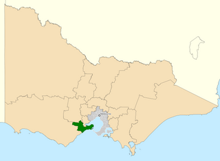
The Division of Corangamite is an Australian electoral division in the state of Victoria. The division was proclaimed in 1900, and was one of the original 65 divisions to be contested at the first federal election. It is named for Lake Corangamite, although the lake no longer falls within the division's boundaries.

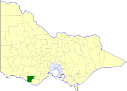
The Division of Ballarat is an Australian electoral division in the state of Victoria. The division was proclaimed in 1900, and was one of the original 65 divisions to be contested at the first federal election. It was named for the provincial city of the same name by Scottish squatter Archibald Yuille, who established the first settlement − his sheep run called Ballaarat − in 1837, with the name derived from a local Wathawurrung word for the area, balla arat, thought to mean "resting place".

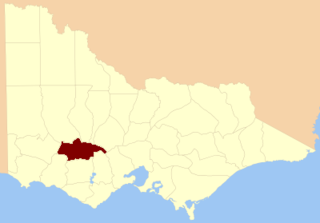
The Shire of Hampden was a local government area about 200 kilometres (124 mi) west-southwest of Melbourne, the state capital of Victoria, Australia. The shire covered an area of 2,620.91 square kilometres (1,011.9 sq mi), and existed from 1857 until 1994.
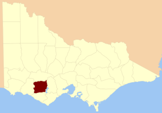
The Shire of Heytesbury was a local government area about 200 kilometres (124 mi) west-southwest of Melbourne, the state capital of Victoria, Australia. The shire covered an area of 1,558.39 square kilometres (601.7 sq mi), and existed from 1895 until 1994.
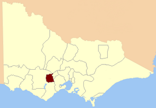
The County of Ripon is one of the 37 counties of Victoria which are part of the cadastral divisions of Australia, used for land titles. The county includes the plains of the Western District from Ballarat in the east to the Grampians in the west. Larger towns include Beaufort. The county was proclaimed in 1849.
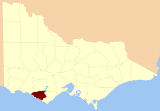
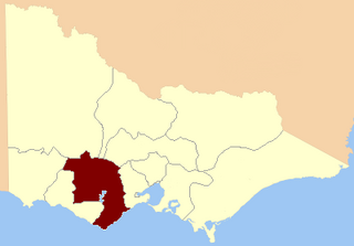
The County of Hampden is one of the 37 counties of Victoria which are part of the cadastral divisions of Australia, used for land titles. The county is in the Western District of Victoria bounded by Lake Corangamite in the east and the Hopkins River in the west. In the north and south the county was bounded approximately by the existing roads, now the Glenelg Highway and the Princes Highway. Larger towns include Terang and Skipton. The county was proclaimed in 1849.
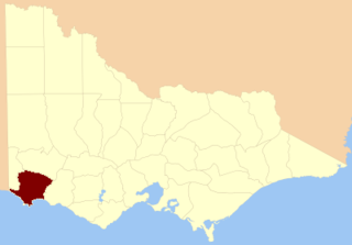
The County of Heytesbury is one of the 37 counties of Victoria which are part of the cadastral divisions of Australia, used for land titles. The county is in the Western District of Victoria bounded by the Gellibrand River in the east and the Hopkins River in the west. In the north, the county was bounded approximately by the existing road, now the Princes Highway. Larger towns include Camperdown and Cobden. The county was proclaimed in 1849.

The County of Dundas is one of the 37 counties of Victoria which are part of the cadastral divisions of Australia, used for land titles. The county is in the Western District of Victoria bounded by the Glenelg River in the west and north, by a line from Casterton to Penshurst in the south, and by the eastern edge of the Grampians in the east. Larger towns include Hamilton, Casterton and Coleraine. The county was proclaimed in 1849.
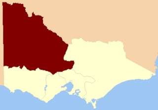
The County of Normanby in Victoria, is one of the 37 counties of Victoria which are part of the cadastral divisions of Australia, used for land titles. The county is in the Western District of Victoria bounded by the Glenelg River in the west and the Eumeralla River in the east, by a line through Casterton and Hamilton in the north, and by Bass Strait to the south. Larger towns include Hamilton, Portland and Heywood. The county was proclaimed in 1853, but it was known earlier since the 1849 proclamation of Follett County and Dundas County referred to its boundaries.
The Electoral district of Normanby was an electoral district in the Legislative Assembly of Victoria, it covered an area from the South Australian border to Portland Bay.

Western Province was an electorate of the Victorian Legislative Council (Australia), the upper house of the Parliament of Victoria. Victoria was a colony in Australia when Western Province was created. From Federation in 1901, Victoria was a state in the Commonwealth of Australia.
North Western Province was an electorate of the Victorian Legislative Council (Australia), created in 1856 and was abolished in 2006.
Nelson Province was an electorate of the Victorian Legislative Council (Australia). It was created in the wide-scale redistribution of Provinces 1882 when Central and Eastern Provinces were abolished and ten new Provinces were created. Its area included Camperdown, Ararat and Mortlake.
North Grenville was an electoral district of the Legislative Assembly in the Australian state of Victoria from 1856 to 1859. It was bordered on the east by the Yarrowee River and included an area south of Ballarat. The short-lived, rural district of North Grenville was one of the initial districts of the first Victorian Legislative Assembly, 1856.

Polwarth, Ripon, Hampden and South Grenville was an electoral district of the Legislative Assembly in the Australian state of Victoria from 1856 to 1859. It was based in western Victoria.

Grenville was an electoral district of the Legislative Assembly in the Australian state of Victoria from 1859 to 1927. It was located in western Victoria, south of Ballarat.

Polwarth and South Grenville was an electoral district of the Legislative Assembly in the Australian state of Victoria from 1859 to 1889. It was based in western Victoria.

Ripon and Hampden was an electoral district of the Legislative Assembly in the Australian state of Victoria from 1859 to 1904. It was based in western Victoria.
Mentone was an electoral district of the Legislative Assembly in the Australian state of Victoria from 1945 to 1992. It centred on the south-eastern Melbourne suburb of Mentone.
The Electoral district of Ripon, Hampden, Grenville and Polwarth was one of the original sixteen electoral districts of the old unicameral Victorian Legislative Council of 1851 to 1856. Victoria being a colony in Australia at the time.
