Related Research Articles

The City of Moonee Valley is a local government area located within the metropolitan area of Melbourne, Victoria, Australia. It comprises the north-western suburbs between 3 and 13 kilometres from the Melbourne city centre, and in June 2018, the city had a population of 127,883.

The Division of Melbourne is an Australian electoral division in the State of Victoria, represented since the 2010 election by Adam Bandt, leader of the Australian Greens.

The Moonee Ponds Creek is a creek and major tributary of the Yarra River running through urban Melbourne, Victoria, Australia from northern to inner suburbs. In 2004 a reporter for the Age newspaper described it as "arguably the most abused tributary of the Yarra River, and part of the true underside of Melbourne".

The Division of Maribyrnong is an Australian electoral division in the state of Victoria. It is located in the inner north-western suburbs of Melbourne. It covers the suburbs of Aberfeldie, Airport West, Avondale Heights, Braybrook, Essendon, Gowanbrae, Kealba, Keilor East, Maribyrnong, Moonee Ponds, Niddrie, St Albans and Sunshine North. Due to redistributions, the division has been slowly moving west. It originally included the suburbs of Footscray and North Melbourne. According to the 2011 census, Maribyrnong has the highest proportion of Catholics in any Commonwealth Electoral Division in Australia with 41.6% of the population.
Richmond is an electoral district of the Legislative Assembly in the Australian state of Victoria. It is currently a 14 km² electorate in the inner east of Melbourne, encompassing the suburbs of Richmond, Cremorne, Burnley, Abbotsford, Collingwood, Clifton Hill, North Fitzroy and Fitzroy. Historically a very safe seat for the Labor Party, Richmond has in recent elections become increasingly marginal against the Greens, who narrowly failed to win it at the 2014 Victorian State election.

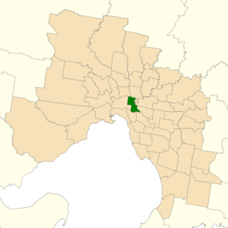
The electoral district of Essendon is an electoral district of the Victorian Legislative Assembly. It was first created in 1904 after the abolition of the larger Essendon and Flemington electorate, and covers some of the north-western suburbs of Melbourne, including Essendon, Moonee Ponds and Ascot Vale.
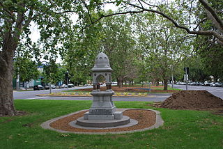
Mount Alexander Road is a major road in Melbourne's inner northern suburbs.
Essendon and Flemington was an electoral district of the Victorian Legislative Assembly from 1889 to 1904. It was held for most of its existence by future Prime Minister Alfred Deakin before his switch to federal politics in 1901. It was abolished in 1904 and replaced with separate Essendon and Flemington electorates.

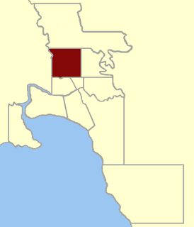
The City of Essendon was a local government area about 5 kilometres (3 mi) northwest of Melbourne, the state capital of Victoria, Australia. The city covered an area of 21.22 square kilometres (8.19 sq mi), and existed from 1861 until 1994.
Port Melbourne was an electoral district of the Victorian Legislative Assembly. It was created in 1889, replacing the previous electorate of Sandridge, which was the former name for Port Melbourne.
Electoral district of Moonee Ponds was an electoral district of the Legislative Assembly in the Australian state of Victoria.
Melbourne West Province was an electorate of the Victorian Legislative Council from 1904 until 2006.
The Electoral district of Castlemaine and Maldon was an electoral district of the Victorian Legislative Assembly (Australia).
The Electoral district of Midlands was an electoral district of the Victorian Legislative Assembly.

Bulla and Dalhousie was an electoral district of the Victorian Legislative Assembly. It was created in 1927 with the merging of the previous districts of Bulla and Dalhousie, and was abolished in 1945, with most of the territory going into the new Mernda seat. It was a rural electorate on the outskirts of Melbourne, and at its abolition included Broadmeadows, Gisborne, Lancefield and Sunbury.

West Bourke was an electoral district of the Legislative Assembly in the Australian state of Victoria from 1856 to 1904.
The Electoral district of Castlemaine and Kyneton was an electoral district of the Victorian Legislative Assembly (Australia).
North Melbourne was an electoral district of the Legislative Assembly in the Australian state of Victoria from 1859 to 1927.
This is a list of members of the Victorian Legislative Assembly, from the elections of 28 March 1889 to the elections of 20 April 1892. There were 95 seats in the Assembly from 1889, up from 86 in the previous Parliament.
This is a list of members of the Victorian Legislative Assembly, from the 1902 state election held on 1 October 1902 to the 1904 state election held on 1 June 1904. From 1889 there were 95 seats in the Assembly.
References
- 1 2 "Re-Member (Former Members)". State Government of Victoria. Retrieved 24 May 2014.
Coordinates: 37°47′05″S144°55′40″E / 37.78472°S 144.92778°E