Geelong is a port city in Victoria, Australia, located at the eastern end of Corio Bay and the left bank of Barwon River, about 65 km (40 mi) southwest of Melbourne.

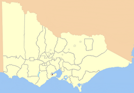
The City of Greater Geelong is a local government area in the Barwon South West region of Victoria, Australia, located in the western part of the state. It covers an area of 1,248 square kilometres (482 sq mi) and, had a population of 271,057 as of the 2021 Australian census. It is primarily urban with the vast majority of its population living in the Greater Geelong urban area, while other significant settlements within the LGA include Anakie, Balliang, Barwon Heads, Batesford, Ceres, Clifton Springs, Drysdale, Lara, Ocean Grove, Portarlington and St Leonards. It was formed in 1993 from the amalgamation of the Rural City of Bellarine, Shire of Corio, City of Geelong, City of Geelong West, City of Newtown, City of South Barwon, and parts of Shire of Barrabool and Shire of Bannockburn.

The Bellarine Peninsula is a peninsula located south-west of Melbourne in Victoria, Australia, surrounded by Port Phillip, Corio Bay and Bass Strait. The peninsula, together with the Mornington Peninsula, separates Port Phillip Bay from Bass Strait. The peninsula itself was originally occupied by Indigenous Australian clans of the Wadawurrung nation, prior to European settlement in the early 19th century. Early European settlements were initially centred on wheat and grain agriculture, before the area became a popular tourist destination with most visitors arriving by paddle steamer on Port Phillip in the late 19th century.

The City of Geelong was a local government area about 75 kilometres (47 mi) southwest of Melbourne, the state capital of Victoria, Australia. The city covered an area of 13.4 square kilometres (5.2 sq mi), and existed from 1849 until 1993.
The Electoral district of Donald and Swan Hill was an electoral district of the Victorian Legislative Assembly. It was created by the Electoral Act Amendment Act 1888, taking effect at the 1889 elections. It was abolished by the Victorian Electoral Districts Boundaries Act 1903.
The Electoral district of Wangaratta was an electoral district of the Victorian Legislative Assembly. It was created in the redistribution of 1904, the Electoral district of Wangaratta and Rutherglen being abolished.
Melbourne West Province was an electorate of the Victorian Legislative Council from 1904 until 2006.
The City of Geelong West was a local government area about 5 kilometres (3 mi) west of the regional city of Geelong, Victoria, Australia. The city covered an area of 5.26 square kilometres (2.0 sq mi), and existed from 1875 until 1993.
The City of Newtown was a local government area about 3 kilometres (1.9 mi) west of the regional city of Geelong, Victoria, Australia. The city covered an area of 6.22 square kilometres (2.4 sq mi), and existed from 1858 until 1993.

The Rural City of Bellarine was a local government area southeast of the regional city of Geelong, Victoria, Australia, covering most of the Bellarine Peninsula. The Rural City covered an area of 331.78 square kilometres (128.1 sq mi), and from its origin as the Portarlington Road District, existed in a number of forms and under different names from 1853 until 1993.

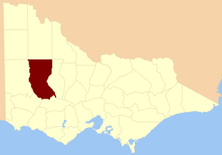
The Shire of Corio was a local government area located between Geelong and Werribee, about 60 kilometres (37 mi) southwest of Melbourne, the state capital of Victoria, Australia. The shire, which included all of Geelong's northern suburbs, covered an area of 704.66 square kilometres (272.1 sq mi), and existed from 1861 until 1993.
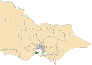
The electoral district of Bellarine is one of the electoral districts of Victoria, Australia, for the Victorian Legislative Assembly. It covers an area of 367 square kilometres (142 sq mi) stretching from the Bellarine Peninsula to the outer eastern suburbs of Geelong. It includes the towns of Barwon Heads, Clifton Springs, Drysdale, Indented Head, Ocean Grove, Point Lonsdale, Portarlington and Queenscliff and the Geelong suburbs of Leopold and Moolap. It lies within the Western Victoria Region of the upper house, the Legislative Council.
The Electoral district of Maryborough and Talbot was an electorate of the Victorian Legislative Assembly from 1877.

Emerald Hill was an electoral district of the Victorian Legislative Assembly, Australia. It covered part of the inner-city suburb South Melbourne and consisted part of the previous Electoral district of South Melbourne which was abolished in 1859..
South Yarra Province was an electorate of the Victorian Legislative Council from November 1882 until May 1904.
The electoral district of Borung was an electorate of the Victorian Legislative Assembly in the Australian colony of Victoria, which existed in two incarnations, from 1889 to 1927, and then from 1945 to 1955.

East Bourke Boroughs was an electoral district of the Legislative Assembly in the Australian state of Victoria from 1859 to 1904.

Geelong West was an electoral district of the Legislative Assembly in the Australian state of Victoria from 1859 to 1985. It was located west of the city of Geelong, defined in the Victorian Electoral Act, 1858 as:
Bounded on the north and north-west by a line drawn at a distance of 2 miles from the north-western angle of the town reserve of Geelong, as a centre from the western shore of Corio Bay, near Cowie's Creek, to a road leading to the River Barwon; on the west by that road; on the south-west and south by the River Barwon; and on the east by the western boundary of the town reserve of Geelong and the shores of Corio Bay, including the reserve at the junction of the Barwon and Moorabool
The Electoral district of Geelong was one of the original sixteen electoral districts of the old unicameral Victorian Legislative Council of 1851 to 1856. Victoria being a colony in Australia at the time.
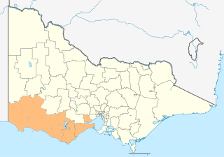
The Barwon South West is an economic rural region located in the southwestern part of Victoria, Australia. The Barwon South West region stretches from the tip of the Queenscliff Heads to the border of South Australia. It is home to Victoria’s largest provincial centre, Geelong and the major centres of Aireys Inlet, Apollo Bay, Camperdown, Colac, Hamilton, Lorne, Port Campbell, Port Fairy, Portland, Torquay and Warrnambool. It draws its name from the Barwon River and the geographic location of the region in the state of Victoria.