
The Electoral district of Colac was an electoral district of the Victorian Legislative Assembly, one of the inaugural districts of the first Assembly in 1856.
The Electoral district of Maryborough and Daylesford was an electoral district of the Victorian Legislative Assembly. It included the towns of Maryborough and Daylesford, around 168 km and 155 km north-west of Melbourne respectively.

Ararat was an electoral district of the Legislative Assembly in the Australian state of Victoria. The electorate was abolished in 1904 and replaced by the electoral district of Stawell and Ararat.

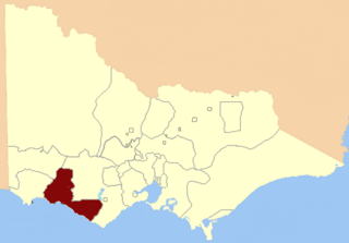
Dundas was an electoral district of the Legislative Assembly in the Australian state of Victoria from 1856 to 1976. It covered a region of western Victoria and consisted of the counties of Dundas and Follett.
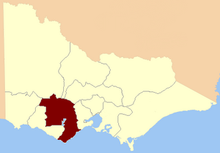
Villiers and Heytesbury was an electoral district of the Legislative Assembly in the Australian state of Victoria from 1856 to 1904. It was based in western Victoria, and included the area from Lake Corangamite along the coast westward past Port Fairy.

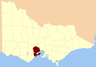
West Bourke was an electoral district of the Legislative Assembly in the Australian state of Victoria from 1856 to 1904.

Gippsland was an electoral district of the Legislative Assembly in the Australian state of Victoria from 1856 to 1859. From 1859, two new districts were created: South Gippsland and North Gippsland.
North Grant was an electoral district of the Legislative Assembly in the Australian state of Victoria from 1856 to 1859. It was bordered on the north by the Werribee River and included the town of Buninyong. The district of North Grant was one of the initial districts of the first Victorian Legislative Assembly, 1856. North Grant was incorporated into the electoral district of Grenville in 1859.

Polwarth, Ripon, Hampden and South Grenville was an electoral district of the Legislative Assembly in the Australian state of Victoria from 1856 to 1859. It was based in western Victoria.
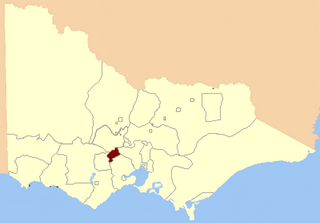
South Grant was an electoral district of the Legislative Assembly in the Australian state of Victoria from 1856 to 1877.

Talbot was an electoral district of the Legislative Assembly in the Australian colony of Victoria from 1856 to 1859. It was based in western Victoria, bounded on the west by Bet Bet Creek, the north by the Loddon River, on the east by the Coliban River and included the area around the towns of Creswick, Daylesford and Carisbrook.

Grenville was an electoral district of the Legislative Assembly in the Australian state of Victoria from 1859 to 1927. It was located in western Victoria, south of Ballarat.

Polwarth and South Grenville was an electoral district of the Legislative Assembly in the Australian state of Victoria from 1859 to 1889. It was based in western Victoria.

Ripon and Hampden was an electoral district of the Legislative Assembly in the Australian state of Victoria from 1859 to 1904. It was based in western Victoria.

The Electoral district of Gipps' Land was one of the original sixteen electoral districts of the old unicameral Victorian Legislative Council of 1851 to 1856. Victoria being a colony in Australia at the time.

The Electoral district of Normanby, Dundas and Follett was one of the original sixteen electoral districts of the old unicameral Victorian Legislative Council of 1851 to 1856. Victoria being a colony on the continent of Australia at the time.

The Electoral district of North Bourke was one of the original sixteen electoral districts of the old unicameral Victorian Legislative Council of 1851 to 1856. Victoria being a colony in Australia at the time.
The Electoral district of Ripon, Hampden, Grenville and Polwarth was one of the original sixteen electoral districts of the old unicameral Victorian Legislative Council of 1851 to 1856. Victoria being a colony in Australia at the time.

The Electoral district of Villiers and Heytesbury was one of the original sixteen electoral districts of the old unicameral Victorian Legislative Council of 1851 to 1856. Victoria being a colony in Australia at the time.

This is a list of members of the Victorian Legislative Assembly from the elections of 26 August – 26 September 1859 to the elections of 2 – 19 August 1861.
