
Electoral districts of Victoria are the electoral districts, commonly referred to as "seats" or "electorates", into which the Australian State of Victoria is divided for the purpose of electing members of the Victorian Legislative Assembly, one of the two houses of the Parliament of the State. The State is divided into 88 single-member districts. The Legislative Assembly has had 88 electorates since the 1985 election, increased from 81 previously.

Fisher was an electoral district of the House of Assembly in the Australian state of South Australia. It was created in 1970 and named after Sir James Fisher, a colonial politician and the first mayor of Adelaide. It was abolished in a 2016 redistribution and its last MP, Nat Cook was elected to represent its replacement, Hurtle Vale, at the 2018 state election. It covers a 94.2 km2 suburban and semi rural area on the southern fringes of Adelaide, taking in the suburbs of Aberfoyle Park, Chandlers Hill, Cherry Gardens, Coromandel East, Happy Valley, Reynella East and parts of Clarendon, O'Halloran Hill and Woodcroft.

The 2002 Victorian state election, held on Saturday, 30 November 2002, was for the 55th Parliament of Victoria. It was held to elect the 88 members of Victorian Legislative Assembly and 22 members of the 44-member Legislative Council.
The electoral district of Burwood was an electorate for the Victorian Legislative Assembly in Australia. It was located approximately 13 kilometres east of Melbourne, and covered an area of 25 km2. The seat included the suburbs of Ashburton, Ashwood, Box Hill South, Burwood, Chadstone, and parts of Camberwell, Canterbury, Glen Iris, and Surrey Hills. It was created in 1955 as part of the expansion of the Legislative Assembly, and abolished in 1967, replaced by Glen Iris. Burwood was recreated in 1976, replacing Glen Iris.

The electoral district of Bass is one of the electoral districts of Victoria, Australia, for the Victorian Legislative Assembly. It covers an area of 1,358 square kilometres (524 sq mi) south east of Melbourne, stretching from the satellite suburb of Clyde through rural areas to the coast at Inverloch and Phillip Island. It includes the suburbs and towns of Bass, Cape Paterson, Clyde, Corinella, Cowes, Grantville, Inverloch, Kilcunda, Koo Wee Rup, Lang Lang, Pearcedale, Rhyll, San Remo, Tooradin, Ventnor and Wonthaggi. It lies within the Eastern Victoria Region of the upper house, the Legislative Council.
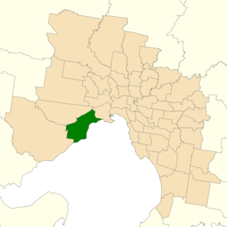
The electoral district of Altona was one of the electoral districts of Victoria, Australia, for the Victorian Legislative Assembly. It covered an area of 79 square kilometres (31 sq mi) in western Melbourne, and included the suburbs of Altona, Altona Meadows, Laverton, Point Cook, Seabrook and Seaholme. It also included the RAAF Williams airbase and the Point Cook Coastal Park. It lay within the Western Metropolitan Region of the upper house, the Legislative Council.

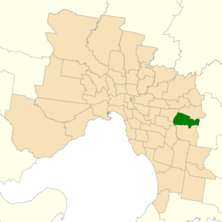
The electoral district of Bayswater is one of the electoral districts of Victoria, Australia, for the Victorian Legislative Assembly. It covers an area of 39 square kilometres (15 sq mi) in outer eastern Melbourne, and includes the suburbs of Bayswater, Heathmont, Kilsyth South and The Basin, and parts of Bayswater North, Boronia, Ringwood and Wantirna. It lies within the Eastern Metropolitan Region of the upper house, the Legislative Council.

The electoral district of Narre Warren North is an electorate of the Victorian Legislative Assembly and includes the suburbs of Hallam, Narre Warren, Narre Warren North and parts of Berwick, Endeavour Hills and Harkaway.

The electoral district of Dandenong is an electoral district of the Victorian Legislative Assembly. It was first proclaimed in 1904 when the district of Dandenong and Berwick was abolished.
The electoral district of Ferntree Gully was an electorate of the Victorian Legislative Assembly. It was created in 2002 as a replacement for the abolished electorate of Knox.
The electoral district of Frankston is an electoral district of the Victorian Legislative Assembly. It currently includes the suburbs of Frankston and Frankston South south east of Melbourne.

The electoral district of Mount Waverley was an electoral district of the Victorian Legislative Assembly. It was located in the south-eastern suburbs of Melbourne and contained the suburbs of Glen Waverley and Mount Waverley.

The electoral district of Tarneit is an electoral district of the Victorian Legislative Assembly. It was created before the 2002 election where it replaced the seat of Werribee.
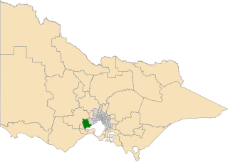
Lara is a seat in the Victorian Legislative Assembly. It covers much of the area between the western suburbs of Melbourne and the regional city of Geelong. Most of the voters come from the very northern suburbs of Geelong, including Lara, Bell Post Hill and Corio. The district also includes the country towns of Anakie, Balliang and Little River but these add very few voters to the district.

The electoral district of Melbourne is an electorate of the Victorian Legislative Assembly. It currently includes the localities of Docklands, Carlton, Melbourne, East Melbourne, West Melbourne, North Melbourne, Parkville, Newmarket, Kensington and Flemington, and includes Melbourne University. The district has been in existence since 1856.

The electoral district of Yuroke was an electoral district of the Victorian Legislative Assembly. It was situated in the outer northern suburbs of Melbourne and was created in a redistribution before the 2002 state election, replacing the former electorate of Tullamarine.
Robert Logan Dean Australian politician is a former member of the Victorian Legislative Assembly.

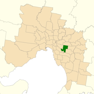
Forest Hill was an electoral district of the Legislative Assembly in the Australian state of Victoria. It was a 25 km² electorate located in the eastern suburbs of Melbourne, encompassing the suburbs of Blackburn South, Burwood East and Vermont South and parts of Forest Hill and Vermont. The electorate had a population of 50,163 as of the 2006 census.

The electoral district of Berwick is an electoral district of the Legislative Assembly in the Australian state of Victoria.
The electoral district of Ringwood is an electoral district of the Victorian Legislative Assembly, located in the east of Melbourne. It was first proclaimed in 1958 and was abolished in 1992. Some of Ringwood was included in the new electoral district of Bayswater that year. Kay Setches, who was at the time the last member for Ringwood, contested and lost Bayswater at the 1992 election.
