The City of Whitehorse is a local government area in Victoria, Australia in the eastern suburbs of Melbourne. It has an area of 64 km2 (25 sq mi) and in June 2018, Whitehorse had a population of 176,196.
Electoral district of Ormond was an electoral district of the Legislative Assembly in the Australian state of Victoria.
Electoral district of Moorabbin was an electoral district of the Legislative Assembly in the Australian state of Victoria.
Electoral district of Heatherton was an electoral district of the Legislative Assembly in the Australian state of Victoria.
The electoral district of Springvale was an electoral district of the Legislative Assembly in the Australian state of Victoria. It was replaced in 2002, by the electoral districts of Lyndhurst and Mulgrave.
Electoral district of Clifton Hill was an electoral district of the Legislative Assembly in the Australian state of Victoria. It centred on the north-eastern Melbourne suburb of Clifton Hill.
Electoral district of Dandenong North was an electoral district of the Legislative Assembly in the Australian state of Victoria.
Electoral district of Noble Park was an electoral district of the Legislative Assembly in the Australian state of Victoria.
Electoral district of Reservoir was an electoral district of the Legislative Assembly in the Australian state of Victoria.
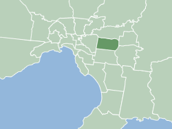
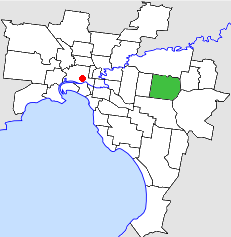
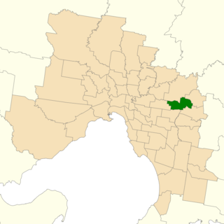
Electoral district of Syndal was an electoral district of the Legislative Assembly in the Australian state of Victoria.
The electoral district of Yarraville was a district of the Legislative Assembly in the Australian state of Victoria.
The Electoral district of Whittlesea was an electoral district of the Legislative Assembly in the Australian state of Victoria.
The City of Nunawading was a local government area about 20 kilometres (12 mi) east of Melbourne, the state capital of Victoria, Australia. The city covered an area of 41.61 square kilometres (16.07 sq mi), and existed from 1925 until 1994.

The electoral district of Anglesey was an electoral district of the Legislative Assembly in the Australian state of Victoria.
The electoral district of Mooroolbark was an electoral district of the Legislative Assembly in the Australian state of Victoria.
Nunawading Province was an electorate of the Victorian Legislative Council. It was created in 1976, based in the outer eastern Melbourne suburbs including Nunawading. It was finally abolished 29 March 1996. Much of its area was replaced by Koonung Province.
South Eastern Province was an electorate of the Victorian Legislative Council from November 1882. It was created in the redistribution of provinces in 1882 when the original provinces of Central and Eastern were abolished. The new South Eastern, South Yarra, North Yarra, North Eastern, North Central, Melbourne East, Melbourne North, Melbourne South and Melbourne West Provinces were then created.
Melbourne East Province was an electorate of the Victorian Legislative Council.

The Electoral district of South Bourke was an electoral district of the Legislative Assembly in then Australian colony of Victoria. It was one of the original 36 electoral districts of the Assembly. It covered an area east of Melbourne, bounded by Dandenong Creek in the south and east, Moorabbin, Prahran and Hawthorn in the west and Templestowe in the north. It was abolished in 1889.
The electoral district of Ringwood is an electoral district of the Victorian Legislative Assembly. It was first proclaimed in 1958 and was abolished in 1992. The electorate was located to the east of Melbourne and centred on the suburb of Ringwood, after which it is named.