
The Electoral district of Colac was an electoral district of the Victorian Legislative Assembly, one of the inaugural districts of the first Assembly in 1856.
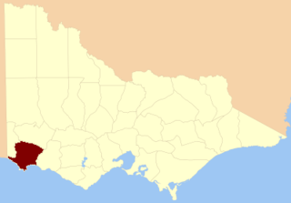
The Electoral district of Normanby was an electoral district in the Legislative Assembly of Victoria, it covered an area from the South Australian border to Portland Bay.
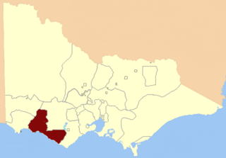
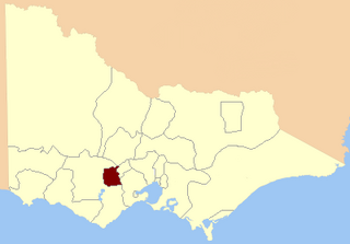
Hampden was an electoral district of the Legislative Assembly in the Australian state of Victoria from 1904 until its abolition in 1976. Most of the territory located in the old division of Hampden was transferred into the re-created electorate of Ripon. Hampden's most notable member was the longest serving Premier of Victoria Sir Henry Bolte. The seat was a marginally conservative seat, having never been won by the non-conservative parties for more than one term.

Members of the Victorian Legislative Council, the upper house of the Parliament of the Australian State of Victoria, are elected from eight multi-member electorates called regions. The Legislative Council has 40 members, five from each of the eight regions.
Nelson Province was an electorate of the Victorian Legislative Council (Australia). It was created in the wide-scale redistribution of Provinces 1882 when Central and Eastern Provinces were abolished and ten new Provinces were created. Its area included Camperdown, Ararat and Mortlake.

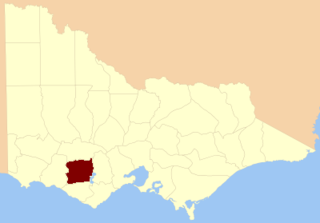
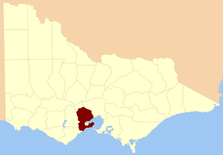
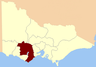
Dundas was an electoral district of the Legislative Assembly in the Australian state of Victoria from 1856 to 1976. It covered a region of western Victoria and consisted of the counties of Dundas and Follett.
Villiers and Heytesbury was an electoral district of the Legislative Assembly in the Australian state of Victoria from 1856 to 1904. It was based in western Victoria, and included the area from Lake Corangamite along the coast westward past Port Fairy.

Gippsland was an electoral district of the Legislative Assembly in the Australian state of Victoria from 1856 to 1859. From 1859, two new districts were created: South Gippsland and North Gippsland.
North Grant was an electoral district of the Legislative Assembly in the Australian state of Victoria from 1856 to 1859. It was bordered on the north by the Werribee River and included the town of Buninyong. The district of North Grant was one of the initial districts of the first Victorian Legislative Assembly, 1856. North Grant was incorporated into the electoral district of Grenville in 1859.
North Grenville was an electoral district of the Legislative Assembly in the Australian state of Victoria from 1856 to 1859. It was bordered on the east by the Yarrowee River and included an area south of Ballarat. The short-lived, rural district of North Grenville was one of the initial districts of the first Victorian Legislative Assembly, 1856.

Polwarth, Ripon, Hampden and South Grenville was an electoral district of the Legislative Assembly in the Australian state of Victoria from 1856 to 1859. It was based in western Victoria.
South Grant was an electoral district of the Legislative Assembly in the Australian state of Victoria from 1856 to 1877.

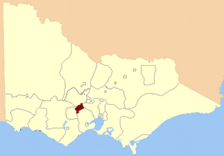
Grenville was an electoral district of the Legislative Assembly in the Australian state of Victoria from 1859 to 1927. It was located in western Victoria, south of Ballarat.

Polwarth and South Grenville was an electoral district of the Legislative Assembly in the Australian state of Victoria from 1859 to 1889. It was based in western Victoria.

The Electoral district of Normanby, Dundas and Follett was one of the original sixteen electoral districts of the old unicameral Victorian Legislative Council of 1851 to 1856. Victoria being a colony on the continent of Australia at the time.
The Electoral district of Ripon, Hampden, Grenville and Polwarth was one of the original sixteen electoral districts of the old unicameral Victorian Legislative Council of 1851 to 1856. Victoria being a colony in Australia at the time.

The Electoral district of Villiers and Heytesbury was one of the original sixteen electoral districts of the old unicameral Victorian Legislative Council of 1851 to 1856. Victoria being a colony in Australia at the time.

This is a list of members of the Victorian Legislative Assembly from the elections of 26 August – 26 September 1859 to the elections of 2 – 19 August 1861.

Colin Campbell was a pastoralist and politician in colonial Victoria, a member of the Victorian Legislative Council, and later, the Victorian Legislative Assembly.
Jeremiah George Ware was a pastoralist and politician in colonial Victoria, a member of the Victorian Legislative Assembly.
