External links
| | This Victoria (Australia) government-related article is a stub. You can help Wikipedia by expanding it. |
| Murray Valley Victoria—Legislative Assembly | |
|---|---|
| State | Victoria |
| Created | 1945 |
| Abolished | 2014 |
| Electors | 38,342 (2010) |
| Area | 5,020 km2 (1,938.2 sq mi) |
| Demographic | Rural |
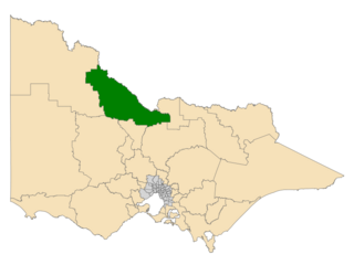
The Electoral district of Murray Valley was an electoral district of the Victorian Legislative Assembly.
It contained the towns of Cobram, Numurkah, Rutherglen, Wangaratta and Yarrawonga, as well as many other smaller towns.
The electorate was created in 1945 and abolished in 2014. For the entirety of existence it was held by the National Party and its predecessors.
| Member | Party | Term | |
|---|---|---|---|
| George Moss | Country | 1945–1973 | |
| Bill Baxter | Country | 1973–1975 | |
| National Country | 1975–1976 | ||
| Ken Jasper | National Country | 1976–1982 | |
| National | 1982–2010 | ||
| Tim McCurdy | National | 2010–2014 | |
| Party | Candidate | Votes | % | ±% | |
|---|---|---|---|---|---|
| National | Tim McCurdy | 18,357 | 53.83 | +2.92 | |
| Labor | Lachlan Enshaw | 7,065 | 20.72 | -1.20 | |
| Independent | Roberto Paino | 3,339 | 9.79 | +9.79 | |
| Country Alliance | Peter Watson | 2,668 | 7.82 | +7.82 | |
| Greens | Doug Ralph | 1,598 | 4.69 | -0.75 | |
| Family First | Ray Hungerford | 1,073 | 3.15 | -1.00 | |
| Total formal votes | 34,100 | 94.87 | -1.43 | ||
| Informal votes | 1,845 | 5.13 | +1.43 | ||
| Turnout | 35,945 | 93.75 | +0.59 | ||
| Two-party-preferred result | |||||
| National | Tim McCurdy | 23,604 | 69.04 | -2.72 | |
| Labor | Lachlan Enshaw | 10,587 | 30.96 | +2.72 | |
| National hold | Swing | -2.72 | |||
| | This Victoria (Australia) government-related article is a stub. You can help Wikipedia by expanding it. |

Tocumwal is a town in the southern Riverina region of New South Wales, Australia, in the Berrigan Shire local government area, near the Victorian border. The town is situated on the banks of the Murray River, 270 kilometres (170 mi) north of the city of Melbourne. The Newell Highway and Murray Valley Highway join at the Murray River, and form part of the main road route National Highway A39 between Brisbane and Melbourne. At the 2016 census, Tocumwal had a population of 2,682. The winner of several 'Tidy Town' awards, Tocumwal is affectionately known as 'The Jewel in the Crown That Is The Riverina District'.

The Riverina is an agricultural region of south-western New South Wales, Australia. The Riverina is distinguished from other Australian regions by the combination of flat plains, warm to hot climate and an ample supply of water for irrigation. This combination has allowed the Riverina to develop into one of the most productive and agriculturally diverse areas of Australia. Bordered on the south by the state of Victoria and on the east by the Great Dividing Range, the Riverina covers those areas of New South Wales in the Murray and Murrumbidgee drainage zones to their confluence in the west.

Electoral districts of Victoria are the electoral districts, commonly referred to as "seats" or "electorates", into which the Australian State of Victoria is divided for the purpose of electing members of the Victorian Legislative Assembly, one of the two houses of the Parliament of the State. The State is divided into 88 single-member districts. The Legislative Assembly has had 88 electorates since the 1985 election, increased from 81 previously.

The Goulburn Valley is a sub-region, part of the Hume region of the Australian state of Victoria. The sub-region consists of those areas in the catchment of the Goulburn River and other nearby streams, and is part of the Murray-Darling Basin. The Goulburn Valley is bordered on the south by the Great Dividing Range and to the north by the Murray River, the state border with New South Wales. The sub-region is one of Australia's most productive and intensively farmed areas and is predominantly irrigated.

The Electoral district of Rodney was a Victorian Legislative Assembly electorate in Northern Victoria.

The electoral district of Narracan is an electoral district of the Victorian Legislative Assembly in Australia. It was first proclaimed in 1967 and has usually been held by the Liberal Party.

Northern Victoria Region is one of the eight electoral regions of Victoria, Australia, which elects five members to the Victorian Legislative Council by proportional representation. The region was created in 2006 following the 2005 reform of the Victorian Legislative Council.
The Electoral district of Swan Hill was a rural Lower House electoral district of the Victorian Parliament. It was located within the Northern Victoria Region of the Legislative Council.

Ripon is a single member electoral district of the Victorian Legislative Assembly. It is a rural electorate based in western Victoria. In 1946 the electoral district of Ripon was first contested but then abolished in the 1955 election after being held by Labor for seven of these years. Ripon was re-created in 1976, essentially as a replacement for Hampden.

The Electoral district of Mandurang was an electoral district of the Victorian Legislative Assembly (Australia), based in north central Victoria around, but not including, the town of Bendigo.
The Electoral district of Gunbower was an electoral district of the Victorian Legislative Assembly. It was created by The Electoral Act Amendment Act 1888 taking effect at the 1889 elections. The district was bound by the County of Bendigo and the Loddon, Murray and Campaspe Rivers.
The Electoral district of Murray is a state electoral district of the New South Wales Legislative Assembly.
This is a list of electoral results for the Electoral district of Murray Valley in Victorian state elections.

The Murray was an electoral district of the Legislative Assembly in the Australian colony of Victoria from 1856 to 1877.

Murray Boroughs was an electoral district of the Legislative Assembly in the Australian state of Victoria from 1856 to 1877. It was based in northern Victoria, and included the towns of Benalla Avenel Euroa Seymour, Wodonga and Wangaratta. The district of Murray Boroughs was one of the initial districts of the first Victorian Legislative Assembly, 1856.

The Electoral district of Murray was one of the sixteen electoral districts of the original unicameral Victorian Legislative Council of 1851 to 1856.

Avoca was an electoral district of the Legislative Assembly in the Australian state of Victoria from 1859 to 1889. It was based in northern Victoria. It was defined by the 1858 Electoral Act as:
Commencing at the source of the River Avoca in the Main Dividing Range ; thence northwards by that river and by a line bearing north to the River Murray ; thence by the River Murray to the River Loddon; thence south-wards by the River Loddon to McNeil's Creek; thence by McNeil's Creek to the Main Dividing Range; and thence westerly by the Main Dividing Range to the commencing point aforesaid, including the parish of Tarnagulla.
The electoral district of Murray Plains is an electoral district of the Victorian Legislative Assembly in Australia. It was created in the redistribution of electoral boundaries in 2013, and came into effect at the 2014 state election.

The electoral district of Ovens Valley is an electoral district of the Victorian Legislative Assembly in Australia. It was created in the redistribution of electoral boundaries in 2013, and came into effect at the 2014 state election.