
The electoral district of Brighton is an electoral district of the Victorian Legislative Assembly. It covers an area of 19 square kilometres (7.3 sq mi) in south-eastern Melbourne, including the suburbs of Brighton and Elwood, and parts of Brighton East and Hampton. It lies within the Southern Metropolitan Region of the upper house, the Legislative Council.

The electoral district of Melbourne is an electorate of the Victorian Legislative Assembly. It currently includes the localities of Carlton, North Carlton, Melbourne, East Melbourne, West Melbourne, North Melbourne, Parkville, Newmarket, Kensington and Flemington, and includes Melbourne University. The district has been in existence since 1856.

Bendigo East is an electoral district of the Legislative Assembly in the Australian state of Victoria. It covers an area of 2,711 square kilometres (1,047 sq mi) covering the part of the city of Bendigo east of the Yungera railway line and surrounding rural areas to the north, east and south. It includes the Bendigo suburbs of East Bendigo, Epsom, Flora Hill, Junortoun, Kennington, Quarry Hill, Spring Gully, Strathdale, Strathfieldsaye and White Hills, and the surrounding towns of Axedale, Goornong, Huntly, Mandurang, Raywood and Sedgwick. It also includes parts of the localities of Eaglehawk, Elmore, Golden Square and Ravenswood, and the Bendigo campus of La Trobe University. It lies within the Northern Victoria Region of the upper house, the Legislative Council.
The Electoral district of Donald and Swan Hill was an electoral district of the Victorian Legislative Assembly. It was created by the Electoral Act Amendment Act 1888, taking effect at the 1889 elections. It was abolished by the Victorian Electoral Districts Boundaries Act 1903.
The Electoral district of Maryborough and Talbot was an electorate of the Victorian Legislative Assembly from 1877.

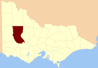
The Electoral district of Maryborough was an electorate of the Victorian Legislative Assembly based on an area around Maryborough, Victoria. It was created in the expansion of the Assembly by the Victorian Electoral Act, 1858, which took effect at the election in 1859.

Ararat was an electoral district of the Legislative Assembly in the Australian state of Victoria. The electorate was abolished in 1904 and replaced by the electoral district of Stawell and Ararat.
The Electoral district of Korong was an electoral district of the Legislative Assembly in the Australian state of Victoria.
The electoral district of Borung was an electorate of the Victorian Legislative Assembly in the Australian colony of Victoria, which existed in two incarnations, from 1889 to 1927, and then from 1945 to 1955.

Collingwood was an electoral district of the Legislative Assembly in the Australian state of Victoria from 1856 to 1958. It centred on the Melbourne suburb of Collingwood, Victoria.
East Bourke Boroughs was an electoral district of the Legislative Assembly in the Australian state of Victoria from 1859 to 1904.
Kilmore was an electoral district of the Legislative Assembly in the Australian state of Victoria centred on Kilmore from 1856 to 1877. It was superseded in 1877 by Kilmore and Anglesey.
Loddon was an electoral district of the Legislative Assembly in the Australian state of Victoria from 1856 to 1859. It was based in northern Victoria around the Loddon River.

Ovens was an electoral district of the Legislative Assembly in the Australian state of Victoria from 1856 to 1927. It was based in northern Victoria, bordered by the Ovens River in the south-west and included the town of Beechworth, Victoria.

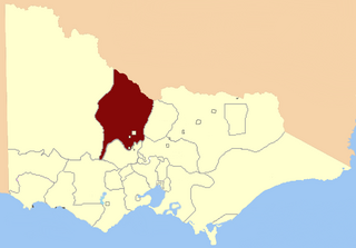
Avoca was an electoral district of the Legislative Assembly in the Australian state of Victoria from 1859 to 1889. It was based in northern Victoria. It was defined by the 1858 Electoral Act as:
Commencing at the source of the River Avoca in the Main Dividing Range ; thence northwards by that river and by a line bearing north to the River Murray ; thence by the River Murray to the River Loddon; thence south-wards by the River Loddon to McNeil's Creek; thence by McNeil's Creek to the Main Dividing Range; and thence westerly by the Main Dividing Range to the commencing point aforesaid, including the parish of Tarnagulla.

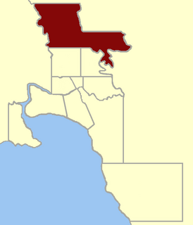
Dalhousie was an electoral district of the Legislative Assembly in the Australian state of Victoria from 1859 to 1927. It was based in north-western Victoria. The district had been named Electoral district of Anglesey. The district of Dalhousie was defined in the 1858 Electoral Act as :
THE ELECTORAL DISTRICT OF DALHOUSIE.
ANGLESEY. Bounded on the west by part of the eastern boundary of the County of Dalhousie, namely, by the River Goulburn from the confluence of Hughes's Creek to the confluence of Dabyminga Creek; thence by Dabyminga Creek to its source in the Great Dividing Range; on the south by the Great Dividing Range to the main source of the River Goulburn; on the east by the range dividing the waters of the main source of the Goulburn and Big Rivers from those of the Rubicon and Snod-por-dock Creek northward to Mount Torbrick; thence by Jerusalem Creek to its confluence with the River Goulburn; thence by the River Goulburn to the confluence of the River Delatite; thence by the River Delatite and its north-west arm to the Dividing Range between the last named arm and Septimus Creek; and on the north by that range to the source of Hughes's Creek; and thence by Hughes's Creek to its confluence with the River Goulburn, excepting the country included in the Boroughs of Seymour and Avenel ... DALHOUSIE. Commencing at the junction of the Rivers Campaspe and Coliban; thence by a line south-easterly to the source of the Mclvor or Patterson's Creek; thence by a line north-east to the confluence of Hughes's Creek with the River Goulburn; on the east by the River Goulburn until it joins the Dabyminga Creek, by that creek to its source in the Dividing Range; on
the south by the Dividing Range to the source of the River Coliban; and on the west by the last mentioned river to its junction with the River Campaspe, being the commencing point, excepting the country included in the electoral districts of the Kyneton Boroughs, Murray Boroughs, and Kilmore.

Geelong East was an electoral district of the Legislative Assembly in the Australian state of Victoria from 1859 to 1985. It was located south of the city of Geelong, defined in the Victorian Electoral Act, 1858 as:
Commencing at the north-western angle of the town reserve of Geelong; thence by a line south to the River Barwon; thence westward and northwestward by the River Barwon to the western boundary of the reserve at the junction of the Moorabool and Barwon; thence east by the northern boundary of section 25, parish of Barrabool; thence south by the eastern boundaries of sections 25 and 11, and by part of the eastern boundary of section 7, all in the same parish; thence south-easterly by a curved line crossing the Waurn Chain of Ponds to the southern boundary of section 3, parish of Conewarre; thence east by the southern boundaries of sections 3 and 4 in the same parish; thence north-easterly by a curved line crossing the River Barwon to the south-eastern angle of section 11 in the parish of Moolap; thence by the eastern boundary of that section and a line north to the shores of Corio Bay; and thence by the shores of Corio Bay to the north-western angle of the town reserve, the commencing point aforesaid, including the remaining portion of the reserve at Point Henry.
Sandhurst South was an electoral district of the Legislative Assembly in the Australian state of Victoria from 1889 to 1904. It was based on an area south of the town of Sandhurst south-east of High street and the south west of Russell-street, Strathfieldsaye shire and most of Marong shire.

This is a list of members of the Victorian Legislative Assembly from the elections of 26 August – 26 September 1859 to the elections of 2 – 19 August 1861.
This is a list of members of the Victorian Legislative Assembly, from the elections of 11 May 1877. Victoria was a British self-governing colony in Australia at the time.
