Electoral district of Lowan

Last updated

Lowan
VictoriaLegislative Assembly
Electoral district of Lowan (Victoria) 2022.svg
Location of Lowan (dark green) in Victoria
State Victoria
Dates current1889–1945
1955–1992
2002–present
MP Emma Kealy
Party The Nationals
Electors 51,182 (2022)
Area41,858 km2 (16,161.5 sq mi)
DemographicRural
Coordinates 37°S142°E / 37°S 142°E / -37; 142
Electorates around Lowan:
South Australia Mildura Mildura
South Australia Lowan Ripon
South Australia South-West Coast Polwarth

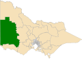
The electoral district of Lowan is a rural Victorian Legislative Assembly (Lower House) electoral district of the Victorian Parliament. It is located within the Western Victoria Region of the Legislative Council. It was initially created by the Electoral Act Amendment Act 1888, [1] taking effect at the 1889 elections. It is the state’s biggest electorate by area, covering about 41,858 km².

Contents

Lowan includes the country towns of Casterton, Coleraine, Dartmoor, Dimboola, Hamilton, Horsham, Jeparit, Kaniva, Nhill and Rainbow. The current seat was established in 2002 although several previous seats held the same name.

The current member is The Nationals' Emma Kealy.

Members for Lowan

First incarnation (1889–1945)
MemberPartyTerm
  Richard Baker Unaligned1889–1894
 Sir William Irvine Unaligned1894–1906
  Robert Stanley Ministerialist1906–1911
  Comm Liberal
  James Menzies Comm Liberal 1911–1920
  Nationalist
  Marcus Wettenhall Farmers Union 1920–1935
  Country
  Hamilton Lamb Country 1935–1943
  Wilfred Mibus Country 1944–1945
Second incarnation (1955–1992)
MemberPartyTerm
  Wilfred Mibus Liberal and Country 1955–1964
  Jim McCabe Liberal 1964–1967
  Ray Buckley Country 1967–1970
  Jim McCabe Liberal 1970–1979
  Bill McGrath National Country 1979–1982
  The Nationals 1982–1992
Third incarnation (2002–present)
MemberPartyTerm
  Hugh Delahunty The Nationals 2002–2014
  Emma Kealy The Nationals 2014–present

Election results

2022 Victorian state election: Lowan [2] [3] [4] [5]
PartyCandidateVotes%±%
National Emma Kealy 25,48259.0–0.7
Labor Mick Monaghan8,45419.6−1.8
Greens Richard Lane2,5756.0+0.6
Independent Amanda Mead2,3845.5+5.5
Angry Victorians Richard Etherton1,7103.9+3.9
Family First Robert Coleman1,5733.6+3.6
Animal Justice Tamasin Ramsay1,0192.4+2.1
Total formal votes43,24094.3−0.5
Informal votes2,6225.7+0.5
Turnout 45,86289.7+1.1
Two-party-preferred result
National Emma Kealy 30,94171.6+0.5
Labor Mick Monaghan12,29928.4−0.1
National hold Swing +0.5

See also

Related Research Articles

<span class="mw-page-title-main">Electoral district of Malvern</span> State electoral district of Victoria, Australia

The electoral district of Malvern is an electorate of the Victorian Legislative Assembly. It contains the suburbs of Malvern, Armadale, Kooyong, Malvern East, Toorak, and parts of Glen Iris.

<span class="mw-page-title-main">Electoral district of Bayswater</span> State electoral district of Victoria, Australia

The electoral district of Bayswater is one of the electoral districts of Victoria, Australia, for the Victorian Legislative Assembly. It covers an area of 39 square kilometres (15 sq mi) in outer eastern Melbourne, and includes the suburbs of Bayswater, Heathmont, Kilsyth South and The Basin, and parts of Bayswater North, Boronia, Ringwood and Wantirna. It lies within the Eastern Metropolitan Region of the upper house, the Legislative Council.

<span class="mw-page-title-main">Electoral district of Hawthorn</span> State electoral district of Victoria, Australia

The electoral district of Hawthorn is an electoral district of the Victorian Legislative Assembly. It was first proclaimed in 1888 taking effect at the 1889 elections.

<span class="mw-page-title-main">Electoral district of Yan Yean</span> State electoral district of Victoria, Australia

The electoral district of Yan Yean is an electoral district of the Victorian Legislative Assembly. It is located on the fringes of Melbourne's northern suburbs and contains the towns of Hurstbridge, Plenty, Whittlesea and Yan Yean.

<span class="mw-page-title-main">Electoral district of Thomastown</span> State electoral district of Victoria, Australia

The electoral district of Thomastown is an electorate of the Victorian Legislative Assembly. It currently includes the suburbs of Lalor and Thomastown, and parts of Fawkner, Reservoir and Wollert, and has been in existence since 1985.

<span class="mw-page-title-main">Electoral district of Evelyn</span> State electoral district of Victoria, Australia

The electoral district of Evelyn is an electorate of the Victorian Legislative Assembly covering the urban fringe north east of Melbourne. It was first proclaimed in 1859.

<span class="mw-page-title-main">Electoral district of South-West Coast</span> State electoral district of Victoria, Australia

The electoral district of South-West Coast is an electorate of the Victorian Legislative Assembly. It was created prior to the 2002 election in order to replace the abolished seats of Portland and Warrnambool.

<span class="mw-page-title-main">Electoral district of Kororoit</span> State electoral district of Victoria, Australia

The electoral district of Kororoit is an electorate of the Victorian Legislative Assembly covering Albanvale, Caroline Springs as well as some parts of Deer Park and St Albans in the western suburbs of Melbourne.

<span class="mw-page-title-main">Electoral district of Warrandyte</span> State electoral district of Victoria, Australia

The electoral district of Warrandyte is an Australian electoral district of the Victorian Legislative Assembly. It is an outer metropolitan electorate and contains the suburbs of Park Orchards, Ringwood North, Warrandyte, Warrandyte North, Warrandyte South, Warranwood, Wonga Park, most of Donvale, and parts of Chirnside Park, Doncaster East, and Ringwood.

<span class="mw-page-title-main">Electoral district of Brunswick</span> State electoral district of Victoria, Australia

The electoral district of Brunswick is an electorate of the Victorian Legislative Assembly. It covers an area of 14 square kilometres (5.4 sq mi) in inner northern Melbourne, and includes the suburbs of Brunswick, Brunswick East, Carlton North, Fitzroy North, Princes Hill and parts of Brunswick West. It lies within the Northern Metropolitan Region of the upper house, the Legislative Council.

<span class="mw-page-title-main">Electoral district of Geelong</span> State electoral district of Victoria, Australia

The electoral district of Geelong is an electoral district of the Victorian Legislative Assembly. It centres on inner metropolitan Geelong and following the June 2013 redistribution of electoral boundaries includes the suburbs of Belmont, Breakwater, East Geelong, Geelong, Geelong West, Newtown and South Geelong, Herne Hill, Manifold Heights, Newcomb, Newtown, St Albans Park, Thomson, Whittington and part of Fyansford.

<span class="mw-page-title-main">Electoral district of Prahran</span> State electoral district of Victoria, Australia

Prahran is an electoral district of the Legislative Assembly in the Australian state of Victoria. It was created by the Electoral Act Amendment Act 1888, taking effect at the 1889 elections. The electorate is the state’s smallest by area, covering a little under 11 km² in the inner south-east of Melbourne. It includes the suburbs of South Yarra, Prahran and Windsor, as well as parts of Southbank, St Kilda and St Kilda East.

<span class="mw-page-title-main">Electoral district of Williamstown</span> State electoral district of Victoria, Australia

Williamstown is an electoral district of the Legislative Assembly in the Australian state of Victoria. It is a 33 km2 urban electorate in the inner south-western suburbs of Melbourne, encompassing the suburbs of Brooklyn, Newport, Spotswood, Williamstown, Williamstown North, South Kingsville, Seaholme, Altona and Yarraville. The electorate had a population of 54,426 as of the 2006 census.

<span class="mw-page-title-main">Electoral district of Melbourne</span> State electoral district of Victoria, Australia

The electoral district of Melbourne is an electorate of the Victorian Legislative Assembly. It currently includes the localities of Docklands, Carlton, Melbourne, East Melbourne, West Melbourne, North Melbourne, Parkville, Newmarket, Kensington and Flemington, and includes Melbourne University. The district has been in existence since 1856.

<span class="mw-page-title-main">Electoral district of Oakleigh</span> State electoral district of Victoria, Australia

The electoral district of Oakleigh is an electoral district of the Victorian Legislative Assembly. It covers the south-east Melbourne suburbs of Carnegie, Murrumbeena, Hughesdale, Notting Hill, Oakleigh East, Oakleigh and parts of Chadstone, Glen Waverley, Mount Waverley, Glen Huntly, Mulgrave and Ormond.

<span class="mw-page-title-main">Electoral district of Broadmeadows</span> State electoral district of Victoria, Australia

The electoral district of Broadmeadows is an electorate of the Victorian Legislative Assembly. It covers an area of 47 square kilometres (18 sq mi) in outer northern Melbourne, and includes the suburbs of Broadmeadows, Campbellfield, Coolaroo, Dallas, Fawkner, Jacana and Meadow Heights. It also includes parts of Glenroy, Roxburgh Park, Somerton, and Westmeadows. It lies within the Northern Metropolitan Region of the upper house, the Legislative Council.

<span class="mw-page-title-main">Electoral district of Gippsland South</span> State electoral district of Victoria, Australia

The electoral district of Gippsland South is a Lower House electoral district of the Victorian Parliament. It is located within the Eastern Victoria Region of the Legislative Council.

<span class="mw-page-title-main">Electoral district of Footscray</span> State electoral district of Victoria, Australia

The electoral district of Footscray is an electoral district of the Victorian Legislative Assembly. It lies just north of Melbourne, covering the suburbs of Footscray, Maidstone, Maribyrnong, Seddon, West Footscray, and parts of Yarraville.

<span class="mw-page-title-main">Electoral district of Sandringham</span> State electoral district of Victoria, Australia

The electoral district of Sandringham is one of the electoral districts of Victoria, Australia, for the Victorian Legislative Assembly. It consists of the Melbourne bayside suburbs of Beaumaris, Black Rock and Sandringham, and parts of Cheltenham, Hampton, Highett, and Mentone.

<span class="mw-page-title-main">Electoral district of Ripon</span> State electoral district of Victoria, Australia

Ripon is a single member electoral district of the Victorian Legislative Assembly. It is a rural electorate based in western Victoria. In 1946 the electoral district of Ripon was first contested but then abolished in the 1955 election after being held by Labor for seven of these years. Ripon was re-created in 1976, essentially as a replacement for Hampden and Kara Kara.

References

  1. "The Electoral Act Amendment Act 1888" (PDF). Australasian Legal Information Institute. Retrieved 12 March 2014.
  2. Green, Antony (11 January 2023). "VIC22 – 2-Party Preferred Results and Swings by District". Antony Green's Election Blog. Retrieved 28 January 2023.
  3. VIC 2021 Final Redistribution, ABC News. [Retrieved 1 January 2023.
  4. Lowan District results, Victorian Electoral Commission. Retrieved 1 December 2022.
  5. Full preference distributions – 2022 State election, Victorian Electoral Commission. [Retrieved 17 June 2023.