Related Research Articles
The City of Kingston is a local government area in Victoria, Australia in the south-eastern suburbs of Melbourne, its northern boundary lying approximately 15 km from the Melbourne city centre along the north-eastern shorelines of Port Phillip. It covers an area of 91 km² and has an estimated population of 163,431 people.

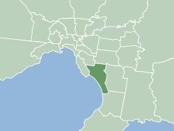
Mentone is a suburb in Melbourne, Victoria, Australia, 21 km south-east of Melbourne's Central Business District, located within the City of Kingston local government area. Mentone recorded a population of 13,197 at the 2021 census.
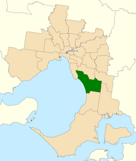
The Division of Isaacs is an Australian Electoral Division in the state of Victoria. It is located in the south-eastern suburbs of Melbourne, on the eastern shores of Port Phillip Bay. It covers the suburbs of Mordialloc, Keysborough (part), Waterways, Cheltenham (part), Dingley Village, Chelsea, Aspendale, Aspendale Gardens, Edithvale, Bonbeach, Patterson Lakes, Carrum, Parkdale, Mentone, Dandenong South, Highett, Heatherton and Moorabbin.

The electoral district of Dandenong is an electoral district of the Victorian Legislative Assembly. It was first proclaimed in 1904 when the district of Dandenong and Berwick was abolished.
Electoral district of Moorabbin was an electoral district of the Legislative Assembly in the Australian state of Victoria.
Electoral district of Heatherton was an electoral district of the Legislative Assembly in the Australian state of Victoria.
The electoral district of Springvale was an electoral district of the Legislative Assembly in the Australian state of Victoria. It was replaced in 2002, by the electoral districts of Lyndhurst and Mulgrave.
Electoral district of Pakenham is an electoral district of the Legislative Assembly in the Australian state of Victoria. It was recreated in the redistribution of electoral boundaries in 2021, and will be re-contested at the 2022 Victorian state election.
Electoral district of Dandenong North was an electoral district of the Legislative Assembly in the Australian state of Victoria.
Electoral district of Doveton was an electoral district of the Legislative Assembly in the Australian state of Victoria.
Electoral district of Noble Park was an electoral district of the Legislative Assembly in the Australian state of Victoria.
Electoral district of Reservoir was an electoral district of the Legislative Assembly in the Australian state of Victoria.
Electoral district of Syndal was an electoral district of the Legislative Assembly in the Australian state of Victoria.

The Shire of Broadford was a local government area about 70 kilometres (43 mi) north of Melbourne, the state capital of Victoria, Australia. The shire covered an area of 576.3 square kilometres (222.5 sq mi), and existed from 1869 until 1994.

The City of Mordialloc was a local government area about 20 kilometres (12 mi) south of Melbourne, the state capital of Victoria, Australia, on the eastern side of Port Phillip. The city covered an area of 13.57 square kilometres (5.24 sq mi), and existed from 1920 until 1994.

The City of Moorabbin was a local government area about 20 kilometres (12 mi) southeast of Melbourne, the state capital of Victoria, Australia. The city covered an area of 53.13 square kilometres (20.51 sq mi), and existed from 1862 until 1994.
The electoral district of Nunawading was an electoral district of the Legislative Assembly in the Australian state of Victoria, located in the eastern Melbourne suburb of Nunawading. A notable former member was future Prime Minister, Robert Menzies.
Hampden was an electoral district of the Legislative Assembly in the Australian state of Victoria from 1904 until its abolition in 1976. Most of the territory located in the old division of Hampden was transferred into the re-created electorate of Ripon. Hampden's most notable member was the longest serving Premier of Victoria Sir Henry Bolte. The seat was a marginally conservative seat, having never been won by the non-conservative parties for more than one term.
Karamus is a neighbourhood in the Silvan District of Diyarbakır Province in Turkey.

The Bay Trail is a shared use path for cyclists and pedestrians which follows the coastline of Port Phillip Bay through the south-eastern suburbs of Melbourne, Victoria, Australia.
References
- ↑ "Re-Member (Former Members)". State Government of Victoria. Retrieved 11 May 2013.