The Victorian Legislative Assembly is the lower house of the bicameral Parliament of Victoria in Australia; the upper house being the Victorian Legislative Council. Both houses sit at Parliament House in Spring Street, Melbourne.
The Victorian Legislative Council (VLC) is the upper house of the bicameral Parliament of Victoria, Australia, the lower house being the Legislative Assembly. Both houses sit at Parliament House in Spring Street, Melbourne. The Legislative Council serves as a house of review, in a similar fashion to its federal counterpart, the Australian Senate. Although, it is possible for legislation to be first introduced in the Council, most bills receive their first hearing in the Legislative Assembly.
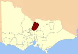
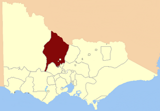
Ballarat East was an electoral district of the Legislative Assembly in the Australian state of Victoria. Prior to its abolition, it was a 3,323 km² part-urban and part-rural electorate covering areas to the east of the regional centre of Ballarat. It included the Ballarat suburbs of Ballarat East, Bakery Hill, Golden Point, Eureka, Canadian, Mount Pleasant, Mount Clear, Mount Helen and Warrenheip, and the rural towns of Ballan, Buninyong, Bungaree, Creswick, Daylesford, Dunnstown, Hepburn Springs, Kyneton, Lal Lal, Malmsbury, Meredith and Steiglitz. The electorate had a population of 54,127 as of the 2006 census, with 40,578 enrolled electors at the 2010 state election.
The 2002 Victorian state election, held on Saturday, 30 November 2002, was for the 55th Parliament of Victoria. It was held to elect the 88 members of Victorian Legislative Assembly and 22 members of the 44-member Legislative Council.

MacKillop is a single-member electoral district for the South Australian House of Assembly. It was named in 1991 after Sister Mary MacKillop who served the local area, and later became the first Australian to be canonised as a Roman Catholic saint. MacKillop is a 25,313 km² rural electorate in the south-east of the state, stretching south and west from the mouth of the Murray River to the Victorian State border, but excluding the far-southern point of the state,. It contains the Kingston District Council, Naracoorte Lucindale Council, District Council of Robe, Tatiara District Council, Wattle Range Council, as well as parts of The Coorong District Council. The main population centres are Bordertown, Keith, Kingston SE, Meningie, Millicent, Naracoorte, Penola and Robe.

Richmond is an electoral district of the Legislative Assembly in the Australian state of Victoria. It is currently a 13 km² electorate in the inner east of Melbourne, encompassing the suburbs of Richmond, Cremorne, Burnley, Abbotsford, Collingwood, Clifton Hill, North Fitzroy and Fitzroy. Historically a very safe seat for the Labor Party, Richmond has in recent elections become increasingly marginal against the Greens, who narrowly failed to win it at the 2014 Victorian state election.

The 1996 Victorian state election, held on Saturday, 30 March 1996, was for the 53rd Parliament of Victoria. It was held in the Australian state of Victoria to elect all 88 members of the state's Legislative Assembly and 22 members of the 44-member Legislative Council. The election took place four weeks after the 1996 federal election which swept the Labor Party from power nationally.
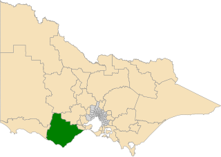
The electoral district of Polwarth is an electoral district of the Victorian Legislative Assembly. It is located in south-west rural Victoria, west of Geelong, and covers the Colac and Corangamite local government areas (LGA), parts of the Moyne, Golden Plains and Surf Coast LGAs, and slivers of the Ararat and Greater Geelong LGAs, running along the Great Ocean Road taking in Anglesea, Cape Otway, Peterborough, Aireys Inlet, Lorne, Wye River, Apollo Bay and Port Campbell, covering the inland towns of Winchelsea, Colac, Camperdown and Terang along the Princes Highway, and Inverleigh, Cressy, Lismore and Mortlake on the Hamilton Highway, and finally, includes the Otway Ranges and Lake Corangamite.

The electoral district of Warrandyte is an Australian electoral district of the Victorian Legislative Assembly. It is an outer metropolitan electorate and contains the suburbs of Park Orchards, Ringwood North, Warrandyte, Warrandyte North, Warrandyte South, Warranwood, Wonga Park, most of Donvale, and parts of Chirnside Park, Doncaster East, and Ringwood.

The electoral district of Melbourne is an electorate of the Victorian Legislative Assembly. It currently includes the localities of Docklands, Carlton, Melbourne, East Melbourne, West Melbourne, North Melbourne, Parkville, Newmarket, Kensington and Flemington, and includes Melbourne University. The district has been in existence since 1856.
The Electoral district of Swan Hill was a rural Lower House electoral district of the Victorian Parliament. It was located within the Northern Victoria Region of the Legislative Council.

The 2010 Victorian state election, held on Saturday, 27 November 2010, was for the 57th Parliament of Victoria. The election was to elect all 88 members of the Legislative Assembly and all 40 members of the Legislative Council. The incumbent centre-left Labor Party government, led by John Brumby, was defeated by the centre-right Liberal/National Coalition opposition, led by Ted Baillieu. The election gave the Coalition a one-seat majority in both houses of parliament.
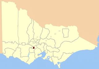
Port Melbourne was an electoral district of the Victorian Legislative Assembly. It was created in 1889, replacing the previous electorate of Sandridge, which was the former name for Port Melbourne.

The 2014 Victorian state election, held on Saturday, 29 November 2014, was for the 58th Parliament of Victoria. All 88 seats in the Victorian Legislative Assembly and 40 seats in the Victorian Legislative Council were up for election. The incumbent centre-right Coalition minority government, led by Liberal Party leader and Premier Denis Napthine and National Party leader and Deputy Premier Peter Ryan, was defeated by the centre-left Labor Party opposition, led by Daniel Andrews. The Greens won two lower house seats, their first Legislative Assembly seats in a Victorian state election, whilst increasing their share of upper house seats. The new Andrews Ministry was sworn in on 4 December 2014.

Members of the Victorian Legislative Council, the upper house of the Parliament of the Australian State of Victoria, are elected from eight multi-member electorates called regions. The Legislative Council has 40 members, five from each of the eight regions.
Loddon was an electoral district of the Legislative Assembly in the Australian state of Victoria from 1856 to 1859. It was based in northern Victoria around the Loddon River.

The Murray was an electoral district of the Legislative Assembly in the Australian colony of Victoria from 1856 to 1877.

Murray Boroughs was an electoral district of the Legislative Assembly in the Australian state of Victoria from 1856 to 1877. It was based in northern Victoria, and included the towns of Benalla Avenel Euroa Seymour, Wodonga and Wangaratta. The district of Murray Boroughs was one of the initial districts of the first Victorian Legislative Assembly, 1856.

The electoral district of Murray Plains is an electoral district of the Victorian Legislative Assembly in Australia. It was created in the redistribution of electoral boundaries in 2013, and came into effect at the 2014 state election.
This is a list of candidates for the 2014 Victorian state election. The election was held on 29 November 2014.