South Melbourne Victoria—Legislative Assembly | |
---|---|
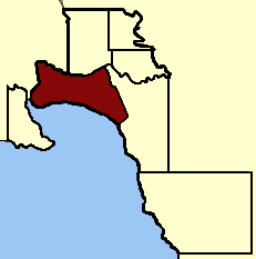
![]() Location in Victoria | |
State | Victoria |
Created | 1856 |
Abolished | 1859 |
Demographic | Metropolitan |
Electoral district of South Melbourne was an electoral district of the Legislative Assembly [1] in the British colony of Victoria (Australia).
Its area was defined by the Victoria Constitution Act as: "Bounded on the North by the Yarra Yarra River, from its Junction with the Saltwater River to Princes’ Bridge, on the East by the Road bearing Southeast to the Northern Angle of Section No. 46, St. Kilda, thence by Fitz Roy Street to the Sea Coast, thence by the Sea Coast to the Yarra Yarra River, and by the said River to its Junction with the Saltwater River, being the commencing Point." [2]
South Melbourne was abolished by the Victorian Electoral Act, 1858. [3] New districts of Emerald Hill and Sandridge were created. [3]
Member | Party | Term | |
---|---|---|---|
Sir Andrew Clarke [4] | Unaligned | Nov. 1856 – Aug. 1858 [r] | |
Robert Anderson | Unaligned | Oct. 1858 [b] – Aug. 1859 |
b = by-election
r = resigned [1]
The electoral district of Melbourne is an electorate of the Victorian Legislative Assembly. It currently includes the localities of Docklands, Carlton, Melbourne, East Melbourne, West Melbourne, North Melbourne, Parkville, Newmarket, Kensington and Flemington, and includes Melbourne University. The district has been in existence since 1856.
The Electoral district of St Kilda was one of the inaugural electoral districts of the Victorian Legislative Assembly, abolished on 2 October 1992.
Port Melbourne was an electoral district of the Victorian Legislative Assembly. It was created in 1889, replacing the previous electorate of Sandridge, which was the former name for Port Melbourne.
Sandridge was an electoral district of the Victorian Legislative Assembly. It existed from 1859 until 1889, when it was abolished and replaced with Port Melbourne, reflecting the name change of the suburb at its centre. Frederick Derham, the last member for the seat, continued as member for Port Melbourne.
Melbourne West Province was an electorate of the Victorian Legislative Council from 1904 until 2006.
The Electoral district of Maldon was an electoral district of the Victorian Legislative Assembly.
The Electoral district of Alberton was an electoral district of the Legislative Assembly in the Australian colony of Victoria, located in the south-east of the then-colony.
The Electoral district of Maryborough was an electorate of the Victorian Legislative Assembly based on an area around Maryborough, Victoria. It was created in the expansion of the Assembly by the Victorian Electoral Act, 1858, which took effect at the election in 1859.
Emerald Hill was an electoral district of the Victorian Legislative Assembly, Australia. It covered part of the inner-city suburb South Melbourne and consisted part of the previous Electoral district of South Melbourne which was abolished in 1859..
South Yarra Province was an electorate of the Victorian Legislative Council from November 1882 until May 1904.
Central Province was an electorate of the Victorian Legislative Council.
Collingwood was an electoral district of the Legislative Assembly in the Australian state of Victoria from 1856 to 1958. It centred on the Melbourne suburb of Collingwood, Victoria.
West Bourke was an electoral district of the Legislative Assembly in the Australian state of Victoria from 1856 to 1904.
East Bourke Boroughs was an electoral district of the Legislative Assembly in the Australian state of Victoria from 1859 to 1904.
East Melbourne was an electoral district of the Legislative Assembly in the Australian state of Victoria from 1859 to 1927.
Loddon was an electoral district of the Legislative Assembly in the Australian state of Victoria from 1856 to 1859. It was based in northern Victoria around the Loddon River.
Ovens was an electoral district of the Legislative Assembly in the Australian state of Victoria from 1856 to 1927. It was based in northern Victoria, bordered by the Ovens River in the south-west and included the town of Beechworth, Victoria.
Dalhousie was an electoral district of the Legislative Assembly in the Australian state of Victoria from 1859 to 1927. It was based in north-western Victoria. The district had been named Electoral district of Anglesey. The district of Dalhousie was defined in the 1858 Electoral Act as :
THE ELECTORAL DISTRICT OF DALHOUSIE.
ANGLESEY. Bounded on the west by part of the eastern boundary of the County of Dalhousie, namely, by the River Goulburn from the confluence of Hughes's Creek to the confluence of Dabyminga Creek; thence by Dabyminga Creek to its source in the Great Dividing Range; on the south by the Great Dividing Range to the main source of the River Goulburn; on the east by the range dividing the waters of the main source of the Goulburn and Big Rivers from those of the Rubicon and Snod-por-dock Creek northward to Mount Torbrick; thence by Jerusalem Creek to its confluence with the River Goulburn; thence by the River Goulburn to the confluence of the River Delatite; thence by the River Delatite and its north-west arm to the Dividing Range between the last named arm and Septimus Creek; and on the north by that range to the source of Hughes's Creek; and thence by Hughes's Creek to its confluence with the River Goulburn, excepting the country included in the Boroughs of Seymour and Avenel ... DALHOUSIE. Commencing at the junction of the Rivers Campaspe and Coliban; thence by a line south-easterly to the source of the Mclvor or Patterson's Creek; thence by a line north-east to the confluence of Hughes's Creek with the River Goulburn; on the east by the River Goulburn until it joins the Dabyminga Creek, by that creek to its source in the Dividing Range; on
the south by the Dividing Range to the source of the River Coliban; and on the west by the last mentioned river to its junction with the River Campaspe, being the commencing point, excepting the country included in the electoral districts of the Kyneton Boroughs, Murray Boroughs, and Kilmore.
Jolimont and West Richmond was an electoral district of the Legislative Assembly in the Australian state of Victoria from 1889 to 1904. It was located in the inner eastern suburbs of Melbourne and included parts of Richmond and Jolimont.
Melbourne South was an electoral district of the Legislative Assembly in the Australian state of Victoria from 1889 to 1904.
37°50′S144°57′E / 37.833°S 144.950°E