Related Research Articles
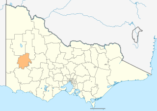
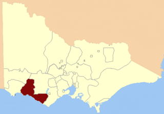
The Rural City of Horsham is a local government area in Victoria, Australia, located in the western part of the state. It covers an area of 4,267 square kilometres (1,647 sq mi) and in June 2018, had a population of 19,875. It includes the towns of Brimpaen, Dadswells Bridge, Dooen, Haven, Horsham, Laharum, Natimuk, Noradjuha and Pimpinio. It was formed in 1995 by the amalgamation of the City of Horsham, most of the Shire of Wimmera and Shire of Arapiles, and part of the Shire of Kowree.
The Division of Mallee is an Australian Electoral Division in the state of Victoria. It is located in the far north-west of the state, adjoining the border with South Australia in the west, and the Murray River in the north. At 81,962 square kilometres (31,646 sq mi), it is the largest Division in Victoria. It includes the centres of Mildura, Ouyen, Swan Hill, St Arnaud, Warracknabeal, Stawell, Horsham and Maryborough.

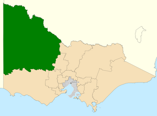
The electoral district of Lowan is a rural Victorian Legislative Assembly electoral district of the Victorian Parliament. It is located within the Western Victoria Region of the Legislative Council. It was initially created by the Electoral Act Amendment Act 1888, taking effect at the 1889 elections. It is the state’s biggest electorate by area, covering about 41,858 km².
Electoral district of Reservoir was an electoral district of the Legislative Assembly in the Australian state of Victoria.
The Electoral district of Kara Kara and Borung was an electoral district of the Victorian Legislative Assembly.

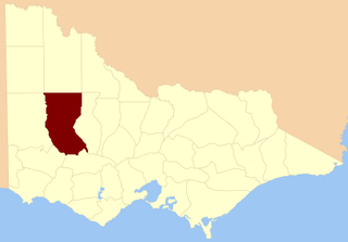
The Shire of Dunmunkle was a local government area about 160 kilometres (99 mi) west of Bendigo and 50 kilometres (31 mi) east of Horsham, in western Victoria, Australia. The shire was bounded by the Yarriambiack Creek on the western boundary and the Richardson River on the east. The shire covered an area of 1,550 square kilometres (598.5 sq mi), and existed from 1877 until 1995.

The Shire of Warracknabeal was a local government area about 200 kilometres (124 mi) west-northwest of Bendigo and 60 kilometres (37 mi) north of Horsham, in western Victoria, Australia. The shire covered an area of 1,839 square kilometres (710.0 sq mi), and existed from 1891 until 1995.

The Shire of Wimmera was a local government area in the Wimmera region of western Victoria, Australia. The municipality covered an area of 2,611 square kilometres (1,008.1 sq mi), and existed from 1862 until 1995. Although its shire offices were located in Horsham, Horsham itself was governed by a separate council after it succeeded in 1882.

The electoral district of Wimmera was an electoral district of the Legislative Assembly in the Australian state of Victoria.
The Electoral district of Maryborough and Talbot was an electorate of the Victorian Legislative Assembly from 1877.
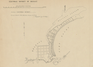
The electoral district of Belfast was an electorate of the Victorian Legislative Assembly in the British colony of Victoria. It was one of the original lower house seats in the first Parliament of Victoria in 1856. Belfast was renamed in 1889 to Port Fairy after the town of Belfast was also renamed.

The Electoral district of South Bourke was an electoral district of the Legislative Assembly in then Australian colony of Victoria. It was one of the original 36 electoral districts of the Assembly. It covered an area east of Melbourne, bounded by Dandenong Creek in the south and east, Moorabbin, Prahran and Hawthorn in the west and Templestowe in the north. It was abolished in 1889.
The electoral district of Borung was an electorate of the Victorian Legislative Assembly in the Australian colony of Victoria, which existed in two incarnations, from 1889 to 1927, and then from 1945 to 1955.
Villiers and Heytesbury was an electoral district of the Legislative Assembly in the Australian state of Victoria from 1856 to 1904. It was based in western Victoria, and included the area from Lake Corangamite along the coast westward past Port Fairy.

Port Fairy was an electoral district of the Legislative Assembly in the Australian state of Victoria from 1889 to 1927. It was created when the Electoral district of Belfast was renamed. Bryan O'Loghlen was the last member for Belfast, serving 1888–1889.

Ovens was an electoral district of the Legislative Assembly in the Australian state of Victoria from 1856 to 1927. It was based in northern Victoria, bordered by the Ovens River in the south-west and included the town of Beechworth, Victoria.
Wangaratta and Rutherglen was an electoral district of the Legislative Assembly in the Australian state of Victoria from 1889 to 1904. It was located around the towns of Wangaratta and Rutherglen. When it was abolished in 1904, the new Electoral district of Wangaratta was created; John Bowser was the last member for Wangaratta and Rutherglen and the first for Wangaratta.
The Electoral district of Belfast and Warrnambool was one of the original sixteen electoral districts of the unicameral Legislative Council of the British colony of Victoria in 1851 to 1856.
This is a list of members of the Victorian Legislative Assembly, from the elections of 28 March 1889 to the elections of 20 April 1892. There were 95 seats in the Assembly from 1889, up from 86 in the previous Parliament.
This is a list of members of the Victorian Legislative Assembly, from the 1902 state election held on 1 October 1902 to the 1904 state election held on 1 June 1904. From 1889 there were 95 seats in the Assembly.
References
- 1 2 3 4 "Re-Member (Former Members)". State Government of Victoria. Retrieved 26 November 2012.
- ↑ "Victorian General Election". The Queenslander. 30 March 1889. Retrieved 26 November 2012.
36°43′S142°12′E / 36.717°S 142.200°E
| | This Victoria (Australia) government-related article is a stub. You can help Wikipedia by expanding it. |