
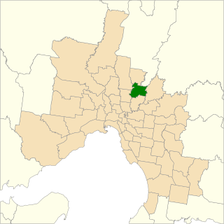
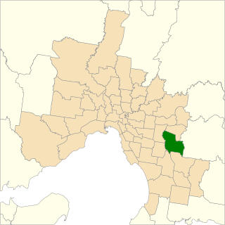
The electoral district of Box Hill is an electoral district of the Victorian Legislative Assembly, covering an area of 29 square kilometres (11 sq mi) in eastern Melbourne. It contains the suburbs of Box Hill, Box Hill North, Box Hill South, Mont Albert, Mont Albert North, most of Blackburn, Blackburn North, and Blackburn South, and parts of Balwyn North, Burwood, Burwood East, and Surrey Hills.

The electoral district of Dandenong is an electoral district of the Victorian Legislative Assembly. It was first proclaimed in 1904 when the district of Dandenong and Berwick was abolished.

The electoral district of Mount Waverley was an electoral district of the Victorian Legislative Assembly. It was located in the south-eastern suburbs of Melbourne and contained the suburbs of Glen Waverley and Mount Waverley.
Bundoora is an electoral district of the Victorian Legislative Assembly. It covers an area of 35 square kilometres (14 sq mi) in north-eastern Melbourne, encompassing the suburbs of Bundoora, Kingsbury, Watsonia and Watsonia North, and parts of Greensborough, Macleod, Mill Park and Yallambie. It also includes the central campus of La Trobe University. It lies within the North-Eastern Metropolitan Region of the upper house, the Legislative Council.

The electoral district of St Albans is an electoral district of the Victorian Legislative Assembly. It has existed in 2 incarnations, first from 1985 to 1992, and was created again in the 2013 redistribution and came into effect at the 2014 state election.
Electoral district of Pakenham is an electoral district of the Legislative Assembly in the Australian state of Victoria. It was recreated in the redistribution of electoral boundaries in 2021, and was re-contested at the 2022 Victorian state election.

The electoral district of Berwick is an electoral district of the Legislative Assembly in the Australian state of Victoria.
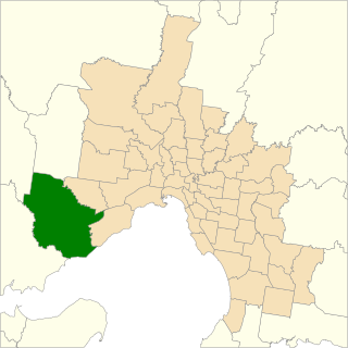
The electoral district of Werribee is an electoral district of the Legislative Assembly in the Australian state of Victoria. It has existed in two incarnations, first from 1976 to 2002, and was created again in the 2013 redistribution and came into effect at the 2014 state election.
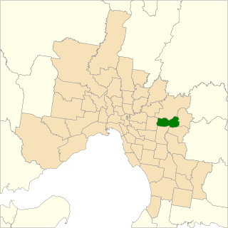
The electoral district of Ringwood is an electoral district of the Victorian Legislative Assembly, located in the east of Melbourne. It was first proclaimed in 1958 and was abolished in 1992. Some of Ringwood was included in the new electoral district of Bayswater that year. Kay Setches, who was at the time the last member for Ringwood, contested and lost Bayswater at the 1992 election.

The electoral district of Wendouree is an electoral district of the Victorian Legislative Assembly in Australia. It was created in the redistribution of electoral boundaries in 2013, and came into effect at the 2014 state election.

The electoral district of Buninyong was an electoral district of the Victorian Legislative Assembly in Australia. It was created in the redistribution of electoral boundaries in 2013, and came into effect at the 2014 state election.

The electoral district of Clarinda is an electoral district of the Victorian Legislative Assembly in Australia. It was created for the 2014 state election and is represented by Meng Heang Tak for the Labor Party.

The electoral district of Croydon is an electoral district of the Victorian Legislative Assembly, located in the east of Melbourne. It was created in the redistribution of electoral boundaries in 2013, and came into effect at the 2014 state election.

The electoral district of Eildon is an electoral district of the Victorian Legislative Assembly in Australia. It was created in the redistribution of electoral boundaries in 2013, which came into effect at the 2014 state election and is a member of the Northern Victoria Region.

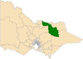
The electoral district of Euroa is an electoral district of the Victorian Legislative Assembly in Australia. It was created in the redistribution of electoral boundaries in 2013.
The electoral district of Ovens Valley is an electoral district of the Victorian Legislative Assembly in Australia. It was created in the redistribution of electoral boundaries in 2013, and came into effect at the 2014 state election.
The electoral district of Rowville is an electoral district of the Victorian Legislative Assembly in Australia. It was created in the redistribution of electoral boundaries in 2013, and came into effect at the 2014 state election.
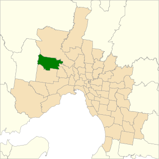
The electoral district of Sydenham is an electoral district of the Victorian Legislative Assembly in Australia. It was created in the redistribution of electoral boundaries in 2013, and came into effect at the 2014 state election.

The Electoral district of Eureka is an electoral district of the Victorian Legislative Assembly in Australia. It was created in the redistribution of electoral boundaries in 2021, and came into effect at the 2022 Victorian state election.

The Electoral district of Point Cook is an electoral district of the Victorian Legislative Assembly in Australia. It was created in the redistribution of electoral boundaries in 2021, and came into effect at the 2022 Victorian state election.
