Waurn Ponds Geelong, Victoria | |||||||||||||||
---|---|---|---|---|---|---|---|---|---|---|---|---|---|---|---|
![]() View of the suburb south from Rossack Drive | |||||||||||||||
![]() | |||||||||||||||
Coordinates | 38°13′S144°17′E / 38.217°S 144.283°E | ||||||||||||||
Population | 5,046 (2016 census) [1] | ||||||||||||||
Postcode(s) | 3216 | ||||||||||||||
LGA(s) | City of Greater Geelong | ||||||||||||||
State electorate(s) | South Barwon | ||||||||||||||
Federal division(s) | Corangamite | ||||||||||||||
|
Waurn Ponds is a mainly residential southern suburb of Geelong, Victoria, Australia.
The suburb is bounded by Rossack Drive, Princes Highway, the Geelong to Warrnambool railway, Reservoir Road, Draytons Road, Pigdons Road, Deakin University and Honeys Road. It is home to the main Geelong campus of Deakin University and the regional Waurn Ponds Shopping Centre. There are many schools around Waurn Ponds like Mount Duneed Regional Primary School.
The town was named after the Waurn chain of ponds, a watercourse that flows from Mount Moriac over 30 km into the Barwon River. [2]
'Waurn' meaning "place of many houses" in reference to aboriginal stone houses in the Wathaurong language, though there is no evidence of this outside of Mr Pascoes book. [3]
It is thought that the name derives from an Aboriginal word meaning camp, although another authority states that the original name was Warren's Chain of Ponds. [4]
Two early hotels – the Victoria Inn (1845–60) and the Waurn Ponds Inn (1856) were located on the Princes Highway serving travellers on the road. The Albert and Victoria vineyards, owned by David Pettavel, began growing grapes in 1848 and the area was better known as Pettavel in the 1860s. [5] The Pettavel Post Office opened on 12 January 1865 and remained open until 1952. The Waurn Ponds Post Office opened on 1 December 1871 and closed in 1968. [6]
A quarry for limestone was opened in the 1840s, with quarrying continuing from 1964 to today at the nearby Blue Circle Southern cement works. [7] Kilns for making mortar lime operated until the 1970s. [5]
The Waurn Ponds Memorial Reserve (Formally Waurn Ponds Avenue of Honour) is located on the Corner of Cochranes Road and Waurn Ponds Drive, Waurn Ponds. The Avenue of Honour was planted in July 1919, by the residents of Waurn Ponds as a tribute to the Waurn Ponds World War One Servicemen.
In 1999, the Victorian State Government decided to sell the Avenue of Honour. Local residents and the Victorian RSL President Bruce Ruxton campaigned that the Avenue of Honour would not be auctioned and that the site be protected. The Victorian State Government overturned the sale of the Waurn Ponds Memorial Reserve and a Committee of Management was appointed with Mr Jack Harriott been the Chair.
A re dedication service was held with a plaque listing the Waurn Ponds W.W.1 Servicemen unveiled. In 2000, another two plaques were added with additional Waurn Ponds Servicemen who served in World War One and another plaque honouring the Waurn Ponds Servicemen and Servicewomen who served in the Second World War.
Today there are plaques acknowledging those that served in the Korean War, Vietnam War, Royal Australian Air Force Nurses and Servicewomen from the Geelong area. The Memorial Reserve is also home to the 3.7 Anti Aircraft Gun which is on display at the Reserve. An annual memorial service is held on the first Sunday of July to mark the anniversary of the Waurn Ponds Memorial Reserve. [8] [9] [10]
The Waurn Ponds Hall which is located on 225 Waurn Ponds Drive was erected in 1924 as mechanics institute and free library. The Hall is now used for many local events and can be hired for private functions. The back of the Waurn Ponds Hall was the original Waurn Ponds State School which was relocated to Grovedale Primary School and later back to the Waurn Ponds Hall as an extension. [11] [12]
Waurn Ponds started to become part of the outer suburbs of Geelong from the 1970s, with the opening of the Deakin University campus and the Waurn Ponds Hotel on the highway. Major development did not begin until the early 1990s, based around Ghazeepore Road. The intervening years have seen housing developments spread across the hillside towards Grovedale.
Waurn Ponds contains a number of heritage listed sites, including:
Waurn Ponds is home to the quite small Waurn Ponds Creek. It starts around the Mount Moriac region and eventually flows into the Barwon River near Belmont Common. [2]
As of 2007, it is low on water and is no more than one metre deep in most sections. It has a large weed problem which makes the creek look uninhabitable. The creek is home to species of fish (many introduced) including Carp, Redfin, Roach, Tench, Australian Grayling and short finned eels. The creek also is a large habitat of native birds including the pacific black duck. Increase in annual rain will bring the creek back to its original status.
The Friends of the Waurn Ponds Creek is a community group that gather on the first and third Sunday of the month to protect and conserve the health of the Waurn Ponds Creek and surrounding area. The Friends first started in 2002 and have won awards for their dedication and work towards enhancing the creek to protect the native fish and wildlife that habitat are along the creek. The Friends plant trees, clean up rubbish and maintain weeds and tree planting sites.
Waurn Ponds has a large linear parkland following the creek. The neighbouring suburb of Grovedale has a skate park and baseball complex.
Waurn Ponds has a Hall, Tennis Club, Cricket Club and Memorial Reserve to the west of Waurn Ponds.
The Waurn Ponds Tennis Club located on 20 Belperroud Road off Waurn Ponds Drive, is a successful tennis club which has junior and senior competitions in the Tennis Geelong Competition.
The Waurn Ponds Cricket Club located on Waurn Ponds Drive, access from Deskin University was established in 1986 and currently has senior men's team and junior sides. The Club is in the Geelong Cricket Association.
The boundaries of Waurn Ponds were expanded in 2012 when, as a result of boundary changes related to the development of the nearby Armstrong Creek Growth Area, an area of land in the west of the current suburb between the Princes Highway and the Geelong-Warrnambool railway line was shifted from the locality of Mount Duneed to Waurn Ponds. [15] [16] [17] [18]
Waurn Ponds is located on the Princes Highway that links the suburb with the centre of Geelong. It is also the southern endpoint of the Geelong Ring Road, completed in 2009. Anglesea Road heads south through the suburb, linking the area to Torquay and Anglesea. Pioneer Road links the region west to Grovedale, the road not being completed eastward across the Waurn Ponds Creek until the mid-1990s. [19]
Public transport to the area is provided by buses operated by CDC Geelong and McHarry's Buslines, under contract to Public Transport Victoria. Routes to the Geelong city centre originate and terminate at Deakin University.
The Geelong V/Line rail service, to and from Geelong and Melbourne, was extended to the new Waurn Ponds railway station, situated in Sugargum Drive, in 2014. [20] The new station was named Grovedale in the planning stages, despite being physically located in Waurn Ponds, [21] but the official name of Waurn Ponds was announced in July 2014. [22]
An earlier extension of Geelong line rail services in the direction of Waurn Ponds had been considered when funding was set aside for a new station beyond South Geelong station in 2003–04, but that eventually resulted in the new station being built at Marshall, closer to Geelong, instead. [23]
The Deakin University campus at Waurn Ponds had the beginnings in the Gordon Institute of TAFE, who purchased land there in 1969. A building for the Applied Sciences was first built, followed by a library and student lodgings in 1975. [24] In 1976 the Gordon Institute was divided into two parts, with academic courses becoming part of the newly formed Deakin University based at the Waurn Ponds campus.
Deakin enrolled its first students at its Waurn Ponds campus in 1977. Today the university is located on a 365-hectare (900-acre) site, has over 1,000 staff and over 4000 on-campus students. [25]
Deakin offers many social groups for students to join, The main Association is DUSA, followed closely by the Deakin Students' Commerce Society Deakin University Student Association#Deakin Commerce Students' Society
The Waurn Ponds Shopping Centre, located on the corner of Colac Road (Princes Highway) and Pioneer Road, is a regional-level shopping centre servicing the southern suburbs of Geelong and the surrounding region. It was opened in the early 1990s, and has been continually expanded. The most recent expansion was completed in August 2014, and increased the total area of the centre to 47,000 square metres. There are over 160 different shops.
The Geelong Homemaker Centre, located on the Colac Road (Princes Highway) at the intersection and Pigdons Road, opened in mid-2005. It includes Bunnings Warehouse and Harvey Norman stores, as well as a number of smaller stores, such as Supercheap Auto, Beacon Lighting, Snooze, Ray's Outdoors and, most recently, JB-Hi-Fi.
Waurn Ponds Plaza, located at the intersection of Rossack Drive and the Colac Road (Princes Highway), is another shopping centre in Waurn Ponds. It is the location of the office of the federal member for Corangamite, Libby Coker.
Geelong is a port city in Victoria, Australia, located at the eastern end of Corio Bay and the left bank of Barwon River, about 75 km (47 mi) southwest of Melbourne. With an estimated population of 282,809 in 2023, Geelong is the second largest city in the state of Victoria. It is the administrative centre for the City of Greater Geelong municipality, which is Port Phillip's only regional metropolitan area, and covers all the urban, rural and coastal reserves around the city including the entire Bellarine Peninsula and running from the plains of Lara in the north to the rolling hills of Waurn Ponds to the south, with Corio Bay to the east and the Barrabool Hills to the west.
Princes Highway is a major road in Australia, extending from Sydney via Melbourne to Adelaide through the states of New South Wales, Victoria and South Australia. It has a length of 1,941 kilometres (1,206 mi) or 1,898 kilometres (1,179 mi) via the former alignments of the highway, although these routes are slower and connections to the bypassed sections of the original route are poor in many cases.
Burwood is an inner eastern suburb of Melbourne, Victoria, Australia, 14 kilometres east of Melbourne's Central Business District, located within the Cities of Monash and Whitehorse local government areas. Burwood recorded a population of 15,147 at the 2021 census.
Princes Freeway is a 159-kilometre (99 mi) Australian freeway, divided into two sections, both located in Victoria, Australia. The freeway links Melbourne to Geelong in the west, and to Morwell in the east. It continues beyond these extremities as the Princes Highway towards Adelaide to the west and Sydney to the northeast. The freeway bears the designation M1.
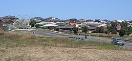
Grovedale is a southern suburb of Geelong, Victoria, Australia. At the 2021 census, Grovedale had a population of 14,869.
Highton is a residential suburb of Geelong, Victoria, Australia. With views across Geelong, Corio Bay and the surrounding region, Highton is located along the banks of the Barwon River and across the rolling Barrabool Hills. The Barwon River straddles Highton to the north and east, while it is bordered by the hilly Ceres and Wandana Heights to the west, the former Kardinia Creek separates the suburb from Belmont to the south-east, and the Princes Highway and Pigdons Road to the south separate the suburb from Waurn Ponds.
Belmont is a southern suburb of Geelong, Victoria, Australia. The name means "beautiful hill". Belmont is geographically separated from the Geelong central business district by the Barwon River. The suburb is primarily residential, with some light industry along Barwon Heads Road. The suburb is part of the City of Greater Geelong local government area. At the 2011 census, Belmont had a population of 13,616.
Geelong railway station is a regional railway station on the Warrnambool line, which is part of the Regional railway network. It serves the city Geelong, in Victoria, Australia. Geelong station is a ground-level unstaffed station, featuring three platforms, an island platform with two faces and one side platform. It opened on 1 November 1856.
South Geelong railway station is a regional railway station on the Warrnambool line, which is part of the Regional railway network. It serves the southern Geelong suburb of South Geelong, in Victoria, Australia. South Geelong station is a ground level premium station, featuring two side platforms, connected by an accessible footbridge and concourse. It opened on 1 November 1883, with the current station provided in 2024.
North Geelong railway station is a regional railway station on the Warrnambool line, which is part of the Regional railway network. It serves the northern Geelong suburb of North Geelong, in Victoria, Australia. North Geelong station is a ground-level unstaffed station, featuring two side platforms. It opened on 1 August 1883, with the current station provided in 1990.
North Shore railway station is a regional railway station on the Warrnambool line, which is part of the Regional railway network. It serves the northern Geelong suburbs of North Shore and Norlane, in Victoria, Australia. North Shore station is a ground-level unstaffed station, featuring two side platforms. It opened on 15 April 1895, with the current station provided in 1991.
Lara railway station is located on the Warrnambool line in Victoria, Australia. It serves the town of Lara, and it opened on 1 November 1856 as Duck Ponds. It was renamed Lara on 30 June 1875.
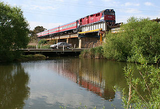
The Warrnambool line is a long-distance regional rail service in Victoria, Australia. Operated by V/Line, it is the state's fourth longest railway line at 267.3 kilometres (166.1 mi). The line runs from Southern Cross station in central Melbourne to Warrnambool station in the south-west, serving 21 stations via Wyndham Vale, Geelong, Waurn Ponds, and Colac. The line has five return services each weekday and three return services on weekends. Trains on the Warrnambool service run with three- to five-car N-class carriage sets, which are hauled by N class locomotives.
Marshall railway station is a regional railway station on the Warrnambool line, which is part of the Regional railway network. It serves the southern Geelong suburb of Marshall, in Victoria, Australia. Marshall station is a ground level premium station, featuring two side platforms, connected by an accessible footbridge and concourse. It opened on 14 July 1879, with the current station provided in 2024. It initially closed on 14 October 1957, then reopened on 26 April 2005.
Waurn Ponds Shopping Centre is a major regional shopping centre servicing the southern suburbs of the city of Geelong, Victoria, Australia. It is located on the corner of Colac and Pioneer Roads in the suburb of Grovedale.
The Warrnambool railway line is a railway serving the south west of Victoria, Australia. Running from the western Melbourne suburb of Newport through the cities of Geelong and Warrnambool, the line once terminated at the coastal town of Port Fairy before being truncated to Dennington. This closed section of line has been converted into the 37 km long Port Fairy to Warrnambool Rail Trail. The line continues to see both passenger and freight services today.
Waurn Ponds railway station is located on the Warrnambool line in Victoria, Australia. It serves the southern Geelong suburb of the same name, and opened on 12 October 2014.
Surfcoast Highway is a semi-rural highway in Victoria, Australia, connecting the city of Geelong with the coastal town of Torquay. The highway runs through the Armstrong Creek Growth Area, which is the subject of extensive residential development; closer to Torquay, tourist attractions the Narana Creations indigenous centre, Surf Coast Plaza retail centre, and the Surfworld museum are located along the highway.
Freshwater Creek is a small rural community in the Surf Coast Shire, Victoria, Australia. In the 2016 census, Freshwater Creek had a population of 414 people.
Grovedale was a railway station on the outskirts of Geelong, located on the Warrnambool railway line in Victoria, Australia. Located near the current Torquay Road level crossing, the station opened in 1876 as Germantown and was renamed Grovedale in February 1916.
{{cite book}}
: CS1 maint: multiple names: authors list (link) CS1 maint: numeric names: authors list (link)