
Geelong is a port city in Victoria, Australia, located at the eastern end of Corio Bay and the left bank of Barwon River, about 75 km (47 mi) southwest of Melbourne. With an estimated population of 282,809 in 2023, Geelong is the second largest city in the state of Victoria. It is the administrative centre for the City of Greater Geelong municipality, which is Port Phillip's only regional metropolitan area, and covers all the urban, rural and coastal reserves around the city including the entire Bellarine Peninsula and running from the plains of Lara in the north to the rolling hills of Waurn Ponds to the south, with Corio Bay to the east and the Barrabool Hills to the west.

The City of Greater Geelong is a local government area in the Barwon South West region of Victoria, Australia, located in the western part of the state. It covers an area of 1,248 square kilometres (482 sq mi) and, had a population of 271,057 as of the 2021 Australian census. It is primarily urban with the vast majority of its population living in the Greater Geelong urban area, while other significant settlements within the LGA include Anakie, Balliang, Barwon Heads, Batesford, Ceres, Clifton Springs, Drysdale, Lara, Ocean Grove, Portarlington and St Leonards. It was formed in 1993 from the amalgamation of the Rural City of Bellarine, Shire of Corio, City of Geelong, City of Geelong West, City of Newtown, City of South Barwon, and parts of Shire of Barrabool and Shire of Bannockburn.

Grovedale is a southern suburb of Geelong, Victoria, Australia. At the 2021 census, Grovedale had a population of 14,869.
Lovely Banks is a northern suburb of Geelong, Victoria, Australia. Once an agricultural and rural area, the suburb is quickly developing into a residential area adjoining the Geelong suburbs of Bell Park, Corio and Norlane. At the 2016 census Lovely Banks had a population of 2,301.

Little River is a town in Victoria, Australia, approximately 44 kilometres (27 mi) south-west of Melbourne's Central Business District, located within the Cities of Greater Geelong and Wyndham local government areas. Little River recorded a population of 1,353 at the 2021 census.
Fyansford is a township on the western edge of Geelong, Victoria, Australia, named after Captain Foster Fyans who came to Geelong as a Police magistrate in October, 1837. It is located at the junction of the Barwon and Moorabool rivers. At the 2016 census, Fyansford had a population of 196.

Norlane is a northern suburb of Geelong, in Victoria, Australia. Norlane is bordered in the south by Cowies Creek, in the north by Cox Road, in the west by Thompson Road and in the east by Station Street. It is about 7 km from the Geelong central business district and approximately 70 km from the state capital, Melbourne. It is about one kilometre from the shore of Corio Bay. At the 2016 census, Norlane had a population of 8,306.

Clifton Springs is a coastal town located on the Bellarine Peninsula, near Geelong, Victoria, Australia.
Drumcondra is a wealthy residential bayside suburb of Geelong, Victoria, Australia, overlooking Corio Bay. It is the smallest suburb in Geelong and one of the smallest in Victoria. It was named after Drumcondra, which is an inner suburb of Dublin, Ireland. At the 2016 census, Drumcondra had a population of 560.
Newtown is an inner western suburb of Geelong, Victoria, Australia. At the 2021 census, Newtown had a population of 10,445. It is a primarily residential area occupying one of the highest points of urban Geelong. It has always been a desirable place of residence and is the location of many of Geelong's oldest and most valuable properties.

Hamlyn Heights is a residential suburb of Geelong. It located to the west of the city on hills that overlook Corio Bay.
Bannockburn is a town near Geelong, Victoria, Australia, 88 km southwest of Melbourne. It is located in Golden Plains Shire. In the 2021 census, Bannockburn had a population of 6,470.

Winchelsea is a town in Victoria, Australia. The town is located in the Surf Coast Shire local government area, the suburb or locality of Winchelsea is predominantly within Surf Coast Shire with a small section within the Colac Otway Shire. Winchelsea is located on the Barwon River 115 km south-west of Melbourne and close to Geelong.

North Shore railway station is a regional railway station on the Warrnambool line, part of the Victorian railway network. It serves the northern suburb of North Shore, in Geelong Victoria, Australia. North Shore station is a ground-level unstaffed station, featuring three platforms, a standard gauge side platform at Platform 3 and V/Line railway services on island platform at Platforms 1 and 2. It opened on 15 April 1895, with the current station provided in 1991.

Meredith is a town in Victoria, Australia, located on the Midland Highway between Ballarat and Geelong, in the local government area of the Golden Plains Shire. At the 2021 census, Meredith had a population of 821, an increase from the 788 at the 2016 census

The City of Geelong was a local government area about 75 kilometres (47 mi) southwest of Melbourne, the state capital of Victoria, Australia. The city covered an area of 13.4 square kilometres (5.2 sq mi), and existed from 1849 until 1993.
The City of Geelong West was a local government area about 5 kilometres (3 mi) west of the regional city of Geelong, Victoria, Australia. The city covered an area of 5.26 square kilometres (2.0 sq mi), and existed from 1875 until 1993.
The City of Newtown was a local government area about 3 kilometres (1.9 mi) west of the regional city of Geelong, Victoria, Australia. The city covered an area of 6.22 square kilometres (2.4 sq mi), and existed from 1858 until 1993.

The Shire of Corio was a local government area located between Geelong and Werribee, about 60 kilometres (37 mi) southwest of Melbourne, the state capital of Victoria, Australia. The shire, which included all of Geelong's northern suburbs, covered an area of 704.66 square kilometres (272.1 sq mi), and existed from 1861 until 1993.
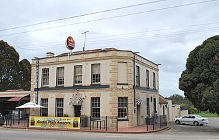
Edward Prowse was an architect working in the Geelong region of Victoria, Australia in the late nineteenth century. He was responsible for many early Geelong buildings, including hotels, mansions and churches.


