
Geelong is a port city in Victoria, Australia, located at the eastern end of Corio Bay and the left bank of Barwon River, about 65 km (40 mi) southwest of Melbourne.

Princes Highway is a major road in Australia, extending from Sydney via Melbourne to Adelaide through the states of New South Wales, Victoria and South Australia. It has a length of 1,941 kilometres (1,206 mi) or 1,898 kilometres (1,179 mi) via the former alignments of the highway, although these routes are slower and connections to the bypassed sections of the original route are poor in many cases.

Bells Beach is a coastal locality of Victoria, Australia in Surf Coast Shire and a renowned surf beach, located 100 km south-west of Melbourne, on the Great Ocean Road near the towns of Torquay and Jan Juc.

Torquay is a seaside resort in Victoria, Australia, which faces Bass Strait, 21 km south of Geelong and is the gateway to the Great Ocean Road. It is bordered on the west by Spring Creek and its coastal features include Point Danger and Zeally Bay. At the 2021 census, Torquay had a population of 18,534.

Melway, colloquially referred to as Melways or The Melways, is a street directory for Melbourne, Victoria, Australia and its immediate surrounds, including the city of Geelong. Formerly a highly ubiquitous directory, Melway is currently in its 50th edition—the 2024 edition.

Grovedale is a southern suburb of Geelong, Victoria, Australia. At the 2021 census, Grovedale had a population of 14,869.
Waurn Ponds is a mainly residential southern suburb of Geelong, Victoria, Australia.

Winchelsea is a town in Victoria, Australia. The town is located in the Surf Coast Shire local government area, the suburb or locality of Winchelsea is predominantly within Surf Coast Shire with a small section within the Colac Otway Shire. Winchelsea is located on the Barwon River 115 km south-west of Melbourne and close to Geelong.
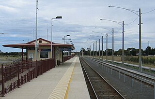
Marshall, formerly known as Marshalltown, is a residential suburb of Geelong, Victoria, Australia. At the 2021 census, Marshall had a population of 2,299. The Marshall railway station is located in the suburb.

Inverleigh is a town in Victoria, Australia located 28 kilometres (17 mi) west from the City of Geelong and 87 kilometres (54 mi) from the state capital, Melbourne. The town is divided between Golden Plains Shire and Surf Coast Shire. In the 2021 census, the central area of Inverleigh had a population of 1,746. Inverleigh is known to be a popular stopover destination on the way to Lorne. The Inverleigh Hotel is very popular attracting customers from Geelong.
Connewarre is a locality in Victoria, Australia, is located in the City of Greater Geelong and Surf Coast Shire, and is named after Lake Connewarre which is situated immediately to its north-east. Connewarre is a version of "kunuwarra", the name of the black swan in the Wathawurrung language. At the 2016 census, Connewarre and the surrounding area had a population of 788.

Breamlea, Victoria, Australia, is a secluded seaside hamlet located on the south coast of the Bellarine Peninsula, 18 kilometres south of Geelong, and halfway between Barwon Heads and Torquay. It is divided between the City of Greater Geelong and the Surf Coast Shire. In the 2016 census, Breamlea had a permanent population of 162.
The City of South Barwon was a local government area in Victoria, Australia, which contained a number of Geelong suburbs south of the Barwon River, and extending to Torquay in the south and Barwon Heads to the east. The city covered an area of 165.4 square kilometres (63.9 sq mi), and existed from 1863 until 1994.
The Armstrong Creek Growth Area is a southern extension to the urban growth boundary of the metropolitan area of Geelong, Victoria, Australia. It comprises parts of the localities of Grovedale and Marshall south of the Warrnambool railway line, and parts of the localities of Mount Duneed and Connewarre from some distance to the north of Lower Duneed Road and generally to the west of Barwon Heads Road.
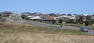
Armstrong Creek is a suburb of Geelong, Victoria, Australia. It was gazetted in February 2012 as part of the Armstrong Creek Growth Area, and was mostly farm land which had been part of Connewarre and Mount Duneed. At the 2021 census, Armstrong Creek had a population of 11,247.
Charlemont is a suburb of Geelong, Victoria, Australia. At the 2021 census, Charlemont had a population of 2,612, growing from 364 taken at the 2016 census. It was gazetted in February 2012 as part of the Armstrong Creek Growth Area, from largely undeveloped land which had formerly been part of Grovedale and Marshall.
Surfcoast Highway is a semi-rural highway in Victoria, Australia, connecting the city of Geelong with the coastal town of Torquay. The highway runs through the Armstrong Creek Growth Area, which is the subject of extensive residential development; closer to Torquay, tourist attractions the Narana Creations indigenous centre, Surf Coast Plaza retail centre, and the Surfworld museum are located along the highway.
Mount Moriac is a rural locality in the Surf Coast Shire, Victoria, Australia. In the 2016 census, Mount Moriac had a population of 240 people.
Freshwater Creek is a small rural community in the Surf Coast Shire, Victoria, Australia. In the 2016 census, Freshwater Creek had a population of 414 people.
In 29 June 1861, the 1-acre (0.40 ha) Duneed Aboriginal Land Reserve was set aside for the Wadawurrung (Wathaurong) people. The reserve was located on Ghazeepore Road just south of Armstrong Creek, in Mount Duneed, Victoria, Australia.


