Related Research Articles

Geelong is a port city in Victoria, Australia, located at the eastern end of Corio Bay and the left bank of Barwon River, about 75 km (47 mi) southwest of Melbourne. With an estimated population of 282,809 in 2023, Geelong is the second largest city in the state of Victoria. It is the administrative centre for the City of Greater Geelong municipality, which is Port Phillip's only regional metropolitan area, and covers all the urban, rural and coastal reserves around the city including the entire Bellarine Peninsula and running from the plains of Lara in the north to the rolling hills of Waurn Ponds to the south, with Corio Bay to the east and the Barrabool Hills to the west.

The City of Greater Geelong is a local government area in the Barwon South West region of Victoria, Australia, located in the western part of the state. It covers an area of 1,248 square kilometres (482 sq mi) and, had a population of 271,057 as of the 2021 Australian census. It is primarily urban with the vast majority of its population living in the Greater Geelong urban area, while other significant settlements within the LGA include Anakie, Balliang, Barwon Heads, Batesford, Ceres, Clifton Springs, Drysdale, Lara, Ocean Grove, Portarlington and St Leonards. It was formed in 1993 from the amalgamation of the Rural City of Bellarine, Shire of Corio, City of Geelong, City of Geelong West, City of Newtown, City of South Barwon, and parts of Shire of Barrabool and Shire of Bannockburn.

Princes Freeway is a 159-kilometre (99 mi) Australian freeway, divided into two sections, both located in Victoria, Australia. The freeway links Melbourne to Geelong in the west, and to Morwell in the east. It continues beyond these extremities as the Princes Highway towards Adelaide to the west and Sydney to the northeast. The freeway bears the designation M1.

Grovedale is a southern suburb of Geelong, Victoria, Australia. At the 2021 census, Grovedale had a population of 14,869.
Waurn Ponds is a mainly residential southern suburb of Geelong, Victoria, Australia.
Highton is a residential suburb of Geelong, Victoria, Australia. With views across Geelong, Corio Bay and the surrounding region, Highton is located along the banks of the Barwon River and across the rolling Barrabool Hills. The Barwon River straddles Highton to the north and east, while it is bordered by the hilly Ceres and Wandana Heights to the west, the former Kardinia Creek separates the suburb from Belmont to the south-east, and the Princes Highway and Pigdons Road to the south separate the suburb from Waurn Ponds.

Belmont is a southern suburb of Geelong, Victoria, Australia. The name means "beautiful hill". Belmont is geographically separated from the Geelong central business district by the Barwon River. The suburb is primarily residential, with some light industry along Barwon Heads Road. The suburb is part of the City of Greater Geelong local government area. At the 2011 census, Belmont had a population of 13,616.

The Geelong line is a regional passenger rail service operated by V/Line in Victoria, Australia. It serves 15 stations towards its terminus in Waurn Ponds, a southern suburb of Geelong, via the Regional Rail Link. It is the most used regional rail service in Victoria, carrying 8.15 million people in the 2022-23 financial year.

Geelong railway station is a regional railway station on the Warrnambool line, part of the Victorian railway network. It serves the city Geelong, in Victoria, Australia. Geelong station is a ground-level unstaffed station, featuring three platforms, an island platform with two faces and one side platform. It opened on 1 November 1856.

North Shore railway station is a regional railway station on the Warrnambool line, part of the Victorian railway network. It serves the northern suburb of North Shore, in Geelong Victoria, Australia. North Shore station is a ground-level unstaffed station, featuring three platforms, a standard gauge side platform at Platform 3 and V/Line railway services on island platform at Platforms 1 and 2. It opened on 15 April 1895, with the current station provided in 1991.
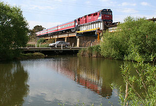
The Warrnambool line is a long-distance regional rail service in Victoria, Australia. Operated by V/Line, it is the state's fourth longest railway line at 267.3 kilometres (166.1 mi). The line runs from Southern Cross station in central Melbourne to Warrnambool station in the south-west, serving 21 stations via Wyndham Vale, Geelong, Waurn Ponds, and Colac. The line has five return services each weekday and three return services on weekends. Trains on the Warrnambool service run with three- to five-car N-class carriage sets, which are hauled by N class locomotives.

Marshall railway station is a regional railway station on the Warrnambool line, part of the Victorian railway network. It serves the southern suburb of Marshall, in Geelong, Victoria, Australia. Marshall station is a ground level premium station, featuring two side platforms, connected by an accessible footbridge and concourse. It opened on 14 July 1879 and was rebuilt in 2024 as part of the Regional Rail Revival project. The station was initially closed on 14 October 1957, then reopened on 26 April 2005.
Mount Duneed is a suburb of Geelong, Victoria, Australia. It is divided between the City of Greater Geelong and Surf Coast Shire local government areas. Mount Duneed itself is an extinct volcano and the remains of the crater can be seen in the Mount Duneed Recreation Reserve.
Connewarre is a locality in Victoria, Australia, is located in the City of Greater Geelong and Surf Coast Shire, and is named after Lake Connewarre which is situated immediately to its north-east. Connewarre is a version of "kunuwarra", the name of the black swan in the Wathawurrung language. At the 2016 census, Connewarre and the surrounding area had a population of 788.

Waurn Ponds Shopping Centre is a major regional shopping centre servicing the southern suburbs of the city of Geelong, Victoria, Australia. It is located on the corner of Colac and Pioneer Roads in the suburb of Grovedale.

Christian College is a K–12 private school located over six campuses in Geelong, Victoria, Australia.
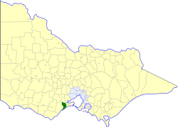
The Shire of Barrabool was a local government area about 100 kilometres (62 mi) southwest of Melbourne, the state capital of Victoria, Australia. The shire covered an area of 575.18 square kilometres (222.1 sq mi), and existed from 1853 until 1994.
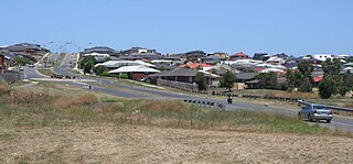
Armstrong Creek is a suburb of Geelong, Victoria, Australia. It was gazetted in February 2012 as part of the Armstrong Creek Growth Area, and was mostly farm land which had been part of Connewarre and Mount Duneed. At the 2021 census, Armstrong Creek had a population of 11,247.

Waurn Ponds railway station is a regional railway station on the Warrnambool line, part of the Victorian railway network. It serves the southern Geelong suburb of Waurn Ponds, in Victoria, Australia. Waurn Ponds station is a ground level premium station, featuring two side platforms. It opened on 12 October 2014, with the current station provided in 2022.
Surfcoast Highway is a semi-rural highway in Victoria, Australia, connecting the city of Geelong with the coastal town of Torquay. The highway runs through the Armstrong Creek Growth Area, which is the subject of extensive residential development; closer to Torquay, tourist attractions the Narana Creations indigenous centre, Surf Coast Plaza retail centre, and the Surfworld museum are located along the highway.
References
- ↑ "The Armstrongs". Stephanie Kihlstrom. Retrieved 11 August 2010.
- ↑ "Armstrong Creek Urban Growth Plan Volume 1" (PDF). City of Greater Geelong. Retrieved 22 June 2012.
- ↑ Kyle Pollard (4 June 2010). "Let Armstrong Creek building begin". Geelong Advertiser. Retrieved 11 August 2010.
- ↑ "About Armstrong Creek". City of Greater Geelong. Retrieved 14 May 2012.
- ↑ "Buses come later". Geelong Advertiser. 4 August 2011. Retrieved 14 May 2012.
- ↑ "New bus service for Armstrong Creek". Public Transport Victoria. Retrieved 31 December 2019.
- ↑ "Suite of projects in growth area - City of Greater Geelong". www.geelongaustralia.com.au. Retrieved 29 July 2019.
