Murrumbeena is a suburb in Melbourne, Victoria, Australia, 13 km south-east of Melbourne's Central Business District, located within the City of Glen Eira local government area. Murrumbeena recorded a population of 9,996 at the 2021 census.

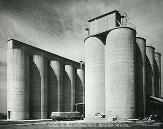
Herne Hill is a residential suburb of Geelong, Victoria, Australia. At the 2016 census, Herne Hill had a population of 3,413. It is in the federal Division of Corio, and its postcode is 3218.

Hamlyn Heights is a residential suburb of Geelong. It located to the west of the city on hills that overlook Corio Bay.

South Geelong, also referred to as Geelong South, is a southern suburb of Geelong, Victoria, Australia. Its local government area is the City of Greater Geelong. At the 2016 census, South Geelong had a population of 993.
Tittybong is a locality in the northwest of Victoria, Australia, within the Shires of Gannawarra and Buloke. Tittybong is located west of Kerang and east of the Calder Highway. It is south of Swan Hill, Tittybong's nearest large town. At the 2016 census, Tittybong had a population of 3.

Wollert is a suburb in Melbourne, Victoria, Australia, 26 km north of Melbourne's central business district, located within the City of Whittlesea local government area. Wollert recorded a population of 24,407 at the 2021 census.

Inkerman is a rural town and locality in the Shire of Burdekin, Queensland, Australia. In the 2021 census, the locality of Inkerman had a population of 119 people.

Ivanhoe is a suburb of Melbourne, Victoria, Australia, 9 kilometres (5.6 mi) north-east of Melbourne's Central Business District, located within the City of Banyule local government area. Ivanhoe recorded a population of 13,374 at the 2021 census.
Mannerim is a semi-rural locality on the Bellarine Peninsula of Victoria, Australia.

Piangil, once frequently spelled "Pyangil", is a town in the Mallee region of northern Victoria, Australia. It is approximately 382 kilometres (237 mi) north west of the state capital, Melbourne and 46 kilometres (29 mi) north west of the regional centre of Swan Hill. At the 2016 census, Piangil and the surrounding rural area had a population of 259.
Clare is a rural town and locality in the Shire of Burdekin, Queensland, Australia. In the 2021 census, the locality of Clare had a population of 201 people.

Pilton is a rural town and locality in the Toowoomba Region, Queensland, Australia. It is south of the city of Toowoomba. In the 2021 census, the locality of Pilton had a population of 71 people.

Branxholme is a township in the Shire of Southern Grampians in the Western District of Victoria, Australia on the Henty Highway between Heywood and Hamilton. At the 2016 census, Branxholme and the surrounding area had a population of 351.
Waitchie is a locality in Victoria, Australia, located approximately 44 km (27 mi) from Swan Hill, Victoria. At the 2006 census, Waitchie had a population of 118, decreasing to 48 at the 2016 census.
Nowie is a locality in Victoria, Australia, located approximately 26 km from Swan Hill, Victoria.
Tresco is a locality in Victoria, Australia, located approximately 23 km from Swan Hill. It was named after Tresco, Isles of Scilly, England. At the 2016 census, Tresco had a population of 209.

Raglan is a town in western Victoria, Australia. It is located 177 kilometres (110 mi) north west of the state capital, Melbourne in the Shire of Pyrenees local government area. At the 2021 census, Raglan had a population of 223.

Jimbour East is a rural locality in the Western Downs Region, Queensland, Australia. The town of Jimbour in the locality. In the 2021 census, Jimbour East had a population of 197 people.
Kentville is a rural locality in the Lockyer Valley Region, Queensland, Australia. In the 2021 census, Kentville had a population of 108 people.
Nevilton is a rural locality in the Toowoomba Region, Queensland, Australia. In the 2021 census, Nevilton had a population of 25 people.


