
Geelong is a port city in Victoria, Australia, located at the eastern end of Corio Bay and the left bank of Barwon River, about 75 km (47 mi) southwest of Melbourne. With an estimated population of 282,809 in 2023, Geelong is the second largest city in the state of Victoria. It is the administrative centre for the City of Greater Geelong municipality, which is Port Phillip's only regional metropolitan area, and covers all the urban, rural and coastal reserves around the city including the entire Bellarine Peninsula and running from the plains of Lara in the north to the rolling hills of Waurn Ponds to the south, with Corio Bay to the east and the Barrabool Hills to the west.

The City of Greater Geelong is a local government area in the Barwon South West region of Victoria, Australia, located in the western part of the state. It covers an area of 1,248 square kilometres (482 sq mi) and, had a population of 271,057 as of the 2021 Australian census. It is primarily urban with the vast majority of its population living in the Greater Geelong urban area, while other significant settlements within the LGA include Anakie, Balliang, Barwon Heads, Batesford, Ceres, Clifton Springs, Drysdale, Lara, Ocean Grove, Portarlington and St Leonards. It was formed in 1993 from the amalgamation of the Rural City of Bellarine, Shire of Corio, City of Geelong, City of Geelong West, City of Newtown, City of South Barwon, and parts of Shire of Barrabool and Shire of Bannockburn.

The Barwon River is a perennial river of the Corangamite catchment, located in The Otways and the Bellarine Peninsula regions of the Australian state of Victoria.
Hamilton Highway is a rural highway through the Barwon South West region of Victoria, Australia, linking Geelong and the town of Hamilton.
Breakwater is a residential and industrial suburb of Geelong, Victoria, Australia, located on the Barwon River, 4 km south-south-east of the Geelong central business district. At the 2016 census Breakwater had a population of 1,014. Breakwater is home to the Geelong Racing Club, Geelong Racecourse and the Geelong Showgrounds.
Newtown is an inner western suburb of Geelong, Victoria, Australia. At the 2021 census, Newtown had a population of 10,445. It is a primarily residential area occupying one of the highest points of urban Geelong. It has always been a desirable place of residence and is the location of many of Geelong's oldest and most valuable properties.

Bell Post Hill is a residential suburb of Geelong, Victoria, Australia. At the 2016 census, Bell Post had a population of 4,919.

Belmont is a southern suburb of Geelong, Victoria, Australia. The name means "beautiful hill". Belmont is geographically separated from the Geelong central business district by the Barwon River. The suburb is primarily residential, with some light industry along Barwon Heads Road. The suburb is part of the City of Greater Geelong local government area. At the 2011 census, Belmont had a population of 13,616.

Barwon Heads is a coastal township on the Bellarine Peninsula, near Geelong, Victoria, Australia. It is situated on the west bank of the mouth of the Barwon River below Lake Connewarre, and is bounded to the west by farmland, golf courses and the saline ephemeral wetland of Murtnaghurt Lagoon. At the 2021 census, Barwon Heads had a population of 4,353.

Winchelsea is a town in Victoria, Australia. The town is located in the Surf Coast Shire local government area, the suburb or locality of Winchelsea is predominantly within Surf Coast Shire with a small section within the Colac Otway Shire. Winchelsea is located on the Barwon River 115 km south-west of Melbourne and close to Geelong.

The Geelong Ring Road is a freeway ring road in Australia beside Geelong's western suburbs from the Princes Freeway at Corio to the Princes Highway at Waurn Ponds. It also connects to the Midland Highway towards Ballarat, and the Hamilton Highway.

The Moorabool River is a river in Victoria, Australia, which runs for 160 kilometres through several small towns such as Meredith, Anakie, and Staughton Vale. It runs into the Barwon River at Fyansford. It is believed that the name Moorabool derives from an Aboriginal word meaning the cry of a curlew or a ghost.

Foster Fyans was an Irish military officer, penal colony administrator and public servant. He was acting commandant of the second convict settlement at Norfolk Island, the commandant of the Moreton Bay penal settlement at Brisbane, the first police magistrate at Geelong, and commissioner of crown lands for the Portland Bay pastoral district in the Port Phillip District of New South Wales. He is the great-great-grandfather of actor Sam Neill.
Batesford is a town located approximately 10 kilometres west of Geelong and 67 kilometres south-west of the state capital, Melbourne.
The Geelong Racecourse is a major regional horse racing venue in Geelong, Victoria, Australia. The current racecourse dates to 1908. The annual Geelong Cup is held at the course every October, as well as a number of other race meets through the year.
Edward Giles Stone was an Australian engineer prominent in many innovative, often daringly spectacular, aspects of early reinforced concrete constructions in Australia. He was also involved in cement manufacture. He was briefly a pioneer in prefab housing but that industry was destined to use timber, not concrete plates.

Moorabool is a locality of the City of Greater Geelong local government area in Victoria, Australia.
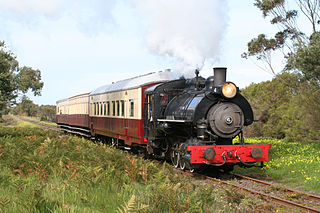
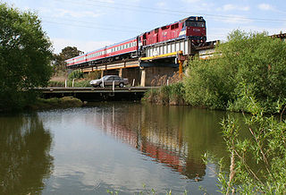
The Fyansford Cement Works Railway was an industrial railway near Geelong, Australia, built by the Australian Portland Cement Company to carry limestone from its quarry to its cement works at Fyansford.
Edward Prowse was an architect working in the Geelong region of Victoria, Australia in the late nineteenth century. He was responsible for many early Geelong buildings, including hotels, mansions and churches.

The Barwon Sewer Aqueduct is a heritage-listed aqueduct across the Barwon River at Goat Island, Breakwater, Victoria, Australia. It was designed by engineer E. G. Stone and was erected between 1913-1915. It would appear to be the only one of its kind in Australia in terms of its length and the use of Considère's construction technique. The aqueduct appears to be the last example in Australia of Armand Considère's system of reinforcing for concrete structures. It was added to the Victorian Heritage Register on 23 October 1991.


