Geelong is a port city in the southeastern Australian state of Victoria, located at the eastern end of Corio Bay and the left bank of Barwon River, about 65 km (40 mi) southwest of Melbourne, the state capital of Victoria.

Melbourne Airport, colloquially known as Tullamarine Airport, is the primary airport serving the city of Melbourne, and the second busiest airport in Australia. It opened in 1970 to replace the nearby Essendon Airport. Melbourne Airport is the main international airport of the four airports serving the Melbourne metropolitan area, the other international airport being Avalon Airport.
Jetstar Airways Pty Ltd, operating as Jetstar, is an Australian low-cost airline headquartered in Melbourne. It is a wholly owned subsidiary of Qantas, created in response to the threat posed by airline Virgin Blue. Jetstar is part of Qantas' two brand strategy of having Qantas Airways for the premium full-service market and Jetstar for the low-cost market. Jetstar carries 8.5% of all passengers travelling in and out of Australia.

Gold Coast Airport is an international Australian airport located at the southern end of the Gold Coast and approximately 90 km (56 mi) south of centre of Brisbane, within South East Queensland agglomeration. The entrance to the airport is situated in the suburb of Bilinga near Coolangatta. The runway itself cuts through the state borders of Queensland and New South Wales. During summer, these states are in two different time zones. The Gold Coast Airport operates on Queensland Time all year round.

Geelong Airport was a small airfield specifically for light aircraft located in Mount Duneed, Victoria, Australia. It was primarily used for scenic flights and private aircraft, and was located in the local government area of the City of Greater Geelong.

Avalon Airport is an international airport located in Avalon in the City of Greater Geelong in Victoria, Australia. While located outside the Melbourne metropolitan area, it is the second busiest of the four airports serving the state capital in passenger traffic. It is located 15 km (9 mi) north-east of the Geelong CBD and 50 kilometres (31 mi) south-west of the Melbourne CBD. The airport is operated by Avalon Airport Australia Pty Ltd, a subsidiary of Linfox.
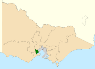
The Division of Corio is an Australian electoral division in the state of Victoria. The division was proclaimed in 1900, and was one of the original 65 divisions to be contested at the first federal election. Named for Corio Bay, it has always been based on the city of Geelong, although in the past it stretched as far east as the outer western suburbs of Melbourne.
Corio is a residential and industrial area, which forms one of the largest suburbs of Geelong, Victoria in Australia. It is located approximately 9 km north of the Geelong central business district. The area was formerly known as Cowie's Creek after James Cowie, an early land owner who was active in the local and state government.
Lara is a town in Victoria, 18 km north-east of the Geelong CBD, inland from the Princes Freeway to Melbourne. Its population at the 2016 census was 16,355.

Norlane is a northern suburb of Geelong, in Victoria, Australia. Norlane is bordered in the south by Cowies Creek, in the north by Cox Road, in the west by Thompson Road and in the east by Station Street. It is about 7 km from the Geelong central business district and approximately 70 km from the state capital, Melbourne. It is about one kilometre from the shore of Corio Bay. At the 2016 census, Norlane had a population of 8,306.

Rippleside is a suburb of Geelong, Victoria, Australia. The suburb overlooks Corio Bay. At the 2016 census, Rippleside had a population of 875.

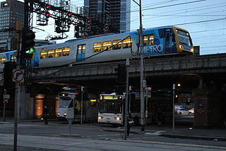
The Geelong line is a regional passenger rail service operated by V/Line in Victoria, Australia. It serves passengers between state capital Melbourne and the regional city of Geelong.
Transport in Melbourne, the state capital of Victoria, Australia, consists of several interlinking modes. Melbourne is a hub for intercity, intracity and regional travel. Road-based transport accounts for most trips across many parts of the city, facilitated by Australia's largest freeway network. Public transport, including the world's largest tram network, trains and buses, also forms a key part of the transport system. Other dominant modes include walking, cycling and commercial-passenger vehicle services such as taxis.

The City of Geelong was a local government area about 75 kilometres (47 mi) southwest of Melbourne, the state capital of Victoria, Australia. The city covered an area of 13.4 square kilometres (5.2 sq mi), and existed from 1849 until 1993.

Victoria is a state in southeastern Australia. It is the second-smallest state with a land area of 227,444 km2 (87,817 sq mi), the second most populated state with a population of over 6.6 million, and the most densely populated state in Australia. Victoria is bordered by New South Wales to the north and South Australia to the west, and is bounded by the Bass Strait to the south, the Great Australian Bight portion of the Southern Ocean to the southwest, and the Tasman Sea to the southeast. The state encompasses a range of climates and geographical features from its temperate coastal and central regions to the Victorian Alps in the northeast and the semi-arid north-west.

Tiger Airways Australia Pty Ltd, operating as Tigerair Australia, was an Australian low-cost airline. Founded by Tiger Airways Holdings, it commenced services in the domestic airline market on 23 November 2007 as Tiger Airways Australia. It later became a subsidiary of Virgin Australia Holdings. On 25 March 2020, Tigerair suspended all operations as a result of the COVID-19 pandemic. Following Virgin Australian Holdings going into voluntary administration and later sold, new owner Bain Capital confirmed the brand would be retired.

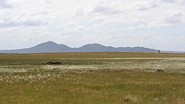
Point Wilson is a locality located on the northern shores of Corio Bay, Victoria. it is approximately 60 kilometres by road from Melbourne, and 25 kilometres by road from Geelong.

Victoria is the southernmost mainland state of Australia. With an area of 227,594 km2 (87,875 sq mi), it is Australia's sixth largest state/territory, comparable in size to the island of Great Britain or the U.S. state of Utah. It is bound to the northwest by South Australia, directly north by New South Wales, and also shares a maritime border with Tasmania across the Bass Strait to the south. Most of Victoria's northern border lies along the Murray River. The eastern half of the state is dominated by the Australian Alps and the surrounding highlands of the Great Dividing Range, which also to a lesser extent extend far into the west of the state and ease off after The Grampians. By comparison the north and northwest of the state is extremely flat with little prominence.
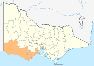
The Barwon South West is an economic rural region located in the southwestern part of Victoria, Australia. The Barwon South West region stretches from the tip of the Queenscliff Heads to the border of South Australia. It is home to Victoria’s largest provincial centre, Geelong and the major centres of Aireys Inlet, Apollo Bay, Camperdown, Colac, Hamilton, Lorne, Port Campbell, Port Fairy, Portland, Torquay and Warrnambool. It draws its name from the Barwon River and the geographic location of the region in the state of Victoria.