
Geelong is a port city located on Corio Bay and the Barwon River, in the state of Victoria, Australia. The traditional owners of the land on which Geelong sits are the Wadawurrung people of the Kulin nation.

The Division of Corio is an Australian electoral division in the state of Victoria. The division was proclaimed in 1900, and was one of the original 65 divisions to be contested at the first federal election. Named for Corio Bay, it has always been based on the city of Geelong, although in the past it stretched as far east as the outer western suburbs of Melbourne.
Lovely Banks is a northern suburb of Geelong, Victoria, Australia. Once an agricultural and rural area, the suburb is quickly developing into a residential area adjoining the Geelong suburbs of Bell Park, Corio and Norlane. At the 2016 Census Lovely Banks had a population of 2,301.
Fyansford is a township on the western edge of Geelong, Victoria, Australia, named after Captain Foster Fyans who came to Geelong as a Police magistrate in October, 1837. It is located at the junction of the Barwon and Moorabool rivers. At the 2016 Census, Fyansford had a population of 196.

Norlane is a northern suburb of Geelong, in Victoria, Australia. Norlane is bordered in the south by Cowies Creek, in the north by Cox Road, in the west by Thompson Road and in the east by Station Street. It is about 7 km from the Geelong central business district and approximately 70 km from the state capital, Melbourne. It is about one kilometre from the shore of Corio Bay. At the 2016 Census, Norlane had a population of 8,306.
Bell Park is a residential suburb of Geelong, Victoria, Australia. It is located 3 km north-west of the Geelong city centre and is bordered to the north by the Ballarat rail line, to the east by Thompson Road, to the south by the Midland Highway and to the west by Anakie Road.
Highton is a residential suburb of Geelong, Victoria, Australia. With views across Geelong, Corio Bay and the surrounding region, Highton is located along the banks of the Barwon River and across the rolling Barrabool Hills. The Barwon River straddles Highton to the north and east, while it is bordered by the hilly Ceres and Wandana Heights to the west, the former Kardinia Creek separates the suburb from Belmont to the south-east, and the Princes Highway and Pigdons Road to the south separate the suburb from Waurn Ponds.

Bell Post Hill is a residential suburb of Geelong, Victoria, Australia. At the 2016 Census, Bell Post had a population of 4,919.

Belmont is a southern suburb of Geelong, Victoria, Australia. The name means "beautiful hill". Belmont is geographically separated from the Geelong central business district by the Barwon River. The suburb is primarily residential, with some light industry along Barwon Heads Road. The suburb is part of the City of Greater Geelong local government area. At the 2011 census, Belmont had a population of 13,616.
Herne Hill is a residential suburb of Geelong, Victoria, Australia. At the 2016 Census, Herne Hill had a population of 3,413. It is in the federal Division of Corio, and its postcode is 3218.

South Geelong, also referred to as Geelong South, is a southern suburb of Geelong, Victoria, Australia. Its local government area is the City of Greater Geelong. At the 2016 Census, South Geelong had a population of 993.
Bacchus Marsh is an urban centre and suburban locality in Victoria, Australia located approximately 50 kilometres (30 mi) north west of the state capital Melbourne and 14 kilometres (9 mi) west of Melton at a near equidistance to the major cities of Melbourne, Ballarat and Geelong. The population of the Bacchus Marsh urban area was 22,223 at June 2018. Bacchus Marsh is the largest urban area in the local government area of Shire of Moorabool.

The Geelong Ring Road is a freeway ring road in Australia that extends for 27 km (17 mi) beside Geelong's western suburbs from the Princes Freeway at Corio to the Princes Highway at Waurn Ponds. It also connects to the Midland Highway towards Ballarat, and the Hamilton Highway. Sections one and two were officially opened 14 December 2008, with section three on 14 June 2009. Section four opened in January 2013 extending to the Princes Highway at Mount Moriac, which now avoids the narrow and windy road from Waurn Ponds towards Winchelsea.

The Moorabool River is a river in Victoria, Australia that runs past several small towns and areas such as Meredith, Anakie, and Staughton Vale. The river joins with the Barwon River at Fyansford.
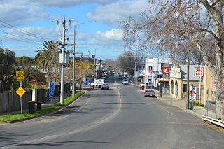
Batesford is a small township located approximately 10 kilometres west of Geelong and 67 kilometres south-west of the state capital, Melbourne.

Ballan is a small town in the state of Victoria, Australia located on the Werribee River, 80 kilometres (50 mi) northwest of Melbourne. At the 2016 census, Ballan had a population of 2,985.

Western Heights College is a secondary school in Hamlyn Heights, Geelong, Australia. Also known as Western Heights Community College, it is situated in Vines Road with its adjoining campus being the Vines Road Community Centre. The college is spread across three buildings, with Year 7 and 8 in the red building, Year 9 and 10 in the grey building and Year 11 and 12 in the yellow building. As of 2016, the school has 605 students, with only 204 being girls and 401 boys. The school currently has a lower than average Index of Community Socio-Educational Advantage (ICSEA) score of 950.

Moorabool is a bounded rural locality of the City of Greater Geelong local government area in Victoria, Australia.
Edward Prowse was an architect working in the Geelong region of Victoria, Australia in the late nineteenth century. He was responsible for many early Geelong buildings, including hotels, mansions and churches.


