
Deer Park is a suburb of Melbourne, Victoria, Australia, 17 km west of Melbourne's Central Business District, located within the City of Brimbank local government area. Deer Park recorded a population of 18,126 at the 2016 Census.

Torquay is a seaside resort in Victoria, Australia, which faces Bass Strait, 21 km south of Geelong and is the gateway to the Great Ocean Road. It is bordered on the west by Spring Creek and its coastal features include Point Danger and Zeally Bay. At the 2016 Census, Torquay had a population of 13,258.

Grovedale is a mainly residential southern suburb of Geelong, Victoria, Australia. At the 2016 census, Grovedale had a population of 14,308.
Lovely Banks is a northern suburb of Geelong, Victoria, Australia. Once an agricultural and rural area, the suburb is quickly developing into a residential area adjoining the Geelong suburbs of Bell Park, Corio and Norlane. At the 2016 Census Lovely Banks had a population of 2,301.
Fyansford is a township on the western edge of Geelong, Victoria, Australia, named after Captain Foster Fyans who came to Geelong as a Police magistrate in October, 1837. It is located at the junction of the Barwon and Moorabool rivers. At the 2016 Census, Fyansford had a population of 196.

Norlane is a northern suburb of Geelong, in Victoria, Australia. Norlane is bordered in the south by Cowies Creek, in the north by Cox Road, in the west by Thompson Road and in the east by Station Street. It is about 7 km from the Geelong central business district and approximately 70 km from the state capital, Melbourne. It is about one kilometre from the shore of Corio Bay. At the 2016 Census, Norlane had a population of 8,306.
Leopold is a residential eastern suburb of Geelong and is a gateway to the Bellarine Peninsula. At the 2016 Census, Leopold had a population of 12,814.
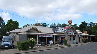
Bell Park is a residential suburb of Geelong, Victoria, Australia. It is located 3 km north-west of the Geelong city centre and is bordered to the north by Cowies Creek, to the east by Thompson Road, to the south by the Midland Highway and to the west by Anakie Road.

North Geelong is a suburb of Geelong in the Australian state of Victoria. The suburb was bypassed by traffic from Melbourne coming from the Princes Freeway by the creation of the Geelong Ring Road, which was complete in 2009. At the 2016 census, North Geelong had a population of 2,966.

Belmont is a southern suburb of Geelong, Victoria, Australia. The name means "beautiful hill". Belmont is geographically separated from the Geelong central business district by the Barwon River. The suburb is primarily residential, with some light industry along Barwon Heads Road. The suburb is part of the City of Greater Geelong local government area. At the 2011 census, Belmont had a population of 13,616.

Hamlyn Heights is a residential suburb of Geelong. It located to the west of the city on hills that overlook Corio Bay.
Bannockburn is a rural township near Geelong, Victoria, Australia, 88 km southwest of Melbourne. It is located in Golden Plains Shire. In the 2016 census, Bannockburn had a population of 5,283.
Bacchus Marsh is an urban centre and suburban locality in Victoria, Australia located approximately 50 kilometres (30 mi) north west of the state capital Melbourne and 14 kilometres (9 mi) west of Melton at a near equidistance to the major cities of Melbourne, Ballarat and Geelong. The population of the Bacchus Marsh urban area was 22,223 at June 2018. Bacchus Marsh is the largest urban area in the local government area of Shire of Moorabool.

Lethbridge is a rural township outside Geelong, Victoria, Australia. Bluestone from Lethbridge quarries was used to build several significant buildings in Melbourne, including the steps to the Parliament House. At the 2016 census, Lethbridge had a population of 1,014.

Inverleigh is a town in Victoria, Australia located 28 kilometres (17 mi) west from the City of Geelong and 87 kilometres (54 mi) from the state capital, Melbourne. The town is divided between Golden Plains Shire and Surf Coast Shire. In the 2016 census, the central area of Inverleigh had a population of 1,474. Inverleigh is known to be a popular stopover destination on the way to Lorne. The Inverleigh Hotel is very popular attracting customers from Geelong.
Batesford is a small township located approximately 10 kilometres west of Geelong and 67 kilometres south-west of the state capital, Melbourne.

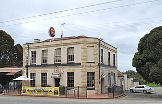
Gordon is a small town in Victoria, Australia, named after settler George Gordon. The town is located on the Old Melbourne Road in the Shire of Moorabool local government area, 95 kilometres (59 mi) west of the state capital, Melbourne. At the 2011 census, Gordon had a population of 1,151.

Moorabool is a bounded rural locality of the City of Greater Geelong local government area in Victoria, Australia.
Curlewis is a bounded rural locality of the City of Greater Geelong local government area on the Bellarine Peninsula, Victoria, Australia. At the 2016 census, Curlewis had a population of 1551.
Cowies Creek Rail Bridge No. 1 is a bridge in Victoria, Australia, on the Geelong-Ballarat rail line in the outer Geelong suburb of Bell Post Hill. Constructed of bluestone in 1860 to cross both Cowies Creek and a roadway, the structure is listed in the Victorian Heritage Register.

